This is not a typical e-book; it is a free, web-based, open-source …
This is not a typical e-book; it is a free, web-based, open-source “textbook” available to anyone interested in using mapping tools to create maps. This e-text focuses primarily on Geographic Information Systems (GIS)—a geospatial technology that enables you to create spatial databases, analyze spatial patterns, and produce maps that communicate more effectively. While this GIS textbook is principally an introduction to GIS, most of the chapter’s concepts are applicable to other geotechnologies including remote sensing, global positioning systems (GPS), Internet mapping, and virtual globes.
Creating good maps and analyzing spatial data is a time consuming and challenging practice, but recently, a new set of powerful mapping tools has enabled almost anyone with a computer to make maps easily and to perform at least some low-level analyses. The results, however, are not encouraging. Most of the new mapmakers do not have adequate training in mapping concepts and spatial analysis principles, and their maps are often improperly designed and do not communicate easily nor effectively. This e-text—GIS Commons—seeks to help you analyze spatial data and communicate more effectively. In short, GIS education is our goal.
Utilize the online GIS of the USGS real-time stream gage network to …
Utilize the online GIS of the USGS real-time stream gage network to introduce basic concepts of data-driven maps and GIS. This exercise can be used independently or with other hydrology exercises.
(Note: this resource was added to OER Commons as part of a batch upload of over 2,200 records. If you notice an issue with the quality of the metadata, please let us know by using the 'report' button and we will flag it for consideration.)
Is your understanding of Cloud GIS a bit hazy? Does thinking about …
Is your understanding of Cloud GIS a bit hazy? Does thinking about it leave you in a fog? We've designed GEOG 865, Cloud and Server GIS, to help you understand how all of the various pieces of architecture fit together. By the end of the class you'll have a clear understanding of esri's and others' offerings in the space, how to implement ArcGIS Enterprise on Amazon EC2, make online maps with Carto and Mapbox, and engage in some blue sky thinking of your own in our weekly discussions about trends and directions.
In GEOG 489, you will learn advanced applications of Python for developing …
In GEOG 489, you will learn advanced applications of Python for developing and customizing GIS software, designing user interfaces, solving complex geoprocessing tasks, and leveraging open source. The course consists of readings, walkthroughs, projects, quizzes, and discussions about advanced GIS programming concepts and techniques, and a final term project. It complements the material covered in GEOG 485: GIS Programming and Customization. Software covered in the course includes: Esri ArcGIS Pro/arcpy, Jupyter Notebook, Esri ArcGIS API for Python, QGIS, GDAL/OGR. Students will also use of the Git version control software for code management, and learn techniques for distributing Python applications to end users.
Bill Gates is credited with saying he would \hire a lazy person …
Bill Gates is credited with saying he would \hire a lazy person to do a difficult job\" with the justification that \"a lazy person will find an easy way to do it.\" GEOG 485 doesn't teach the lazy way to get the job done, but it does teach the scripting way _ which is arguably even better. You've probably heard the \"give a fish\"/\"teach to fish\" saying? That's the gist of GEOG 485: to equip you, in an ArcGIS context, with the ModelBuilder and Python scripting skills to make your boring, repetitive geoprocessing tasks easier, quicker and automatic _ so you can focus on the more interesting (potentially more valuable) work that you (and your employers) really want you to be doing."
Geography 468 provides the geospatial information system professional an overview of systems …
Geography 468 provides the geospatial information system professional an overview of systems analysis and design with emphasis on the concepts behind the process, including: business use case modeling, business object modeling, requirements definition, analysis and preliminary design, and, finally, detailed design. The concepts of the geospatial software and database development process are introduced and the current modeling techniques are addressed within the geospatial systems development paradigm. In a series of related activities, students learn about the methods, tools and the concepts of the systems development process to document a portion of a geospatial system with Unified Modeling Language (UML), the standard graphical notation for modeling application needs.
The goals of this textbook are to help students acquire the technical …
The goals of this textbook are to help students acquire the technical skills of using software and managing a database, and develop research skills of collecting data, analyzing information and presenting results. We emphasize that the need to investigate the potential and practicality of GIS technologies in a typical planning setting and evaluate its possible applications. GIS may not be necessary (or useful) for every planning application, and we anticipate these readings to provide the necessary foundation for discerning its appropriate use. Therefore, this textbook attempts to facilitate spatial thinking focusing more on open-ended planning questions, which require judgment and exploration, while developing the analytical capacity for understanding a variety of local and regional planning challenges. While this textbook provides the background for understanding the concepts in GIS as applicable to urban and regional planning, it is best when accompanied by a hands-on tutorial, which will enable readers to develop an in-depth understanding of the specific planning applications of GIS. Chapters in this text book are either composed by the editors using Creative Common materials, or linked to a book chapter scanned copy in the library reserve. In the end of each chapter, we also provided several discussion questions, together with contextual applications through some web links.
Short Description: This workbook introduces and scaffolds key GIS concepts without relying …
Short Description: This workbook introduces and scaffolds key GIS concepts without relying on canned datasets and projects. Lessons use a problem-solving framework based on the Seven Stages of Action model, connecting software tasks with concepts from the open textbook Essentials of Geographic Information Systems by Jonathan Campbell and Michael Shin (2011). NOTE: Chapter 1 is currently available; Chapters 2 and 3 will be published in 2021 and Chapter 4 is expected to be published in 2022.
Long Description: This workbook introduces and scaffolds key GIS concepts without relying on canned datasets and projects. The intent is to make introductory GIS lessons more relevant to students and emphasize skill transfer. Datasets for use with the workbook lessons may be curated by a course instructor or by the individual learner. Lessons use a problem-solving framework based on the Seven Stages of Action model, derived from usability studies. They connect the software tasks with concepts from the open textbook Essentials of Geographic Information Systems by Jonathan Campbell and Michael Shin (2011). As an Open Educational Resource, this workbook is available for free to all learners, reducing financial barriers that result in educational inequities.
Word Count: 49061
(Note: This resource's metadata has been created automatically by reformatting and/or combining the information that the author initially provided as part of a bulk import process.)
User-friendly Geographic Information Systems (GIS) is the common thread of this collection …
User-friendly Geographic Information Systems (GIS) is the common thread of this collection of presentations, and activities with full lesson plans. The first section of the site contains an overview of cartography, the art of creating maps, and then looks at historical mapping platforms like Hypercities and Donald Rumsey Historical Mapping Project. In the next section Google Earth Desktop Pro is introduced, with lessons and activities on the basics of GE such as pins, paths, and kml files, as well as a more complex activity on "georeferencing" an historic map over Google Earth imagery. The final section deals with ARCGIS Online and StoryMaps with tutorials, basic exercises on pins, paths, and CSV import, and a lesson plan for creating a research project presentation on an historic building in StoryMaps. In addition to an xml file that has been uploaded here to Academic Works, the module is also a live website at https://libguides.brooklyn.cuny.edu/cs-x. The site was created with Libguides software, and is a Community Libguide that can be reused and imported into other LibGuides sites. The website also contains links to two live StoryMaps, one on an Introduction to ARCGIS StoryMaps (https://arcg.is/1SX1zH), and the second, a model assignment on the history of the Fairway building in Red Hook, Brooklyn (https://arcg.is/1nbHP).
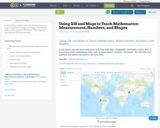
In this activity, students work with measurement and shapes using live web …
In this activity, students work with measurement and shapes using live web maps and images of the Earth at various scales using ArcGIS Online. Time required: 2 class periods (100 minutes total).
This book is designed to be used as a class text but …
This book is designed to be used as a class text but should be easily accessible to programmers interested in Web Programming. It should even be accessible to an advanced hobbyist.
The original goal behind this text was to help students doing research with me in Web based mapping applications, generally using Open Layers. The idea was to provide persistent storage using REST and simple http request from JavaScript to store the data on a server.
To address the cost of resources for exercise manuals in GIS, I …
To address the cost of resources for exercise manuals in GIS, I have developed a series of class exercises that can be used with QGIS, a free and open source software. In addition, some class activities address more general ideas associated with cartography, such as color theory. To make these resources fully accessible to students, I have recorded publicly available videos documenting how these class activities can be completed. There is one video for each classroom lesson in this course offering, and links to all of the videos on the website Vimeo are linked to.
DESCRIPTION Develops skills needed to produce maps using ArcGIS Desktop software. Outlines cartographic principles and map use. Emphasis on mapping techniques within a GIS. Intended for students enrolled in GIS or UAS programs.
LEARNING OUTCOMES 1. Demonstrate knowledge and apply skills essential to the discipline. 2. Coordinate and manage the delivery of reliable, valid, GIS data including analysis and specialized user needs products. 3. Communicate effectively and appropriately within a professional setting in both written and oral form. 4. Utilize professional communication skills to achieve project outcomes in collaboration with GIS users across disciplines. 5. Research, interpret and apply data/information in the professional setting. 6. Develop and implement GIS services for users who may or may not be GIS knowledgeable.
The purpose of this text is to promote understanding of the Geographic …
The purpose of this text is to promote understanding of the Geographic Information Science and Technology enterprise (GIS&T, also known as “geospatial”).
One lecture for GEOG 265 – Introduction to GIS with video resources …
One lecture for GEOG 265 – Introduction to GIS with video resources and edited auto-generated captions. Revised text has been published in these videos as new subtitles in English and Spanish.
Essentials of Geographic Information Systems integrates key concepts behind the technology with …
Essentials of Geographic Information Systems integrates key concepts behind the technology with practical concerns and real-world applications. Recognizing that many potential GIS users are nonspecialists or may only need a few maps, this book is designed to be accessible, pragmatic, and concise. Essentials of Geographic Information Systems also illustrates how GIS is used to ask questions, inform choices, and guide policy. From the melting of the polar ice caps to privacy issues associated with mapping, this book provides a gentle, yet substantive, introduction to the use and application of digital maps, mapping, and GIS.
The purpose of this text is to promote understanding of the Geographic …
The purpose of this text is to promote understanding of the Geographic Information Science and Technology enterprise (GIS&T, also known as “geospatial”).
Essentials of Geographic Information Systems integrates key concepts behind the technology with …
Essentials of Geographic Information Systems integrates key concepts behind the technology with practical concerns and real-world applications. Recognizing that many potential GIS users are nonspecialists or may only need a few maps, this book is designed to be accessible, pragmatic, and concise. Essentials of Geographic Information Systems also illustrates how GIS is used to ask questions, inform choices, and guide policy. From the melting of the polar ice caps to privacy issues associated with mapping, this book provides a gentle, yet substantive, introduction to the use and application of digital maps, mapping, and GIS.
The course discusses several Geopgraphical Information System (GIS) and Remote Sensing (RS) …
The course discusses several Geopgraphical Information System (GIS) and Remote Sensing (RS) tools relevant for analysis of (problems in and aspects of) water systems. Within the course, several applications are introduced. These applications include GIS tools to determine mapping of surface water systems (catchment delineation, reservoirs and canal systems). The RS tools include determination of evaporation and soil moisture patterns, and measurement of water levels in surface water systems. In exercises and lectures, different tools and applications are offered. For each application, assignments are given to allow students to acquire relevant skills. The course structure combines assignments and introductory lectures. Each week participants work on one assignment. These assignments are discussed in the next lecture and graded. Each week a new assignment is introduced, together with supporting materials (an article discussing the relevant application) and lectures (introducing theoretical issues). The study material of the course consists of a study guide, assignments, lecture material and articles. The final mark is the average of the grades of the individual assignments.
Geospatial System Analysis and Design surveys the process of GIS design through …
Geospatial System Analysis and Design surveys the process of GIS design through critical reading/writing and collaborative discussion. Key topics in the course outline the broad range of current GIS systems, how they are designed and evaluated, and how emerging technologies may impact their design and implementation in the near future. In particular, students will develop a term-long project where they propose a realistic problem scenario that requires the skills and understanding required to effectively complete a geospatial system specification, design, and implementation. Students completing this course are able to develop a comprehensive system design plan that takes into account current technologies as well as emerging technology trends.
An Open Geospatial Textbook Short Description: The purpose of this text is …
An Open Geospatial Textbook
Short Description: The purpose of this text is to promote understanding of the Geographic Information Science and Technology enterprise (GIS&T, also known as "geospatial").
Long Description: The purpose of this text is to promote understanding of the Geographic Information Science and Technology enterprise (GIS&T, also known as “geospatial”).
Word Count: 102175
(Note: This resource's metadata has been created automatically by reformatting and/or combining the information that the author initially provided as part of a bulk import process.)
No restrictions on your remixing, redistributing, or making derivative works. Give credit to the author, as required.
Your remixing, redistributing, or making derivatives works comes with some restrictions, including how it is shared.
Your redistributing comes with some restrictions. Do not remix or make derivative works.
Most restrictive license type. Prohibits most uses, sharing, and any changes.
Copyrighted materials, available under Fair Use and the TEACH Act for US-based educators, or other custom arrangements. Go to the resource provider to see their individual restrictions.