This page features a brief introduction to the several theories about the …
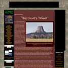
This page features a brief introduction to the several theories about the geological processes that formed Devil's Tower, which rises 1,267 feet above the nearby Belle Fourche River and is still considered a sacred place by some Native American Tribes. Information on climbing the tower as well as images and a cross section are provided.
In this culminating activity, students will be assessed on what they have …
In this culminating activity, students will be assessed on what they have learned during the Geology unit of their Earth Science class. After conducting classroom and field studies on geology students will utilize this knowledge to interpret the rock layers and formation of the Grand Canyon. Outside of class students will read/review a website and complete a study guide to be reviewed by the teacher to assess students' learning. Following teacher review of study guides, the next class period(s) will be a discussion and questioning session(s) on the formation of the Grand Canyon.
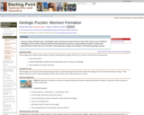
Images of faulted strata, tilted turbidites, and beach rocks bring the field …
Images of faulted strata, tilted turbidites, and beach rocks bring the field into the classroom, giving students practice in doing what geoscientists do. These images are examples of geologic puzzles.
(Note: this resource was added to OER Commons as part of a batch upload of over 2,200 records. If you notice an issue with the quality of the metadata, please let us know by using the 'report' button and we will flag it for consideration.)
This activity provides examples of (1) a student experience survey and (2) …
This activity provides examples of (1) a student experience survey and (2) an assessment quiz that can be used on the first day of class. The survey reveals students' backgrounds in terms of related coursework, computer skills, and geologic experiences that the instructor can draw upon throughout the semester. The quiz gives helps to determine students' familiarity with selected concepts and terminology of sedimentary geology and their ability to apply simple mathematical skills (algebra and trig) to relevant problems. Both tools can be used to identify students who may need extra attention early in the course and to plan for supplementary instructional sessions on topics for which many students are deficient.
(Note: this resource was added to OER Commons as part of a batch upload of over 2,200 records. If you notice an issue with the quality of the metadata, please let us know by using the 'report' button and we will flag it for consideration.)
The introductory level course teaches geology majors basic skills in the context …
The introductory level course teaches geology majors basic skills in the context of a field-based problem, the integrating theme for the semester, so that they can more rapidly achieve an advanced skill level in their upper-division courses.
(Note: this resource was added to OER Commons as part of a batch upload of over 2,200 records. If you notice an issue with the quality of the metadata, please let us know by using the 'report' button and we will flag it for consideration.)
Based on a schematic diagram of an outcrop provided in the first …
Based on a schematic diagram of an outcrop provided in the first question, students are asked to list the relative ages of the four different rock units and provide the reasoning behind their interpretation based on the principles of relative age and the processes involved in the formation of each rock. Students are told that there are two possible solutions and must describe both. The second part of question one asks students to describe the geologic evidence they would look for in the outcrop to determine which of the solutions was likely correct.
The second question of the assignment is about numerical age dating. Students are asked to list what could be dated in each rock (e.g. minerals, fossils) and which particular process during the formation of each rock would be dated in doing so.
(Note: this resource was added to OER Commons as part of a batch upload of over 2,200 records. If you notice an issue with the quality of the metadata, please let us know by using the 'report' button and we will flag it for consideration.)
In this culminating activity, students will be assessed on what they have …
In this culminating activity, students will be assessed on what they have learned during the Geology unit of their Earth Science class. After conducting classroom and field studies on geology students will utilize this knowledge to interpret the rock layers and formation of the Grand Canyon. Outside of class students will read/review a website and complete a study guide to be reviewed by the teacher to assess students' learning. Following teacher review of study guides, the next class period(s) will be a discussion and questioning session(s) on the formation of the Grand Canyon.
Course outline and reading list; spreadsheet with list of readings by topic …
Course outline and reading list; spreadsheet with list of readings by topic with licensing info for each.
Course Description: Covers environmental topics that are primarily geological in nature. Includes geology basics, soil resources, hydrogeology, nonrenewable mineral and energy resources, perpetual energy resources, and solid waste. The associated laboratories will illustrate these topics and may include fieldwork.
Upon completion of the course students should be able to:
Express graphically, orally or in writing, basic elements of environmental earth-sciences. Identify and express geological interactions of humans and the environment. Utilize field and laboratory methods/technologies to measure and describe environmental factors. Demonstrate an understanding of geologic time scales and processes.
Each student in the Geological Oceanography class writes a series of one-page …
Each student in the Geological Oceanography class writes a series of one-page papers for topics throughout the semester, presents one topic as a 3 to 5 minute oral presentation, and revises all papers as a portfolio for submission at the end of the semester. The eight topics are objects in the solar system, minerals, rocks, hydrothermal vents, volcanoes & earthquakes, marine sediments, hurricanes & typhoons, and tides.
This website contains a geologic map of the Island Park, Idaho area. …
This website contains a geologic map of the Island Park, Idaho area. The map shows rocks, deposits, faults, calderas, flows, and other geologic features of interest.
Students study how geology relates to the frequency of large-magnitude earthquakes in …
Students study how geology relates to the frequency of large-magnitude earthquakes in Japan. Using the online resources provided through the Earthquakes Living Lab, students investigate reasons why large earthquakes occur in this region, drawing conclusions from tectonic plate structures and the locations of fault lines. Working in pairs, students explore the 1995 Kobe earthquake, why it happened and the destruction it caused. Students also think like engineers to predict where other earthquakes are likely to occur and what precautions might be taken. A worksheet serves as a student guide for the activity.
The goal of this activity is to provide students an opportunity to …
The goal of this activity is to provide students an opportunity to connect soil science to surficial geology by using a Soil Surveys. By the end of the activity, students should be able to use a Soil Survey to identify and interpret landforms and surficial features. This activity can be adapted to variety of process (ex. eolian deposits, glacial deposits, bedrock weathering, etc.). County-level soil surveys are available in both paper and online formats for the majority of the United States. Designed for a geomorphology course Has minimal/no quantitative component
(Note: this resource was added to OER Commons as part of a batch upload of over 2,200 records. If you notice an issue with the quality of the metadata, please let us know by using the 'report' button and we will flag it for consideration.)
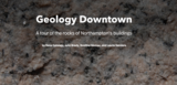
Downtown Northampton is a geological museum, displaying a variety of rocks that …
Downtown Northampton is a geological museum, displaying a variety of rocks that have been quarried, sculpted, and incorporated into the buildings. Many visitors to the city walk by these rocks without noticing them at all, or seeing them only as architectural features, not museum offerings. This guide has been created to help you see the geological wonders that support, decorate, and enhance Northampton's buildings.
Upon arrival in the lab, students are designated as an engineer, a …
Upon arrival in the lab, students are designated as an engineer, a biologist, or a geologist. Working in these groups, each group uses available Mars data (including, but not limited to, Mars geologic maps, topography, thermal inertia data) to identify their top three landing sites on the basis of provided criteria. In jig-saw fashion, new groups are generated consisting of one geologist, one engineer, and one geologist. These new groups must agree on their top three landing sites. Finally, the entire class must agree on a landing site.
(Note: this resource was added to OER Commons as part of a batch upload of over 2,200 records. If you notice an issue with the quality of the metadata, please let us know by using the 'report' button and we will flag it for consideration.)
Radiometric age determination using parent/daughter composition and a radiometric decay curve. (Note: …
Radiometric age determination using parent/daughter composition and a radiometric decay curve.
(Note: this resource was added to OER Commons as part of a batch upload of over 2,200 records. If you notice an issue with the quality of the metadata, please let us know by using the 'report' button and we will flag it for consideration.)
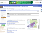
Students examine and describe samples of rhyolite, pumice, and tuff, having seen …
Students examine and describe samples of rhyolite, pumice, and tuff, having seen samples of mafic volcanic rocks in a previous lab exercise. They then answer a series of questions about the distribution of volcanic rocks on the geologic map of Yellowstone National Park. Finally, they synthesize what they've learned by answering the question, "In two or three sentences, what does this map show you about the volcanic activity of the Yellowstone hotspot?"
(Note: this resource was added to OER Commons as part of a batch upload of over 2,200 records. If you notice an issue with the quality of the metadata, please let us know by using the 'report' button and we will flag it for consideration.)
The purpose of the activity is to get students out of the …
The purpose of the activity is to get students out of the traditional classroom setting and to spend several hours navigating their way between various localities on campus where different rock types are used for a variety of purposes. Students are encouraged to bring along their introductory geology laboratory manuals to remind them of the techniques used to correctly identify rock types. The activity is designed to promote enjoyment of the task (clues need to be "solved" to figure out the location of the next outcrop in the sequence) and to encourage students to follow the task through to completion. As a result, students invariably spend many hours engaged in the activity despite the fact that it is completely optional.
(Note: this resource was added to OER Commons as part of a batch upload of over 2,200 records. If you notice an issue with the quality of the metadata, please let us know by using the 'report' button and we will flag it for consideration.)
Students examine the effects of geology on earthquake magnitudes and how engineers …
Students examine the effects of geology on earthquake magnitudes and how engineers anticipate and prepare for these effects. Using information provided through the Earthquakes Living Lab interface, students investigate how geology, specifically soil type, can amplify the magnitude of earthquakes and their consequences. Students look in-depth at the historical 1906 San Francisco earthquake and its destruction thorough photographs and data. They compare the 1906 California earthquake to another historical earthquake in Kobe, Japan, looking at the geological differences and impacts in the two regions, and learning how engineers, geologists and seismologists work to predict earthquakes and minimize calamity. A worksheet serves as a student guide for the activity.
No restrictions on your remixing, redistributing, or making derivative works. Give credit to the author, as required.
Your remixing, redistributing, or making derivatives works comes with some restrictions, including how it is shared.
Your redistributing comes with some restrictions. Do not remix or make derivative works.
Most restrictive license type. Prohibits most uses, sharing, and any changes.
Copyrighted materials, available under Fair Use and the TEACH Act for US-based educators, or other custom arrangements. Go to the resource provider to see their individual restrictions.