This is a introductory lab exercise that is intended to convey the …
This is a introductory lab exercise that is intended to convey the concept of the logarithmic scale used for earthquake magnitude. The students will visualize magnitude as a distance over the ground, by using a contrived conversion between magnitude and distance. Using distances helps the students understand how logarithmic scales, like magnitude, work because this is one of the few scales that students are familiar with that spans several orders of magnitude. Students typically use calculators to determine the distance associated with each magnitude. Maps should be provided in the lab/classroom that are on several scales: campus maps, city maps, state maps, and a national map work well. This activity gives the students practice in making unit conversions and in developing arguments by analogy. Addresses student fear of quantitative aspect and/or inadequate quantitative skills Addresses student misconceptions
(Note: this resource was added to OER Commons as part of a batch upload of over 2,200 records. If you notice an issue with the quality of the metadata, please let us know by using the 'report' button and we will flag it for consideration.)
This game has students simulate the propagation of P and S waves …
This game has students simulate the propagation of P and S waves after an earthquake and to use the lag between these to determine where in the simulation the earthquake occurred.
(Note: this resource was added to OER Commons as part of a batch upload of over 2,200 records. If you notice an issue with the quality of the metadata, please let us know by using the 'report' button and we will flag it for consideration.)
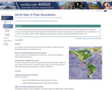
The plate tectonics mapping activity allows students to easily begin to identify …
The plate tectonics mapping activity allows students to easily begin to identify basic tectonic processes on a global scale. As students become aware of plate movements, they begin to identify patterns that set the stage for deeper understanding of a very complex topic. The activity uses a simple "Where's Waldo" approach to identify tectonic symbols on a laminated World Plate Tectonic map.
(Note: this resource was added to OER Commons as part of a batch upload of over 2,200 records. If you notice an issue with the quality of the metadata, please let us know by using the 'report' button and we will flag it for consideration.)
No restrictions on your remixing, redistributing, or making derivative works. Give credit to the author, as required.
Your remixing, redistributing, or making derivatives works comes with some restrictions, including how it is shared.
Your redistributing comes with some restrictions. Do not remix or make derivative works.
Most restrictive license type. Prohibits most uses, sharing, and any changes.
Copyrighted materials, available under Fair Use and the TEACH Act for US-based educators, or other custom arrangements. Go to the resource provider to see their individual restrictions.