Build your own system of heavenly bodies and watch the gravitational ballet. …
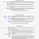
Build your own system of heavenly bodies and watch the gravitational ballet. With this orbit simulator, you can set initial positions, velocities, and masses of 2, 3, or 4 bodies, and then see them orbit each other.
Build your own system of heavenly bodies and watch the gravitational ballet. …
Build your own system of heavenly bodies and watch the gravitational ballet. With this orbit simulator, you can set initial positions, velocities, and masses of 2, 3, or 4 bodies, and then see them orbit each other.
In this activity, students play the roles of detectives investigating the loss …
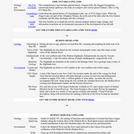
In this activity, students play the roles of detectives investigating the loss of a city's water supply by evaporation. They will design an experiment to see whether heat or wind causes the greater loss of water, conduct the experiment, and write a report detailing their findings.
The courses on this portal are or will be Zero-Textbook-Cost courses. Course …
The courses on this portal are or will be Zero-Textbook-Cost courses. Course faculty are creating and adopting teaching, learning and research materials that permit no-cost access, use, adaptation and redistribution by others with no or limited restrictions.
The following course pages provide links to the syllabus and open course content, websites and learning tools:
Biology SCB 201 – General Biology I Chemistry SCC 110 – Foundations of Chemistry SCC 201 – General Chemistry I SCC 202 – General Chemistry II Physics and Astronomy SCP 101 – Topics in Physics SCP 105 – Life in the Universe SCP 140 – Topics in Astronomy SCP 201 – Fundamentals of Physics I SCP 202 – Fundamentals of Physics II
This lesson unit provides an insight into the navigational methods of the …
This lesson unit provides an insight into the navigational methods of the Bronze Age Mediterranean peoples. The students explore the link between history and astronomical knowledge. Besides an overview of ancient seafaring in the Mediterranean, the students use activities to explore early navigational skills using the stars and constellations and their apparent nightly movement across the sky. In the course of the activities, they become familiar with the stellar constellations and how they are distributed across the northern and southern sky.
The Adirondack Mountains tour is part of the New York Landscape Regions …
The Adirondack Mountains tour is part of the New York Landscape Regions Collection of Google Earth Tours, created by a group of New York State science educators. This tour provides an introduction to the geology of the Great Range and the High Peaks as viewed from Algonquin Peak. It also addresses the issue of acid rain, which is a persistent environmental concern in the Adirondacks.
The Allegheny Plateau tours are part of the New York Landscape Regions …
The Allegheny Plateau tours are part of the New York Landscape Regions Collection of Google Earth Tours, created by a group of New York State science educators. These tours showcase examples of Allegheny geology, including the geomorphology of glacial features near Tully, New York, southern Cayuga Lake, the geology and geomorphology of Letchworth State Park and its waterfalls, as well as waterfalls and creeks in the Ithaca Gorges. Schoharie Creek can be toured from its mouth to its source, the St. Lawrence Chesapeake and Valley Heads Moraine can be investigated to examine drainage patterns, and another tour investigates the unique geology and ecology of the Rome Sand Plains. Environmental tours also address the 2006 flooding in the Allegheny Plateau near Port Jarvis and Livingston Manor and provide an overview of the water supply system of the City of New York.
The Atlantic Coastal Plain tour is part of the New York Landscape …
The Atlantic Coastal Plain tour is part of the New York Landscape Regions Collection of Google Earth Tours, created by a group of New York State science educators. This tour introduces students to glacial erratics on Long Island, the Ronkonkoma terminal moraine, and the Rock Hill erratic. Coastal erosion and deposition can be studied by viewing dunes, beaches, and wave cut banks.
The Champlain Lowlands tour is part of the New York Landscape Regions …
The Champlain Lowlands tour is part of the New York Landscape Regions Collection of Google Earth tours, created by a group of New York State science educators. This tour includes views of the gorge of the Ausable River, cut through Late Cambrian Potsdam Sandstone, and the geology of the Champlain Thrust Fault, a low angle thrust fault formed as the proto-Atlantic Ocean closed during the Taconic Oregeny. When it was still connected to the ocean, Lake Champlain was home to whales, whose fossils are now entombed in the lake sediments. The tour also includes classroom activities for students.
The Erie Ontario Lowlands tour is part of the New York Landscape …
The Erie Ontario Lowlands tour is part of the New York Landscape Regions Collection of Google Earth tours. This tour includes glacial history, features, and views of Niagara Falls, the Niagara Escarpment, current and former spillways, and the locks at Lockport, New York. Students can also learn about the geology and glacial history of Canandaigua Lake, one of New York's Finger Lakes, which discharges into the Lowlands. There is also a lab activity in which students analyze maps, images, and information to perform an environmental assessment of the Cascade Mill development.
The Hudson Highlands tour is part of the New York Landscape Regions …
The Hudson Highlands tour is part of the New York Landscape Regions Collection of Google Earth Tours, created by a group of New York State science educators. This tour introduces Hudson Highlands geology, including glaciology at Bear Mountain, views of the Highlands, and the Ramapo Fault to the south. It also offers other information about the area, including some animals, New York City's water supply, and the Great Swamp.
The Hudson Mohawk Lowlands tour is part of the New York Landscape …
The Hudson Mohawk Lowlands tour is part of the New York Landscape Regions Collection of Google Earth tours, created by a group of New York State science educators. This tour introduces students to limestone quarrying along the western shore of the Hudson River south of Catskill, New York. They can follow the courses of the Mohawk River and Erie Canal eastward to the Cohoes Falls and the confluence of the Mohawk with the Hudson River. It also provides a look at issues involved with the cleanup of PCB-laden sediments in the Hudson River.
The Newark Lowlands tour is part of the New York Landscape Regions …
The Newark Lowlands tour is part of the New York Landscape Regions Collection of Google Earth Tours created by a group of New York State science educators. This tour lets students see the Ramapo Fault at the Lowlands' northwestern boundary and the Palisades Sill on the western shore of the Hudson River. The Sparkill Gap, a pre-Ice Age weak spot in the Palisades Sill through which the Hudson River once flowed, can be observed. There is also an activity in which students explore the economic, social, and environmental issues associated with constructing the Tappan Zee Bridge over the Hudson River.
The St. Lawrence Lowlands tour is part of the New York Landscape …
The St. Lawrence Lowlands tour is part of the New York Landscape Regions Collection of Google Earth Tours. This tour allows students to explore the Thousand Islands, formed of granite which has withstood the erosive energy of the St. Lawrence River, creating thousands of islands ranging in size from single rocks to over 25 square miles. There is also an activity in which students map some of the many shipwrecks that have accumulated at the entrance to the St. Lawrence Seaway.
The Taconic Mountains tour highlights the geology and natural environment of several …
The Taconic Mountains tour highlights the geology and natural environment of several landscape regions, including the structure of the Highlands Province basement rocks, which were affected by the Taconic Orogeny. Students can view biotite-rich schists and the tight isoclinic folds of the Walloomsac Formation, as well as the Taconic angular unconformity at the south end of Becraft Mountain. Bedding thrusts are also evident within the Roundout Formation and overlying Manlius Formation. They can also examine metamorphosed Briarcliff Dolostone containing yellow, white and black chert layers and Everett Phylite, which represents a metamorphic lithologic transition from slate to phyllite. Dramatically folded calcareous rocks are visible at the Bennington, Vermont bypass, and students can also view Stark's Knob, where pillow lavas formed as Ordovician basalts erupted under the waters of a shallow sea.
The Manhattan Prong tour is part of the New York Landscape Regions …
The Manhattan Prong tour is part of the New York Landscape Regions Collection of Google Earth Tours. This tour takes students to Central Park in New York City to see metamorphic rock, glacial features, differential weathering, and Cleopatra's Needle, an Egyptian obelisk brought to the city in 1881. They can also examine bedrock, float, mass wasting, jointing, and glacial polish in the Pound Ridge Reservation, and observe a metamorphic outcrop of Fordham Gneiss near Katonah, New York. The convergent boundary features of the Staten Island serpentine belt, formed during the Taconic Orogeny, can be viewed, and students can follow the Mianus River Gorge as it crosses the Cameron's Line fault. There is also a tour of the New York City water supply system with a lab activity to accompany it.
The Tug Hill Plateau tour is part of the New York Landscape …
The Tug Hill Plateau tour is part of the New York Landscape Regions Collection of Google Earth Tours, created by a group of New York State science educators. The tour introduces students to the many waterfalls of the plateau, which is formed of layers of sandstone and shale. It also points out that the plateau recieves more snow than any location east of the Rocky Mounatins due to the lake-effect from Lake Ontario and its elevation, which is 2,100 feet at the highest point. There is also a visit to a fish hatchery.
No restrictions on your remixing, redistributing, or making derivative works. Give credit to the author, as required.
Your remixing, redistributing, or making derivatives works comes with some restrictions, including how it is shared.
Your redistributing comes with some restrictions. Do not remix or make derivative works.
Most restrictive license type. Prohibits most uses, sharing, and any changes.
Copyrighted materials, available under Fair Use and the TEACH Act for US-based educators, or other custom arrangements. Go to the resource provider to see their individual restrictions.