This activity is a field investigation where students reconstruct parts of Winona's …
This activity is a field investigation where students reconstruct parts of Winona's Paleozoic environment through observations of a local outcrop and the application of basic geologic principles.
In this problem-based learning module, students will ‘dig’ for fossils in a digital …
In this problem-based learning module, students will ‘dig’ for fossils in a digital environment, using the advanced graphing techniques of line-of-best-fit and piecewise functions to look for different kinds of trends in the health of the history of the earth. They will apply this information to their knowledge of the laws of superposition and index fossils to form a complete analysis in the historical health as well as to predict where we are going in the future.
In this lesson students will learn how Native American tribes living in …
In this lesson students will learn how Native American tribes living in what is now Oregon incorporated geologic knowledge into their lifeways and cultures. It will describe tribes’ use of stone tools, designation of prominent landforms as significant and meaningful places, and oral traditions they maintained regarding geologic events to help them understand and organize the world they lived in. This lesson assumes students have some familiarity with or prior instruction in earth science concepts such as Oregon landforms, the rock cycle, plate tectonics, and earthquakes and tsunamis.
The primary objective of this U.S. Geological Survey Open-file Report is to …
The primary objective of this U.S. Geological Survey Open-file Report is to improve seismic-hazard assessments in regions of Wyoming with low to moderate levels of historic seismicity. A map and pamphlet are available for download in PDF format. The map shows faults and folds with evidence of Quaternary movement including data on timing of the most recent movement, sense of movement, slip rate, and continuity of surface expression.
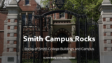
The Smith College campus may seem to be an unlikely destination for …
The Smith College campus may seem to be an unlikely destination for a geological field trip. Buildings, pavement, grassy lawns, and garden plantings cover the sediment, glacial till, and sandstone bedrock that are evidence of the local geologic history. Nevertheless, there are many interesting rocks easily visible on the campus, most of them as construction materials for buildings. Sliced, sculpted, and in some cases polished, the rocks found as building stones are easy to see and provide interesting examples of a variety of rock types worthy of our attention. This guide provides information about many of the building stones on the Smith College campus.
This is a unit plan where students will understand how Earth is …
This is a unit plan where students will understand how Earth is systems of interacting components (spheres) and how changing one sphere will affect another. The carbon cycle is studied in quantity of carbon in each reservoir and how human and natural processes move carbon from one reservoir to another in two different time scales. The carbon cycle is studied qualitatively through demonstrations or labs with students developing models of the from of carbon in each reservoir.
Reading and constructing geologic maps is one skill that every geologists has …
Reading and constructing geologic maps is one skill that every geologists has to master. Initially, this means that we have to understand the symbols that are used on geologic maps. Once we know the general meaning of these symbols, we will have to learn how to measure and plot them. The measuring is generally done using a magnetic compass. Finally, we have to plot the data on a map so that others understand the geology based on our mapping.
(Note: this resource was added to OER Commons as part of a batch upload of over 2,200 records. If you notice an issue with the quality of the metadata, please let us know by using the 'report' button and we will flag it for consideration.)
In this activity, students are assigned a geologic profile based on a …
In this activity, students are assigned a geologic profile based on a set of rock samples and are asked to arrange the samples from oldest to youngest. They then identify each rock type and record their observations of what processes might have formed it, what type of sediment it is made of, what sort of environment it might have formed in, and what agents of erosion or deposition might have been at work. Using this information, they will write a story explaining the geologic history represented by their profile and describe in detail how it might have formed.
This is a set of three activities about how scientists study other …
This is a set of three activities about how scientists study other worlds. Learners will explore and compare the features of Mars and Earth, discuss what the features suggest about the history of Mars, and create a model to help them understand how scientists view other worlds. The activities help to show why scientists are interested in exploring Mars for evidence of past life, and address the question: "Why are we searching for life on Mars?" It also includes specific tips within each activity for effectively engaging girls in STEM. This is activity 4 in Explore: Life on Mars? that was developed specifically for use in libraries.
"Lifelines and Earth lines" is the first lab activity of the semester …
"Lifelines and Earth lines" is the first lab activity of the semester in an undergraduate, introductory-level geoscience course for non-majors and majors. It requires no homework or preparation by students. The first goal is for students to get to know one another and the instructor. Students work in teams of 2, construct lines representing the length of their lives on large easel paper, mark important life events on their lines, and introduce their partners to the class (about 25 minutes total). Students then construct lines representing the length of earth history and mark important geologic events, and answer questions about geologic time and events (about 25 minutes). This part of the lab has the goal of helping students gain a better understanding of geological time scales and the current scientific models that attempt to explain the evolution and future of our planet. The questions ask them to think about why we "count" time differently for people (moving forward from birth) and geology (going back from the present). The events chosen relate to appearances of major life forms and mass extinctions; questions ask them to think about these events and what evidence for them might be preserved in the geologic record. These questions serve as a springboard for discussion of geologic time and evolution as controversial topics.
(Note: this resource was added to OER Commons as part of a batch upload of over 2,200 records. If you notice an issue with the quality of the metadata, please let us know by using the 'report' button and we will flag it for consideration.)
Learn about the challenging research work of three outstanding fellowship students at …
Learn about the challenging research work of three outstanding fellowship students at Scripps on topics as diverse as climate science, coastal Geology|Earth Science, and deep-sea diversity as they share their research discoveries and their visions for the future of their disciplines. (59 minutes)
In this activity, students simulate deformational effects on Earth's crust using peanut …
In this activity, students simulate deformational effects on Earth's crust using peanut butter and jelly sandwiches. These common sandwich components are used to model geologic features such as synclines, anticlines, and monoclines, and to demonstrate the effects of stresses and strains.
Trench logs of the San Andreas Fault at Pallett Creek, CA are …
Trench logs of the San Andreas Fault at Pallett Creek, CA are the data base for a lab or homework assignment that teaches about relative dating, radiometric dating, fault recurrence intervals and the reasons for uncertainty in predicting geologic phenomena. Students are given a trench log that includes several fault strands and dated stratigraphic horizons. They estimate the times of faulting based on bracketing ages of faulted and unfaulted strata. They compile a table with the faulting events from the trench log and additional events recognized in nearby trenches, then calculate maximum, minimum and average earthquake recurrence intervals for the San Andreas Fault in this area. They conclude by making their own prediction for the timing of the next earthquake. While basically an exercise in determining relative ages of geologic horizons and events, this assignment includes radiometric dates, recurrence intervals, and an obvious societal significance that has been well received by students. With minor modifications, this exercise has been used successfully with elementary school students through university undergraduate geology majors. Less experienced students can work in groups, with each group determining the age of a single fault strand; combining the results from different groups and calculating recurrence intervals can then be done as a class activity. University students in an introductory geology course for non-majors can add their data from the trench log to an existing table with other faulting events already provided. The exercise can be made more challenging for advanced students by using logs from several different trenches, requiring students to design the table themselves, and giving students the uncertainties for the radiometric dates rather than simple ages for the strata. Most students -- at all levels -- are initially frustrated by their inability to determine an exact date of faulting from the available data. They gain a new appreciation for the task of the geoscientist who attempts to relate geologic phenomena to the human, rather than geologic, time scale.
(Note: this resource was added to OER Commons as part of a batch upload of over 2,200 records. If you notice an issue with the quality of the metadata, please let us know by using the 'report' button and we will flag it for consideration.)
This is an in-depth assignment to explore and write about the history …
This is an in-depth assignment to explore and write about the history of life as represented at the Museum of the Earth at the Paleontological Research Institution in Ithaca, New York. Students will examine several facets of paleontology: paleoecology, paleoclimate, geologic time, and mass extinctions.
Spreadsheets Across the Curriculum module/Geology of National Parks course. Students study how …
Spreadsheets Across the Curriculum module/Geology of National Parks course. Students study how discharge per unit area varies with elevation in the high country of Glacier National Park from USGS hydrograph data from Swiftcurrent Creek and its tributary Grinnell Creek..
Is climate variability affected by the ongoing addition of greenhouse gasses to …
Is climate variability affected by the ongoing addition of greenhouse gasses to Earth's atmosphere? Join Dr. Chris Charles as he explains how geological archives are shedding new light on the human impact on climate. (52 minutes)
BRIGHT Girls was a project to build broader participation in the sciences, …
BRIGHT Girls was a project to build broader participation in the sciences, led by the University of Alaska Fairbanks and funded by the National Science Foundation. We sought to increase students' motivation and capacity to pursue careers in STEM by engaging them in studies of nearby natural environments. The developed lesson plans may be used in formal or informal educational settings, e.g., in a summer academy or across multiple class periods. These investigations help students explore the relationships among life history and ecosystems, connecting biology to geology and remote sensing.
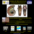
A diverse collection of lower Cretaceous (Albian) fossils is featured on this …
A diverse collection of lower Cretaceous (Albian) fossils is featured on this site. Fossil photos, illustrations and information about each suborder are provided for an array of fossil groups. Specific fossil groups include Ammonoidea, Bivalvia, Cephalopoda, Cnidaria (Corals), Echinodermata, Fish, Foraminifera, Gastropoda, Ostracoda, and Scaphopoda. Short discussions of United Kingdom geology, Albian stratigraphy, geologic time and fossil imaging techniques are also included.
No restrictions on your remixing, redistributing, or making derivative works. Give credit to the author, as required.
Your remixing, redistributing, or making derivatives works comes with some restrictions, including how it is shared.
Your redistributing comes with some restrictions. Do not remix or make derivative works.
Most restrictive license type. Prohibits most uses, sharing, and any changes.
Copyrighted materials, available under Fair Use and the TEACH Act for US-based educators, or other custom arrangements. Go to the resource provider to see their individual restrictions.