The objective of this project is to use a sample of sand …
The objective of this project is to use a sample of sand from a give are to tell its geologic history. Each student is given a 50 mL tube of sand labeled with the latitude and longitude of where it was found. They must then use this information along with analysis of the sand itself to tell the story of its formation.
Students are given colored sand and a plexiglas box with a sliding …
Students are given colored sand and a plexiglas box with a sliding base. They make relatively thin, flat layers of sand (each layer has its own color)completely covering the base of the boxes then they move the base in one direction forcing the sand to pile up against the backstop side of the box. Then they measure the topography, make a topo map and construct cross sections. Has minimal/no quantitative component
This activity challenges students to write three rock descriptions and edit the …
This activity challenges students to write three rock descriptions and edit the work of their peers. The goal is for students to realize the importance of rock descriptions, learn how to write them, and gain practice.
The process of mud settling in a graduated cylinder was filmed as …
The process of mud settling in a graduated cylinder was filmed as a time lapse series over about 2 hours. Students observe and analyze the sedimentation process.
(Note: this resource was added to OER Commons as part of a batch upload of over 2,200 records. If you notice an issue with the quality of the metadata, please let us know by using the 'report' button and we will flag it for consideration.)
This problem set introduces univariate and bivariate sensitivity analysis using the horizontal …
This problem set introduces univariate and bivariate sensitivity analysis using the horizontal velocity profile of the wind in Matlab. This can be easily adapted for river flow, wind chill temperature, etc.
(Note: this resource was added to OER Commons as part of a batch upload of over 2,200 records. If you notice an issue with the quality of the metadata, please let us know by using the 'report' button and we will flag it for consideration.)
After brief introduction to landslides and slope stability maps, I prompt students …
After brief introduction to landslides and slope stability maps, I prompt students to identify factors that control slope stability. I then explain force balance diagram and a slope stability equation I have modified for this audience:
And discuss the physical properties encompassed by each of the terms. This in-class demonstration was designed to illustrate some of the physical properties encompassed in "friction" term. [I also go through many calculations and effects of changing terms on critical shearing stress.]
Materials:
2 boards connected by door hinge Large rock (or brick) 50-grit (course) sandpaper (1 sheet) 1 sheet of overhead transparency String Portable white board or sheet of cardboard Marker
Procedure Start with rock on board, raise board. When rock slides, stop raising board and trace slope of board on whiteboard/cardboard (see picture in supplementary materials). Discuss concept of maximum slope angle. Show students sandpaper, prompt for hypothesis on change in maximum slope angle. Tie sandpaper around rock (quick and easiest method), run experiment again. Repeat with transparency. Discuss difference in smoothness/material properties on maximum slope angle.
(Note: this resource was added to OER Commons as part of a batch upload of over 2,200 records. If you notice an issue with the quality of the metadata, please let us know by using the 'report' button and we will flag it for consideration.)
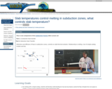
Hands-on demonstrations of advection and diffusion of heat in subduction zones, and …
Hands-on demonstrations of advection and diffusion of heat in subduction zones, and their controls on slab thermal evolution and relationships to melting, using analog models.
This lab exercise provides a hypothetical, regional stratigraphic section for students to …
This lab exercise provides a hypothetical, regional stratigraphic section for students to interpret with regards to depositional environment and tectonic change through time. The assignment is designed to develop and evaluate student scientific writing skills by having students submit a 2-4 page (double-spaced) report detailing the stratigraphic history represented by the section. A primary focus is placed on identifying how and why sedimentary environments change through time and how this change integrates into a broader story of the geologic history for the region in which the section is preserved.
This activity is a field investigation where students will make stream observations …
This activity is a field investigation where students will make stream observations to determine its geologic processes and influence to our local topography.
Understanding the relationship between the outcrop pattern and the 3-D geometry of …
Understanding the relationship between the outcrop pattern and the 3-D geometry of rock bodies is a challenge for students, especially those with low spatial ability. While memorization of learning aids, such as the "rule of V's" can help students interpret structure, it doesn't really help them understand the interaction between topography and rock bodies, and thereby be freed of having to rely on memory aids.
Google Earth offers the ability to view topography in 3D, and in areas of good exposure, the interaction between topography and rock bodies can be clearly visualized by manipulating the viewer's perspective. Through this user interaction, a much clearer understanding of how outcrop patterns related to rock structure can be gained.
(Note: this resource was added to OER Commons as part of a batch upload of over 2,200 records. If you notice an issue with the quality of the metadata, please let us know by using the 'report' button and we will flag it for consideration.)
This module introduces students to subduction zone metamorphism through the examination of …
This module introduces students to subduction zone metamorphism through the examination of rock samples, calculating P-T-t paths, and comparing them to thermal model predictions of P-T paths.
In this activity students develop an hypothesis as how slope morphology reflects …
In this activity students develop an hypothesis as how slope morphology reflects the timing of motion on a fault, in this case the classic Wallace Creek segment of the San Andreas. It is a scaffolded, problem-based exercise that uses ArcGIS and LiDAR data to test their hypothesis.
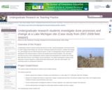
Undergraduate research students working with Deanna van Dijk, a physical geographer and …
Undergraduate research students working with Deanna van Dijk, a physical geographer and faculty member at Calvin College (Grand Rapids, MI), have been monitoring coastal dune processes, variables and changes at a Lake Michigan site from 2000 through the present. To date, 14 undergraduate research students have participated in this research project in summer and academic-year research positions. This case study describes the work of three undergraduate research students who participated from October 2007 through May 2008: Brent Geurink, Luke Pettinga, and Jon Schmitkons. The students participated in setting up and taking down research equipment, making weekly field measurements, data entry, data analysis, and presenting results at a professional conference.
(Note: this resource was added to OER Commons as part of a batch upload of over 2,200 records. If you notice an issue with the quality of the metadata, please let us know by using the 'report' button and we will flag it for consideration.)
In this unit, students engage in a scaffolded class discussion designed to …
In this unit, students engage in a scaffolded class discussion designed to encourage students to move from a broad focus on science relevancy to locally important societal issues relevant to soils. They then relate what they learned during this discussion to the major assessment of this module, the Soils, Systems, and Society Kit (the Kit) assignment, and begin exploring potential focal issues for this assignment. Lastly, the unit introduces concept mapping, and pre-service teachers create a starting concept map for Earth systems, which is a required element of the Kit.
(Note: this resource was added to OER Commons as part of a batch upload of over 2,200 records. If you notice an issue with the quality of the metadata, please let us know by using the 'report' button and we will flag it for consideration.)
This unit introduces students to Structure from Motion (SfM). SfM is a …
This unit introduces students to Structure from Motion (SfM). SfM is a photogrammetric technique that uses overlapping images to construct a 3D model of the scene and has widespread research applications in geodesy, geomorphology, structural geology, and other subfields of geology. SfM can be collected from a hand-held camera or an airborne platform such as an aircraft, tethered balloon, kite, or UAS (unmanned aerial system). After an introduction to the basics of SfM, students will design and conduct their own survey of a geologic feature, followed by an optional (but highly encouraged) introductory exploration of SfM data after returning from the field.
Show more about Online Teaching suggestions Hide Online teaching: This unit was adapted to an online remote field teaching activity. Getting started with Structure from Motion (SfM) photogrammetry (remote field collection).
(Note: this resource was added to OER Commons as part of a batch upload of over 2,200 records. If you notice an issue with the quality of the metadata, please let us know by using the 'report' button and we will flag it for consideration.)
How do geologic, hydrologic, biologic, and built-landscape features manifest themselves on maps? …
How do geologic, hydrologic, biologic, and built-landscape features manifest themselves on maps? In this unit, students will use topographic maps, hillshade maps, and aerial imagery to learn to recognize a variety of landscape features and subsequently identify as many of these features as they can on a map of a new study area. They will also construct a topographic profile from their map data and use their profiles to understand the concepts of slope, aspect, and relief and how these landscape characteristics are important in hazard assessment and land-use planning.
Show more about Online Teaching suggestions Hide Online-adaptable: Part 1 (lecture) and Part 3 (individual or small-group exercise) are particularly straight forward to adapt to online. The landscape scavenger hunt exercise, Part 2, is typically done with printed maps but can be successfully adapted to online by having synchronous groups of students work together to annotate digital map files using: 1) PDF annotation tools in Adobe or 2) putting the map images into a Google Slides file and using the scribble tool. Google Earth files are also provided as an additional option.
(Note: this resource was added to OER Commons as part of a batch upload of over 2,200 records. If you notice an issue with the quality of the metadata, please let us know by using the 'report' button and we will flag it for consideration.)
The basic concepts of geology will be considered to address the widely …
The basic concepts of geology will be considered to address the widely ranging textures and compositions of rocks and sediments formed in a wide range of environments. These variations in turn can affect soil formation and many related Critical Zone processes and architectures. This unit requires substantial reading to cover basic concepts of geology: the rock cycle, plate tectonics, geologic time, erosion, weathering, and deposition, so that students have a firm grasp on how geology relates to and controls CZ processes. This background knowledge is accessed through a review of web sites and a scientific papers. An in-class activity uses the U.S. Geological Survey's National Geologic Map Database to identify resources for understanding and classifying the geology of a region.
(Note: this resource was added to OER Commons as part of a batch upload of over 2,200 records. If you notice an issue with the quality of the metadata, please let us know by using the 'report' button and we will flag it for consideration.)
Unit 3 communicates the critical need for management of fresh water and …
Unit 3 communicates the critical need for management of fresh water and ways in which citizens may take part in its conservation and restoration. Students explore the relationships between watersheds, drainage divides and the hydrologic cycle using a case study from the Hawaiian Islands involving surface water diversions from a region inhabited by indigenous people to a region comprised of large-scale agricultural fields.
(Note: this resource was added to OER Commons as part of a batch upload of over 2,200 records. If you notice an issue with the quality of the metadata, please let us know by using the 'report' button and we will flag it for consideration.)
This introductory geology field exercise asks students to make individual observations about …
This introductory geology field exercise asks students to make individual observations about parts of an outcrop, then combine their observations in larger teams to interpret the overall geological history of the exposure. Content learning includes stratigraphy, faulting, and local geologic history; process learning includes data gathering and recording, hypothesis formation, and outlining helpful evidence that could be gathered in the future.
(Note: this resource was added to OER Commons as part of a batch upload of over 2,200 records. If you notice an issue with the quality of the metadata, please let us know by using the 'report' button and we will flag it for consideration.)
No restrictions on your remixing, redistributing, or making derivative works. Give credit to the author, as required.
Your remixing, redistributing, or making derivatives works comes with some restrictions, including how it is shared.
Your redistributing comes with some restrictions. Do not remix or make derivative works.
Most restrictive license type. Prohibits most uses, sharing, and any changes.
Copyrighted materials, available under Fair Use and the TEACH Act for US-based educators, or other custom arrangements. Go to the resource provider to see their individual restrictions.