Students design and construct devices to trap insects that are present in …
Students design and construct devices to trap insects that are present in the area around the school. The objective is to ask the right design questions and conduct the right tests to determine if the traps work .
This is an investigation where students observe what happens to land after …
This is an investigation where students observe what happens to land after it is mined. Students will create a hypothesis, observe their model, conclude what happens to land after it is mined, and discover the role humans play in land conservation.
Student teams commit to a final decision on the location they recommend …
Student teams commit to a final decision on the location they recommend for safe underground cavern shelter for the citizens of Alabraska. They prepare and deliver final presentations to defend their final decisions to the class.
Students learn about factors that engineers take into consideration when designing buildings …
Students learn about factors that engineers take into consideration when designing buildings for earthquake-prone regions. Using online resources and simulations available through the Earthquakes Living Lab, students explore the consequences of subsurface ground type and building height on seismic destruction. Working in pairs, students think like engineers to apply what they have learned to sketches of their own building designs intended to withstand strong-magnitude earthquakes. A worksheet serves as a student guide for the activity.
Students learn what causes earthquakes, how we measure and locate them, and …
Students learn what causes earthquakes, how we measure and locate them, and their effects and consequences. Through the online Earthquakes Living Lab, student pairs explore various types of seismic waves and the differences between shear waves and compressional waves. They conduct research using the portion of the living lab that focuses primarily on the instruments, methods and data used to measure and locate earthquakes. Using real-time U.S. Geological Survey (USGS) data accessed through the living lab interface, students locate where earthquakes are occurring and how frequently. Students propose questions and analyze the real-world seismic data to find answers and form conclusions. They are asked to think critically about why earthquakes occur and how knowledge about earthquakes can be helpful to engineers. A worksheet serves as a student guide for the activity.
Students learn how engineers characterize earthquakes through seismic data. Then, acting as …
Students learn how engineers characterize earthquakes through seismic data. Then, acting as engineers, they use real-world seismograph data and a tutorial/simulation accessed through the Earthquakes Living Lab to locate earthquake epicenters via triangulation and determine earthquake magnitudes. Student pairs examine seismic waves, S waves and P waves recorded on seismograms, measuring the key S-P interval. Students then determine the maximum S wave amplitudes in order to determine earthquake magnitude, a measure of the amount of energy released. Students consider how engineers might use and implement seismic data in their design work. A worksheet serves as a student guide for the activity.
Students study how geology relates to the frequency of large-magnitude earthquakes in …
Students study how geology relates to the frequency of large-magnitude earthquakes in Japan. Using the online resources provided through the Earthquakes Living Lab, students investigate reasons why large earthquakes occur in this region, drawing conclusions from tectonic plate structures and the locations of fault lines. Working in pairs, students explore the 1995 Kobe earthquake, why it happened and the destruction it caused. Students also think like engineers to predict where other earthquakes are likely to occur and what precautions might be taken. A worksheet serves as a student guide for the activity.
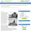
Students examine the effects of geology on earthquake magnitudes and how engineers …
Students examine the effects of geology on earthquake magnitudes and how engineers anticipate and prepare for these effects. Using information provided through the Earthquakes Living Lab interface, students investigate how geology, specifically soil type, can amplify the magnitude of earthquakes and their consequences. Students look in-depth at the historical 1906 San Francisco earthquake and its destruction thorough photographs and data. They compare the 1906 California earthquake to another historical earthquake in Kobe, Japan, looking at the geological differences and impacts in the two regions, and learning how engineers, geologists and seismologists work to predict earthquakes and minimize calamity. A worksheet serves as a student guide for the activity.
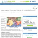
Students gather evidence to explain the theory of plate tectonics. Using the …
Students gather evidence to explain the theory of plate tectonics. Using the online resources at the Earthquakes Living Lab, students examine information and gather evidence supporting the theory. They also look at how volcanoes and earthquakes are explained by tectonic plate movement, and how engineers use this information. Working in pairs, students think like engineers and connect what they understand about the theory of plate tectonics to the design of structures for earthquake-resistance. A worksheet serves as a student guide for the activity.
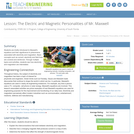
Students are briefly introduced to Maxwell's equations and their significance to phenomena …
Students are briefly introduced to Maxwell's equations and their significance to phenomena associated with electricity and magnetism. Basic concepts such as current, electricity and field lines are covered and reinforced. Through multiple topics and activities, students see how electricity and magnetism are interrelated.
This activity is a field investigation where students make observations of the …
This activity is a field investigation where students make observations of the pebble beach, lava flows, and wetland restoration at Sugarloaf Cove to generate questions to be addressed throughout the earth science curriculum.
In a field investigation to Interstate State Park, students determine lava flow …
In a field investigation to Interstate State Park, students determine lava flow boundaries and observe an ancient rift valley. They also examine differential erosion rates that create a waterfall, and examine the local basalts for evidence of glaciation, including the world-famous potholes.
To understand how fossils are formed, students model the process of fossilization …
To understand how fossils are formed, students model the process of fossilization by making fossils using small toy figures and melted chocolate. They extend their knowledge to the many ways that engineers aid in the study of fossils, including the development of tools and technologies for determining the physical and chemical properties of fossilized organisms, and how those properties tell a story of our changing world.
This activity is a field investigation where students gather geological information of …
This activity is a field investigation where students gather geological information of a designated area and identify the geological features they documented.
This geologic investigation will have students observing and investigating coastal features of …
This geologic investigation will have students observing and investigating coastal features of Western Lake Superior using inquiry-based investigable questions, and inferring possibilities of the coastal features' origins.
This activity is an inquiry-based field investigation of the geologic history of …
This activity is an inquiry-based field investigation of the geologic history of the Minnehaha Falls and St. Anthony Falls areas of Minneapolis. Students will be introduced to rocks and the stories rocks tell in a genuine geologic context, rather than as samples in the classroom.
This activity is a field investigation of the geological features of Minnehaha …
This activity is a field investigation of the geological features of Minnehaha Falls, how they have changed and why, how they are changing and what could be done to preserve the falls.
Short Description: This is an inquiry based field investigation where students gather …
Short Description: This is an inquiry based field investigation where students gather data on the Credit River from the rocks in the river bed, water speed, and maps. Students interpret their findings and develop new questions.
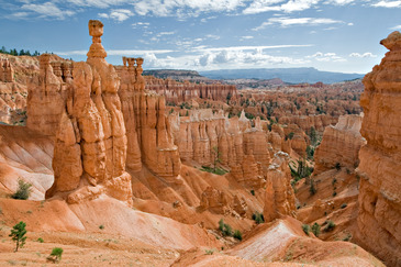
In this culminating activity, students will be assessed on what they have …
In this culminating activity, students will be assessed on what they have learned during the Geology unit of their Earth Science class. After conducting classroom and field studies on geology students will utilize this knowledge to interpret the rock layers and formation of the Grand Canyon. Outside of class students will read/review a website and complete a study guide to be reviewed by the teacher to assess students' learning. Following teacher review of study guides, the next class period(s) will be a discussion and questioning session(s) on the formation of the Grand Canyon.
No restrictions on your remixing, redistributing, or making derivative works. Give credit to the author, as required.
Your remixing, redistributing, or making derivatives works comes with some restrictions, including how it is shared.
Your redistributing comes with some restrictions. Do not remix or make derivative works.
Most restrictive license type. Prohibits most uses, sharing, and any changes.
Copyrighted materials, available under Fair Use and the TEACH Act for US-based educators, or other custom arrangements. Go to the resource provider to see their individual restrictions.