This exercise is designed to simulate how a basic geological investigation of …
This exercise is designed to simulate how a basic geological investigation of a site takes place. A basic geological investigation includes familiarizing yourself with the unconsolidated sediments, rocks, structural geology, and groundwater present at your site. As part of this exercise you will have to properly identify a variety of rock types and sediments, create maps that represent data you collected at each location, and complete a basic report of your findings (optional). Once completed, this exercise should give students a basic understanding of how the various concepts used throughout the semester are applied in the real world in the form of a geological investigation.
(Note: this resource was added to OER Commons as part of a batch upload of over 2,200 records. If you notice an issue with the quality of the metadata, please let us know by using the 'report' button and we will flag it for consideration.)
A virtual landscape is a virtual reality environment designed to develop geologic …
A virtual landscape is a virtual reality environment designed to develop geologic mapping and field skills. They include natural landscapes where the geology can be mapped, and interactive 3D block models of topographic and geological maps. The worlds can be found at www.see.leeds.ac.uk/virtual-landscapes/.
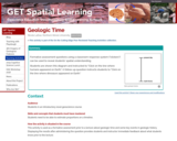
Blank geologic timeline Provenance: Nicole LaDue, Northern Illinois University Reuse: This item …
Blank geologic timeline
Provenance: Nicole LaDue, Northern Illinois University Reuse: This item is offered under a Creative Commons Attribution-NonCommercial-ShareAlike license http://creativecommons.org/licenses/by-nc-sa/3.0/ You may reuse this item for non-commercial purposes as long as you provide attribution and offer any derivative works under a similar license.
Formative assessment questions using a classroom response system ("clickers") can be used to reveal students' spatial understanding.
Students are shown this diagram and instructed to "Click on the line where humans appeared on Earth." A follow-up question instructs students to "Click on the line where dinosaurs appeared on Earth."
(Note: this resource was added to OER Commons as part of a batch upload of over 2,200 records. If you notice an issue with the quality of the metadata, please let us know by using the 'report' button and we will flag it for consideration.)
Short Description: Physical Geology is a comprehensive introductory text on the physical …
Short Description: Physical Geology is a comprehensive introductory text on the physical aspects of geology, including rocks and minerals, plate tectonics, earthquakes, volcanoes, glaciation, groundwater, streams, coasts, mass wasting, climate change, planetary geology and much more. It has a strong emphasis on examples from western Canada, especially British Columbia, and also includes a chapter devoted to the geological history of western Canada. The book is a collaboration of faculty from Earth Science departments at Universities and Colleges across British Columbia and elsewhere.
Long Description: Physical Geology is a comprehensive introductory text on the physical aspects of geology, including rocks and minerals, plate tectonics, earthquakes, volcanoes, glaciation, groundwater, streams, coasts, mass wasting, climate change, planetary geology and much more. It has a strong emphasis on examples from western Canada, especially British Columbia, and also includes a chapter devoted to the geological history of western Canada. The book is a collaboration of faculty from Earth Science departments at Universities and Colleges across British Columbia and elsewhere.
Word Count: 183089
(Note: This resource's metadata has been created automatically as part of a bulk import process by reformatting and/or combining the information that the author initially provided. As a result, there may be errors in formatting.)
This activity utilizes kinestetic learning by having students make models of geologic …
This activity utilizes kinestetic learning by having students make models of geologic concepts, landscapes and processes using playdough in the classroom.
Key words: kinestetic learning, playdough
(Note: this resource was added to OER Commons as part of a batch upload of over 2,200 records. If you notice an issue with the quality of the metadata, please let us know by using the 'report' button and we will flag it for consideration.)
Students are given a short introduction to fossils, strata, Steno's law of …
Students are given a short introduction to fossils, strata, Steno's law of superposition, and the development of the geologic time scale from initial description of systems, through the realization that fossils could be used to correlate between systems, to the assembly of the modern geologic time scale. Then, each student in the course is given a sheet of paper with a simple stratigraphic column and associated fossils representing a geologic system on one side and a short description of the location and history of discovery of the system on the other. On a large wall, students then assemble four geologic columns from their systems representing mainland Europe, Great Britain, the Eastern U.S. and the Western U.S. using the fossils illustrated on their sheets to correlate systems. The instructor guides this process by placing the first system on the wall and by providing some narration as the columns take shape. Europe and Great Britain are assembled first, one sheet at a time, providing when completed the framework of the modern geologic time scale. Once this is up on the wall, the remaining students can assemble the other two columns in minutes using fossils to correlate between American and European systems. A temporal gap in the Grand Canyon sequence provides an opportunity to discuss the incompleteness of the rock record in any one place and a system composed of igneous and metamorphic rocks with no fossils is used to point out the difference between radiometric (absolute) and biostratigraphic (relative) dating.
(Note: this resource was added to OER Commons as part of a batch upload of over 2,200 records. If you notice an issue with the quality of the metadata, please let us know by using the 'report' button and we will flag it for consideration.)
This site from the National Park Service briefly addresses the geology of …
This site from the National Park Service briefly addresses the geology of Devil's Tower. The evolution of various theories on the formation of the tower are discussed. A slide show of the emplacement of the tower is also available.
This is an exercise in which students are reintroduced to geologic maps …
This is an exercise in which students are reintroduced to geologic maps and encouraged to "deconstruct" the map into constituent elements in order to understand the geologic history of the area. The preceding lectures in the course have recapitulated material that the students have covered in Introduction to Physical Geology. During class, the students work through the maps that were part of lab exercises in the Intro level course, so that basic concepts are recalled (superposition, cross-cutting relationships, basic faults and folds). The final product is a geologic history of this map area.
(Note: this resource was added to OER Commons as part of a batch upload of over 2,200 records. If you notice an issue with the quality of the metadata, please let us know by using the 'report' button and we will flag it for consideration.)
This activity is designed to help students recognize the connections among things …
This activity is designed to help students recognize the connections among things like rock identification and map reading with the "story" that these things can tell us in terms of geologic history. Students have already learned about using observation to identify rocks and the principles of interpreting geologic cross-sections. The activity gives students practice in rock ID, topo map reading, geologic map reading and the aspects of geologic time. Students work with rock samples and a geologic map of the Grand Canyon to interpret a history for the area.
(Note: this resource was added to OER Commons as part of a batch upload of over 2,200 records. If you notice an issue with the quality of the metadata, please let us know by using the 'report' button and we will flag it for consideration.)
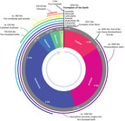
After having talked about the geologic time scale (Precambrian: prior to 570 …
After having talked about the geologic time scale (Precambrian: prior to 570 Ma; Paleozoic: 570-245 Ma; Mesozoic: 245-65 Ma; Cenozoic: 65 Ma - Present), I ask for two volunteers from the class to hold a rope that is 50 feet long. I say that one end is the beginning of the Earth (4.6 billion years ago), and the other is today. I then give out 16 clothes pins and ask various students to put a cloths pin on the 'time line' at various 'geologic events'. For example, I ask them to put one where the dinosaurs died out (end of the Mesozoic). They almost invariably put it much too old (65 Ma is less than 2% of Earth history!). Then I ask them to put one on their birthday (they now laugh). Then I ask them to put one where we think hominoids (humans) evolved (~3-4 Ma), and they realize that we have not been here very long geologically. Then I ask them to put one at the end of the Precambrian, where life took off in terms of the numbers of species, etc. They are amazed that this only represents less than 15% of Earth history. Throughout the activity I have a quiz going on where the students calculate percentages of Earth History for major geologic events, and compare it to their own ages. On their time scale, the dinosaurs died only about two 'months' ago! The exercise is very effective at letting them get a sense of how long geologic time is, and how 'recently' some major geologic events happened when you consider a time scale that is the age of the earth.
(Note: this resource was added to OER Commons as part of a batch upload of over 2,200 records. If you notice an issue with the quality of the metadata, please let us know by using the 'report' button and we will flag it for consideration.)
Word Count: 46737 (Note: This resource's metadata has been created automatically by …
Word Count: 46737
(Note: This resource's metadata has been created automatically by reformatting and/or combining the information that the author initially provided as part of a bulk import process.)
This lab is part of a Lunar and Planetary Geology course offered …
This lab is part of a Lunar and Planetary Geology course offered to both geology and non-geology majors, and it involves basic geological mapping of an area within the Tyrrhena Patera region on Mars. Students are encouraged to work in groups to prepare a geological map from a photomosaic map and to interpret the geologic stratigraphy from a geological map of the greater area. This activity reinforces mapping skills as well as group work skills, and aims to teach students more about Martian stratigraphy and geology through a hands-on activity.
(Note: this resource was added to OER Commons as part of a batch upload of over 2,200 records. If you notice an issue with the quality of the metadata, please let us know by using the 'report' button and we will flag it for consideration.)
An interactive adaptation of Physical Geology, First University of Saskatchewan Edition Short …
An interactive adaptation of Physical Geology, First University of Saskatchewan Edition
Short Description: Physical Geology - H5P Edition is an interactive comprehensive introductory text on the physical aspects of geology, including rocks and minerals, plate tectonics, earthquakes, volcanoes, mass wasting, climate change, planetary geology, and more. It has a strong emphasis on examples from western Canada. It is adapted from Physical Geology, First University of Saskatchewan Edition.
Word Count: 161351
Included H5P activities: 209
(Note: This resource's metadata has been created automatically by reformatting and/or combining the information that the author initially provided as part of a bulk import process.)
This textbook is intended for undergraduate courses in Earth history. It was …
This textbook is intended for undergraduate courses in Earth history. It was written by Callan Bentley, Karen Layou, Russ Kohrs, Shelley Jaye, Matt Affolter, and Brian Ricketts. It is a work in progress.
Word Count: 175133 (Note: This resource's metadata has been created automatically by …
Word Count: 175133
(Note: This resource's metadata has been created automatically by reformatting and/or combining the information that the author initially provided as part of a bulk import process.)
Assemble a regional geologic history by compiling observations made a several sites. …
Assemble a regional geologic history by compiling observations made a several sites.
(Note: this resource was added to OER Commons as part of a batch upload of over 2,200 records. If you notice an issue with the quality of the metadata, please let us know by using the 'report' button and we will flag it for consideration.)
This Historical Geology lab exercise is an accompaniment to lab class instruction …
This Historical Geology lab exercise is an accompaniment to lab class instruction about geologic structures (folding and faulting) and geologic maps. It also serves as an excellent introduction to the Geology of the state of Texas. "Coloring" geologic maps, an important part of the exercise, may seem like a very elementary learning technique. But this lab engages students actively, and since the subject is often already somewhat familiar to them, emphasizing both the geology and geography of Texas, students receive it enthusiastically.
This activity could be adapted to other regions, since most states have color 8 1/2 by 11 geologic maps available. A color map could be scanned and modified in Photoshop to create a simplified black and white version as was done in the assignment handout.
(Note: this resource was added to OER Commons as part of a batch upload of over 2,200 records. If you notice an issue with the quality of the metadata, please let us know by using the 'report' button and we will flag it for consideration.)
This observational inquiry activity involving careful descriptions of rocks and fossil including …
This observational inquiry activity involving careful descriptions of rocks and fossil including age will be used to create a scalar accurate geologic time scale. Students will observe and learn that the geologic time scale was created based on changes in fossil, rock, and atmospheric changes.
Short Description: Physical Geology is a comprehensive introductory text on the physical …
Short Description: Physical Geology is a comprehensive introductory text on the physical aspects of geology, including rocks and minerals, plate tectonics, earthquakes, volcanoes, glaciation, groundwater, streams, coasts, mass wasting, climate change, planetary geology and much more. It has a strong emphasis on examples from western Canada, especially British Columbia, and also includes a chapter devoted to the geological history of western Canada. The book is a collaboration of faculty from Earth Science departments at Universities and Colleges across British Columbia and elsewhere.
Long Description: Physical Geology is a comprehensive introductory text on the physical aspects of geology, including rocks and minerals, plate tectonics, earthquakes, volcanoes, glaciation, groundwater, streams, coasts, mass wasting, climate change, planetary geology and much more. It has a strong emphasis on examples from western Canada, especially British Columbia, and also includes a chapter devoted to the geological history of western Canada. The book is a collaboration of faculty from Earth Science departments at Universities and Colleges across British Columbia and elsewhere.
Word Count: 196144
ISBN: 978-1-77420-028-5
(Note: This resource's metadata has been created automatically by reformatting and/or combining the information that the author initially provided as part of a bulk import process.)
No restrictions on your remixing, redistributing, or making derivative works. Give credit to the author, as required.
Your remixing, redistributing, or making derivatives works comes with some restrictions, including how it is shared.
Your redistributing comes with some restrictions. Do not remix or make derivative works.
Most restrictive license type. Prohibits most uses, sharing, and any changes.
Copyrighted materials, available under Fair Use and the TEACH Act for US-based educators, or other custom arrangements. Go to the resource provider to see their individual restrictions.