In Malaysia there is an island known for more sea turtles than …
In Malaysia there is an island known for more sea turtles than virtually anywhere on Earth. In this video, Jonathan visits this amazing ecosystem to learn about the life cycle of sea turtles. He is surprised to discover an amazingly complex and competitive environment. Please see the accompanying study guide for educational objectives and discussion points.
Charles Kennel explores how the convergence of earth science, biology, and social …
Charles Kennel explores how the convergence of earth science, biology, and social science through the use of information technology can lead to continuous awareness of Earth's systems, enabling coordinated responses to the global environmental challenges that face us now and in the future. (58 minutes)
The video is a procedural guide to sampling salinity measurements in water …
The video is a procedural guide to sampling salinity measurements in water bodies in the field. It provides a step-by-step explanation of field procedures and features students conducting the investigation and asking questions about what changes in salinity could indicate in rivers, lakes, and estuaries. The resource includes a video, transcript, and is supported by the Salinity Protocol in the GLOBE Teacher's Guide. This is one of seven videos on hydrology in the 24-part instructional video series describing scientific protocols used by GLOBE (Global Learning and Observation to Benefit the Environment), a worldwide, hands-on, K-12 school-based science education program.
Interactive online tutorial about growing urchin larvae in a lab setting. Students …
Interactive online tutorial about growing urchin larvae in a lab setting. Students manipulate data and are led through a lab-based situation. There is a module on ocean acidification. Lesson plans can be downloaded from website.
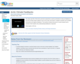
This video uses film of the Arctic and Arctic researchers as well …
This video uses film of the Arctic and Arctic researchers as well as animations to discuss feedbacks in the Arctic climate system related to sea ice, the ocean, and clouds. It explains concepts such as albedo and positive and negative feedbacks. The narrative includes discussion of current research and a summary which explains why understanding feedbacks is important.
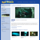
Deep underneath MexicoŰŞs Yucatan peninsula, underground rivers wind their way to the …
Deep underneath MexicoŰŞs Yucatan peninsula, underground rivers wind their way to the sea. In some places, the forest floor has fallen in, leaving holes in the ground to access these mysterious underwater caves. The holes, called cenotes, were considered openings to the underworld by the ancient Mayans. In this video, Jonathan teams up with an expert cave diver to explore these spooky underground rivers. Please see the accompanying lesson plan for educational objectives, discussion points and classroom activities.
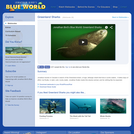
In this video, Jonathan travels to Canada in search of the Greenland …
In this video, Jonathan travels to Canada in search of the Greenland shark, a huge, lethargic shark that lives in arctic waters. It takes days of effort, but finally, in dark, cold, murky water, Jonathan finally meets this elusive animal, and it's nothing like he expected. Please see the accompanying study guide for educational objectives and discussion points.
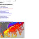
Oceans play a significant role in determining and moderating the effects of …
Oceans play a significant role in determining and moderating the effects of energy imbalances. Students will begin this lesson by working with temperature data to reinforce the importance of protocols, practice computing statistical measures of data and interpreting their significance. The lesson continues with investigations into daily and annual energy cycles. Using a sea surface environment visualizer, students then identify patterns of sea surface current and temperature data. Note that this is lesson five of five on the Ocean Motion website. Each lesson investigates ocean surface circulation using satellite and model data and can be done independently. See Related URL's for links to the Ocean Motion Website that provide science background information, data resources, teacher material, student guides and a lesson matrix.
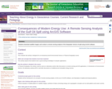
This laboratory activity takes place in a computer lab that is equipped …
This laboratory activity takes place in a computer lab that is equipped with ArcGIS (we are currently using ArcGIS 9.3). Students will go to NASA's oil spill gallery website and download the full size image of the Deepwater Horizon oil slick from July 14th, 2010 taken by the Moderate Resolution Imaging Spectroradiometer (MODIS) on NASA's Aqua satellite at 1:55 p.m. Central Daylight Time. Their task is to to analyze the satellite imagery as an RGB composite and to experiment with reclassification techniques to subdivide the continuous raster dataset into user-defined numbers of ranges that will help visualize the oil spill. The activity introduces students to GIS software, remote sensing analysis, and sets up questions on spatial patterns and consequences of energy use.
(Note: this resource was added to OER Commons as part of a batch upload of over 2,200 records. If you notice an issue with the quality of the metadata, please let us know by using the 'report' button and we will flag it for consideration.)
For more than twenty years, people have been feeding a large group …
For more than twenty years, people have been feeding a large group of friendly stingrays at a place in the Cayman Islands. In this video, Jonathan travels to Grand Cayman to meet up with the famous marine artist and researcher Dr. Guy Harvey who is studying the relationship between humans and stingrays. He even shows Jonathan how to hold a stingray safely in his arms. Please see the accompanying study guide for educational objectives and discussion points.
In this problem-based learning (PBL) scenario, students prepare a presentation for investors …
In this problem-based learning (PBL) scenario, students prepare a presentation for investors showing how their fishing company has a significant advantage because it locates upwelling zones and fishing areas using TRMM (Tropical Rainfall Measuring Mission) and other satellite data. Prior to launching the PBL, students learn about wind: the topics of air pressure, coriolis effect, upwelling and the role of differential heating on the atmosphere are explored in classroom demonstrations. Materials required include a beaker, coffee grounds, drinking straw, balloon, flashlight, and turntable. The resource includes teacher background information, glossary, assessment rubric, and an appendix introducing problem-based learning.
In this video, Jonathan treks all the way to Antarctica to investigate …
In this video, Jonathan treks all the way to Antarctica to investigate life south of the polar circle. Along the way he dives in the majestic kelp forests of Patagonia, where crabs rule the sea floor. Once he arrives in Antarctica, his adventures continue. He swims with penguins, dives under an iceberg, meets a massive jellyfish 3 feet across, and has an incredible encounter with a Leopard seal, the apex predator of Antarctica. Part 2 finds Jonathan continuing his exploration of Antarctica including an encounter with a Leopard seal. This program won a New England Emmy Award! Please see the accompanying lesson plan for educational objectives, discussion points and classroom activities.
In this activity, students conduct a short hands-on demonstration that simulates ocean …
In this activity, students conduct a short hands-on demonstration that simulates ocean acidification resulting from excess atmospheric carbon dioxide and discuss potential implications of increases in ocean temperatures and acidification due to climate change.
Storms can have devastating impacts on coastal communities. Typically, tropical storms like …
Storms can have devastating impacts on coastal communities. Typically, tropical storms like hurricanes get the most attention, but there are other types of storms that occur at more northern latitudes that can be just as destructive. For example, in January of 2018, Winter Storm Grayson caused more than 300,000 power outages and $1.1 billion in damage, and resulted in 22 confirmed casualties along the eastern seaboard. In this module, students will learn how barometric pressure changes during a storm, analyze the effect of storms on oceanographic variables, classify a storm as a bomb cyclone, and compare a bomb cyclone to a hurricane. Ultimately students will use their quantitative reasoning skills to manipulate and visualize data during storms in the northeastern United States.
(Note: this resource was added to OER Commons as part of a batch upload of over 2,200 records. If you notice an issue with the quality of the metadata, please let us know by using the 'report' button and we will flag it for consideration.)
Aquatic ecosystems are home to a complex intersection of physical and biological …
Aquatic ecosystems are home to a complex intersection of physical and biological factors and an intersection of natural and anthropogenic factors. In the Chesapeake Bay, low oxygen events have occurred periodically and may be connected with harmful algal blooms, fish kills, heavy flooding/runoff events, and warming temperatures. Careful monitoring of the system by the Chesapeake Bay Program since 1984 allows scientists and policymakers to evaluate the causes of the events and monitor improvements in the health of the ecosystem.
(Note: this resource was added to OER Commons as part of a batch upload of over 2,200 records. If you notice an issue with the quality of the metadata, please let us know by using the 'report' button and we will flag it for consideration.)
This activity introduces students to using Google Earth and adding layers to …
This activity introduces students to using Google Earth and adding layers to google earth, while re-enforcing plate tectonic concepts and evidence for plate tectonics. Outcomes: 1. Download Google Earth onto computer 2. Turn on/off layers within Google Earth 3. Be able to change measurement and use ruler within Google Earth 4. Determine latitude and longitude of ocean basin features 5. Be able to search for locations within Google Earth 6. Learn to upload new layers into Google Earth from .kmz files 7. Describe different plate boundaries, their locations and boundary interactions 8. Explain evidence for Plate Tectonics
This is a hands-on lab activity about the properties and states of …
This is a hands-on lab activity about the properties and states of water. Learners will complete activities using different liquids to understand the three states of matter, explain how the high heat capacity and abundance of liquid water makes life on Earth possible, and understand that water containing salts and minerals has different properties than fresh water. They will graph data to analyze and articulate results and conclusions. The lab is set up as three stations that small groups of students rotate through; it can also be done as demonstrations (e.g., for younger students). Background information, common preconceptions, a glossary and more is included. This activity is part of the Aquarius Hands-on Laboratory Activities.
This video introduces the measurement of dissolved oxygen in a water body …
This video introduces the measurement of dissolved oxygen in a water body as an important indicator of ecosystem health, and demonstrates students analyzing a water sample for dissolved oxygen. The resource includes a video and a written transcript, and is supported by the Dissolved Oxygen Protocol in the GLOBE Teacher's Guide. This is one of seven videos on hydrology in the 24-part instructional video series describing scientific protocols used by GLOBE (Global Learning and Observation to Benefit the Environment), a worldwide, hands-on, K-12 school-based science education program.
This is a full color, worldwide, animated weather map using GIS interface …
This is a full color, worldwide, animated weather map using GIS interface showing current and projected wind and other weather conditions for any location in the world. Data can be viewed at different spatial scales.
The video is a procedural guide to sampling electrical conductivity measurements in …
The video is a procedural guide to sampling electrical conductivity measurements in water bodies using standardized GLOBE protocols. It provides a step-by-step explanation of the field procedure and features students conducting the investigation and asking questions about measuring electrical conductivity and what these measurements mean with respect to water impurities and dissolved solids. The resource includes a video, transcript, and is supported by the Electrical Conductivity Protocol in the GLOBE Teacher's Guide. This is one of seven videos on hydrology in the 24-part instructional video series describing scientific protocols used by GLOBE (Global Learning and Observation to Benefit the Environment) a worldwide, hands-on, K-12 school-based science education program.
No restrictions on your remixing, redistributing, or making derivative works. Give credit to the author, as required.
Your remixing, redistributing, or making derivatives works comes with some restrictions, including how it is shared.
Your redistributing comes with some restrictions. Do not remix or make derivative works.
Most restrictive license type. Prohibits most uses, sharing, and any changes.
Copyrighted materials, available under Fair Use and the TEACH Act for US-based educators, or other custom arrangements. Go to the resource provider to see their individual restrictions.