Unit 2 engages students in topics related to the water cycle, both …
Unit 2 engages students in topics related to the water cycle, both from natural and urban system perspectives. Students are assigned approximately 30 minutes of reading (short article) and are required to watch a 15-minute video before class to gain a basic understanding of the natural and urban water cycles, their components, and the impact of urbanization on runoff. Through short lectures, discussion questions, solution to example problems, and a group activity, students gain comprehension of the water cycle components, their spatial and temporal variability, water budget calculation, and the impacts of urbanization on surface water.
(Note: this resource was added to OER Commons as part of a batch upload of over 2,200 records. If you notice an issue with the quality of the metadata, please let us know by using the 'report' button and we will flag it for consideration.)
Unit 2 opens a window into water accounting and reveals intensive water …
Unit 2 opens a window into water accounting and reveals intensive water use that few people think about. How much water goes into common commodities? Have you considered how much water it takes to support our modern American lifestyle and agricultural trade? Water that is embedded in products and services is called virtual water. Looking at the world through the lens of virtual water provides a watery focus to thorny discussions about water such as: the pros and cons of globalization and long distance trade; self sufficiency vs. reliance on other nations; ecosystem impacts of exports; and the impacts of relatively cheap imports on indigenous farming. Unit 2 also introduces the concept of a water footprint. A water footprint represents a calculation of the volume of water needed for the production of goods and services consumed by an individual or country. In this unit students will calculate their individual footprints and analyze how the water footprints of countries vary dramatically in terms of gross volumes and their components. As a result of these activities, students will learn of vast disparities in water access and application. They will also be challenged to consider mechanisms or policies that could foster greater equity in water footprints.
(Note: this resource was added to OER Commons as part of a batch upload of over 2,200 records. If you notice an issue with the quality of the metadata, please let us know by using the 'report' button and we will flag it for consideration.)
In this activity, the student groups organized at the end of Unit …
In this activity, the student groups organized at the end of Unit 3.1 will prepare presentations representing different stakeholder positions. This artifact -- Part I of the Module Summative Assessment (Microsoft Word 2007 (.docx) 25kB Sep4 16) -- can be part of a presentation to the instructor, to a panel of faculty/students, or to a "board" representing some decision-making unit (Community Council, University Board of Trustees, City/County Planning Commission). At the conclusion of this unit, students will be prompted to reflect, individually, on an ecosystem services approach to natural resources management -- Part II of the Module Summative Assessment (Microsoft Word 2007 (.docx) 23kB Sep4 16) .
(Note: this resource was added to OER Commons as part of a batch upload of over 2,200 records. If you notice an issue with the quality of the metadata, please let us know by using the 'report' button and we will flag it for consideration.)
This unit presents an applied Case Study example and the associated concepts …
This unit presents an applied Case Study example and the associated concepts related to designing a seismic survey and analyzing the data. Parts of the instrument are discussed and practical experience simulating travel time arrivals on a travel time-offset plot are presented. A real dataset from the Case Study site at Codorus Creek, York, PA is presented and analysis strategies are discussed.
(Note: this resource was added to OER Commons as part of a batch upload of over 2,200 records. If you notice an issue with the quality of the metadata, please let us know by using the 'report' button and we will flag it for consideration.)
This unit is designed to allow students to quantitatively assess how much …
This unit is designed to allow students to quantitatively assess how much water is used for irrigating crops and how this varies across the United States. This unit also has students link water use to the economic value of the crops that are produced--spanning the scientific and economic disciplines. The concepts that students learn here will connect back to the Water Footprint concept that was introduced in Unit 2, as students consider the accuracy of water calculators.
(Note: this resource was added to OER Commons as part of a batch upload of over 2,200 records. If you notice an issue with the quality of the metadata, please let us know by using the 'report' button and we will flag it for consideration.)
Over the course of one week, students will apply and evaluate concepts …
Over the course of one week, students will apply and evaluate concepts in the context of their local community, culminating in the formulation and evaluation of Hazard Mitigation Plan recommendations presented in stakeholder position papers. These position papers, which will also serve as the summative assessment of the Major Storms and Community Resilience Module, will be presented and assessed during a Town Hall Meeting. In this role-playing activity, students apply and evaluate concepts in the context of assigned stakeholder positions from their local community. Over the course of the week, students formulate and evaluate Hazard Mitigation Plan recommendations for major storms, and then present those recommendations in a town hall-style meeting. These assignments demonstrate students' ability to develop strategies and recommendations to mitigate local community vulnerabilities to storms with specific emphasis on different sectors and/or stakeholders in that community. Instructors will assess student achievement of the learning goals through a formal oral presentation and a team policy position paper. As such, the culmination of Unit 3 in the Town Hall Meeting serves as the summative assessment for the Major Storms module.
(Note: this resource was added to OER Commons as part of a batch upload of over 2,200 records. If you notice an issue with the quality of the metadata, please let us know by using the 'report' button and we will flag it for consideration.)
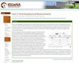
Near surface geophysical measurements are performed by moving sensors across the Earth's …
Near surface geophysical measurements are performed by moving sensors across the Earth's surface. Active geophysical sensors transmit a signal into the Earth and record a returned signal that contains information on the physical and chemical properties of the Earth (see Unit 2). This unit introduces the student to the basics of geophysical data acquisition using two techniques that record variations in the electrical conductivity (see Unit 2) of the Earth: [1] electrical imaging (EI), and [2] electromagnetic (EM) conductivity mapping.
Basic concept of electrical imaging measurements
Provenance: Lee Slater, Rutgers University-Newark Reuse: This item is in the public domain and maybe reused freely without restriction. Electrical imaging is a galvanic geophysical approach whereby electrical contact with the Earth is made directly via electrodes (typically metal stakes) that are inserted into the ground. Electromagnetic conductivity mapping is a non-contact approach whereby the physics of EM induction is used to sense changes in electrical conductivity. The advantages and disadvantages of using galvanic (EI) and non-contact (EM) techniques for measuring electrical conductivity are described. Ohm's Law is introduced and students investigate how electrical resistance measurements are related to the electrical conductivity of soils. Field implementation of both EI and EM techniques is demonstrated using surveys performed in Harrier Meadow as an example. Students investigate how variations in survey configuration parameters (e.g. electrode configuration and electrode spacing in EI, frequency and coil spacing in EM) control investigation depth (how far into the ground the signals sense) and spatial resolution (what size objects can be detected). The concept of pre-modeling a geophysical survey (i.e. running some simulations of likely effectiveness of the methods before going to the field) to evaluate expected investigation depth and sensitivity is introduced. The Excel-based Scenario Evaluator for Electrical Resistivity (SEER) tool provided by the United States Geological Survey (USGS) is used to demonstrate some key concepts.
(Note: this resource was added to OER Commons as part of a batch upload of over 2,200 records. If you notice an issue with the quality of the metadata, please let us know by using the 'report' button and we will flag it for consideration.)
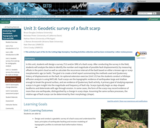
In this unit, students will design a survey (TLS and/or SfM) of …
In this unit, students will design a survey (TLS and/or SfM) of a fault scarp. After conducting the survey in the field, students will analyze the data to identify the number and magnitude of possible fault displacement(s) by measuring offsets in the point cloud as well as calculate the recurrence interval of the fault based on either a known age or scarp morphometric age (or both). The goal is to create a brief report summarizing the methods used and Quaternary history of displacements on the fault. An optional extension exercise (Unit 3.5) has the students conduct a hillslope diffusion analysis is using MATLAB. Fault scarps are the topographic evidence of earthquakes large and shallow enough to break the ground surface, and are evidence of Quaternary fault activity. A primary goal of studying exposed scarps is to gain insight into the magnitude and frequency of fault slip. Scarps typically begin as step-shaped landforms and deteriorate with age through erosion. In some cases, the form of the scarp may record evidence of more than one earthquake, distinguished by a change in scarp slope. Assuming the same surface processes, the relative age of fault scarps can be determined by their morphology (shape).
(Note: this resource was added to OER Commons as part of a batch upload of over 2,200 records. If you notice an issue with the quality of the metadata, please let us know by using the 'report' button and we will flag it for consideration.)
Bruce Douglas (Indiana University)
Nicholas Pinter (University of California Davis)
Nathan Niemi (University of Michigan)
J. Ramon Arrowsmith (Arizona State University)
Kate Shervais (UNAVCO)
Chris Crosby (UNAVCO)
Students will be introduced to a few of the different methods used …
Students will be introduced to a few of the different methods used in paleoclimatology, including isotopic ratios as paleotemperature proxies. They will investigate the greenhouse gas connections of two ancient climate episodes, the cold "Snowball Earth" of the Neoproterozoic and the hot "Paleocene-Eocene Thermal Maximum" (PETM) of the Cenozoic. The unit emphasizes the grand challenges of energy resources and climate change by grounding these issues in an understanding of ancient climate from a systems thinking perspective. Students will gain a more robust appreciation for the record of the movement of carbon between atmosphere, geosphere, hydrosphere, and biosphere over geologic time, and how various components of the Earth system respond to those perturbations. The unit practices geoscientific habits of mind, such as comparing modern processes to ancient analogues recorded by geologic processes, as well as the importance of converging lines of evidence, and recognition of Earth as a long-lived, dynamic, and complex system.
(Note: this resource was added to OER Commons as part of a batch upload of over 2,200 records. If you notice an issue with the quality of the metadata, please let us know by using the 'report' button and we will flag it for consideration.)
This unit provides essential background information on GPS (global positioning system) and …
This unit provides essential background information on GPS (global positioning system) and reference frames. Students learn how to access GPS location and velocity data from the Network of the Americas (NOTA). They calculate total horizontal motion graphically and mathematically and tie the observed motions to local strain.
Show more information on GPS versus GNSS Hide Note: Although the term GPS (Global Positioning System) is more commonly used in everyday language, it officially refers only to the USA's constellation of satellites. GNSS (Global Navigation Satellite System) is a universal term that refers to all satellite navigation systems including those from the USA (GPS), Russia (GLONASS), European Union (Galileo), China (BeiDou), and others. In this module, we use the term GPS even though, technically, some of the data may be coming from satellites in other systems.
Show more about Online Teaching suggestions Hide Online-ready: The exercise is electronic (including accessing an online data portal) and could be done individually or in small online groups. Lecture can be done in synchronous or asynchronous online format.
(Note: this resource was added to OER Commons as part of a batch upload of over 2,200 records. If you notice an issue with the quality of the metadata, please let us know by using the 'report' button and we will flag it for consideration.)
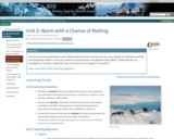
What is the contribution of melting ice sheets compared to other sources …
What is the contribution of melting ice sheets compared to other sources of sea-level rise? How much is the sea level projected to increase during the twenty-first century? In this unit students will use Gravity Recovery and Climate Experiment (GRACE) ice-mass loss time series from Greenland and Antarctica to calculate sea-level rise due to the addition of freshwater inputs from melting ice sheets, and use Interferometric Synthetic Aperture Radar (InSAR) ice-velocity data to extrapolate which regions of the ice sheets are losing the greatest mass. Sea-level rise from melting ice sheets is then contrasted to the other dominant causes of sea-level rise, including thermal expansion, melting glaciers, and changes in land water storage. Lastly, students will extrapolate how much sea-level rise will occur by year 2100 based on recent observed rates of sea-level rise and compare these values to sea-level rise projections from the Intergovernmental Panel on Climate Change.
Show more about Online Teaching suggestions Hide Online-ready: The exercise is electronic and could be done individually or in small online groups. Lecture is best done synchronously due to the technical nature. Discussion would be better that way too.
(Note: this resource was added to OER Commons as part of a batch upload of over 2,200 records. If you notice an issue with the quality of the metadata, please let us know by using the 'report' button and we will flag it for consideration.)
This unit introduces systems modeling, which allows students to quantify and manipulate …
This unit introduces systems modeling, which allows students to quantify and manipulate system components to create system responses. Students use a simple systems model of a bathtub to explore the effect of flow rates on system equilibrium. To complete the unit, students will need a method for creating and sharing diagrams (whiteboards, posters, etc.), and will ideally have access to free systems modeling software.
(Note: this resource was added to OER Commons as part of a batch upload of over 2,200 records. If you notice an issue with the quality of the metadata, please let us know by using the 'report' button and we will flag it for consideration.)
How do slope characteristics and magnitude of forces dictate whether or not …
How do slope characteristics and magnitude of forces dictate whether or not a slope will fail? Can environmental and built characteristics change the magnitude of these forces? In this unit, students qualitatively and quantitatively consider the impact of slope angle, driving force, and frictional force on mass-wasting potential. A map activity prompts students to think about how climatic, tectonic, and geologic factors, as well as population and land use characteristics can influence mass-wasting potential.
Show more about Online Teaching suggestions Hide Online-adaptable: Part 1 (lecture) and Part 3 (discussion) are particularly straight forward to adapt to online. Part 2 student exercise is typically done with printed maps but can be successfully adapted to online by having synchronous groups of students work together to annotate digital map files using: 1) PDF annotation tools in Adobe or 2) putting the map images into a Google Slides file and using the scribble tool. Google Earth files are also provided as an additional option.
(Note: this resource was added to OER Commons as part of a batch upload of over 2,200 records. If you notice an issue with the quality of the metadata, please let us know by using the 'report' button and we will flag it for consideration.)
Unit 3 addresses concepts related to urban-atmosphere interactions. The content explores how …
Unit 3 addresses concepts related to urban-atmosphere interactions. The content explores how urban landscapes and atmospheric constituents modify or interact with the atmosphere to affect temperature, clouds, rainfall, and other parts of the water cycle. Fundamental concepts of weather and climate are established. The unit then transitions to focus on the "urbanized" environment and its complex interactions with the atmosphere. Students will learn about interactions such as 1) urban modification of surface temperature and energy exchanges; 2) water cycle components; 3) cloud-rainfall evolution within urban environments; and 4) applications to real societal challenges like urban flooding. The unit integrates basic meteorological/climatological analyses, geospatial thinking, and integration of scientific concepts within a real world context.
(Note: this resource was added to OER Commons as part of a batch upload of over 2,200 records. If you notice an issue with the quality of the metadata, please let us know by using the 'report' button and we will flag it for consideration.)
How are recent air temperature trends influencing Greenland's ice mass? Are ice …
How are recent air temperature trends influencing Greenland's ice mass? Are ice mass changes in Greenland spatially and temporally uniform? In this unit, students use atmospheric and geodetic data (GRACE, InSAR, altimetry) to investigate the location, magnitude, and causes of ice mass changes in Greenland.
Show more about Online Teaching suggestions Hide Online-adaptable:Main exercise is a jigsaw activity that can be successfully done in an online course; but it does take a bit of extra effort to arrange the students into two different sets of online groups with online collaboration. This will probably be more success in a synchronous format. OR the unit could be adapted away from the jigsaw format with Parts 2 and 3 below combined into a single exercise done individually or in static small groups.
(Note: this resource was added to OER Commons as part of a batch upload of over 2,200 records. If you notice an issue with the quality of the metadata, please let us know by using the 'report' button and we will flag it for consideration.)
The purpose of this unit is to explore, compare, contrast, and calculate …
The purpose of this unit is to explore, compare, contrast, and calculate energy fluxes from different CZO field sites to better appreciate the critical differences in the driving radiative forces affecting each site. This module will help students complete their semester-long project by introducing them to critical baseline data collection and databases related to energy budgets. The primary data set for this activity is the CZO tower network of a dozen met/flux towers spanning six different biomes/sites. Each site has a slightly different data format but it is easily manipulated in a spreadsheet. The lesson is divided into the following engaging activities:
Background lecture: Introduction to water and energy fluxes and balances Database access and graphing activity: Students will learn what data exists in the CZO database and how to load and manipulate it using Excel. Discovery activity: Students in small groups will compare monthly bar graphs of energy fluxes drawn from six Ameriflux sites and address questions concerning linkages with other variables and processes affecting energy partitioning. Reference ET Activity: Students will learn about the Penman-Monteith formulation of evaporation and calculate this from common meteorological data and compare with field measurements of evapotranspiration. The class will discuss these results as time allows.
(Note: this resource was added to OER Commons as part of a batch upload of over 2,200 records. If you notice an issue with the quality of the metadata, please let us know by using the 'report' button and we will flag it for consideration.)
The purpose of this unit is to explore, compare, contrast, and interpret …
The purpose of this unit is to explore, compare, contrast, and interpret carbon fluxes from the Ameriflux network to better appreciate the critical factors that account for the different timing and magnitudes of fluxes among these sites. This module will help students complete their semester-long project by introducing them to critical baseline data collection and databases related to carbon budgets. The primary data set for this activity is the Amerflux network database, which spans over 150 sites throughout the Americas. Each data set is uniformly formatted and can contain up to 45 fields of meteorological and flux data collected from various eddy correlation tower instruments. The lesson is divided up between the following engaging activities:
Background lecture: Introduction to carbon fluxes and balances Discovery Activity: Students in small groups will compare various annual flux records from four different sites to address questions regarding driving variables, correlation among variables, and causative factors responsible for the overall trend in annual CO2 flux. Group results will be shared and discussed by the whole class as time allows. Database Access Activity: Students will learn what data exists in the Ameriflux data base and how to load it into an Excel spreadsheet for display using an Amerflux site that also is part of the CZO network. Carbon Flux Hypothesis Activity: Students will develop a simple hypothesis regarding the timing and/or magnitude of CO2 fluxes and use data from the Ameriflux database to support their ideas.
(Note: this resource was added to OER Commons as part of a batch upload of over 2,200 records. If you notice an issue with the quality of the metadata, please let us know by using the 'report' button and we will flag it for consideration.)
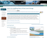
How much and how quickly does Earth's surface respond to changes in …
How much and how quickly does Earth's surface respond to changes in a glacier's mass? How can geodesy help scientists understand the relationship between ice mass change and changes in the bedrock surface? How are these processes related to regional sea level changes? In this unit, students use visualizations, bedrock GPS (Global Positioning System), and ice elevation data from Greenland's Helheim Glacier to investigate the concept of post-glacial rebound and the relative contributions of rebound and ice melting to regional sea level changes in Greenland.
Show more information on GPS versus GNSS Hide Note: Although the term GPS (Global Positioning System) is more commonly used in everyday language, it officially refers only to the USA's constellation of satellites. GNSS (Global Navigation Satellite System) is a universal term that refers to all satellite navigation systems including those from the USA (GPS), Russia (GLONASS), European Union (Galileo), China (BeiDou), and others. In this module, we use the term GPS even though, technically, some of the data may be coming from satellites in other systems.
Show more about Online Teaching suggestions Hide Online-adaptable: The lecture and main data analysis exercise can easily be moved online. The final piece is a discussion or [linkhttps://serc.carleton.edu/introgeo/gallerywalk/index.html 'gallery walk'] which can also be successfully done online but may take a little more preparation. For instance, in the case of the gallery walk, the images and questions can be available for online viewing with space available for student comments. Online groups then rotate through the stations virtually.
(Note: this resource was added to OER Commons as part of a batch upload of over 2,200 records. If you notice an issue with the quality of the metadata, please let us know by using the 'report' button and we will flag it for consideration.)
Feedbacks are a critical part of many systems. In this unit, students …
Feedbacks are a critical part of many systems. In this unit, students use a systems model to explore the effect of positive (reinforcing) and negative (balancing) feedbacks on system behavior. Model results are then used as a basis for interpreting Arctic sea ice data. To complete the unit, students will ideally have access to free systems modeling software.
(Note: this resource was added to OER Commons as part of a batch upload of over 2,200 records. If you notice an issue with the quality of the metadata, please let us know by using the 'report' button and we will flag it for consideration.)
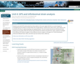
Students work with GPS velocity data from three stations in the same …
Students work with GPS velocity data from three stations in the same region that form an acute triangle. By investigating how the ellipse inscribed within this triangle deforms, students learn about strain, strain ellipses, GPS, and how to tie these to regional geology and ongoing hazards. This unit contains the primary infinitesimal strain analysis for the module. After the instructor demonstrates the method using data from Japan, students investigate three different GPS station triangles in three difference tectonic regimes: convergent (U.S. Pacific Northwest), extensional (Wasatch fault, Utah), and strike-slip (San Andreas Fault, California).
Show more information on GPS versus GNSS Hide Note: Although the term GPS (Global Positioning System) is more commonly used in everyday language, it officially refers only to the USA's constellation of satellites. GNSS (Global Navigation Satellite System) is a universal term that refers to all satellite navigation systems including those from the USA (GPS), Russia (GLONASS), European Union (Galileo), China (BeiDou), and others. In this module, we use the term GPS even though, technically, some of the data may be coming from satellites in other systems.
Show more about Online Teaching suggestions Hide Online-ready: The exercise is electronic (including accessing an online data portal) and could be done individually or in small online groups. Lecture can be done in synchronous or asynchronous online format.
(Note: this resource was added to OER Commons as part of a batch upload of over 2,200 records. If you notice an issue with the quality of the metadata, please let us know by using the 'report' button and we will flag it for consideration.)
No restrictions on your remixing, redistributing, or making derivative works. Give credit to the author, as required.
Your remixing, redistributing, or making derivatives works comes with some restrictions, including how it is shared.
Your redistributing comes with some restrictions. Do not remix or make derivative works.
Most restrictive license type. Prohibits most uses, sharing, and any changes.
Copyrighted materials, available under Fair Use and the TEACH Act for US-based educators, or other custom arrangements. Go to the resource provider to see their individual restrictions.