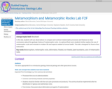
Average inquiry level: Structured In this lab, students will use observations to …
Average inquiry level: Structured In this lab, students will use observations to compare and contrast metamorphic processes and features to draw conclusions about the geologic history of metamorphic rocks. As optional final work, students further explore the use of metamorphic rocks and minerals in modern life and aspects related to human health. This lab is designed for face-to-face instruction. Key words:Metamorphism, metamorphic rocks, deformation, foliated, non foliated, plate boundaries, uses of metamorphic rocks
(Note: this resource was added to OER Commons as part of a batch upload of over 2,200 records. If you notice an issue with the quality of the metadata, please let us know by using the 'report' button and we will flag it for consideration.)
Revising author: Maria Mercedes, Central Michigan University
Original authors:Maria Mercedes, Central Michigan University; Stephanie Sabatini, North Carolina State University
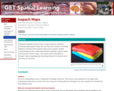
Play-Doh model of a sedimentary wedge (yellow), tapering out between two other …
Play-Doh model of a sedimentary wedge (yellow), tapering out between two other strata
Provenance: Carol Ormand Ph.D., Carleton College Reuse: This item is offered under a Creative Commons Attribution-NonCommercial-ShareAlike license http://creativecommons.org/licenses/by-nc-sa/3.0/ You may reuse this item for non-commercial purposes as long as you provide attribution and offer any derivative works under a similar license. Students complete several short, in-class exercises related to understanding isopach maps. We use Play-Doh models to illustrate features revealed in the isopach maps and to support student understanding of the relationship between geology, isopach maps, and structure contour maps. I also show several examples of isopach maps of geologically interesting features to illustrate how and why we use them.
(Note: this resource was added to OER Commons as part of a batch upload of over 2,200 records. If you notice an issue with the quality of the metadata, please let us know by using the 'report' button and we will flag it for consideration.)
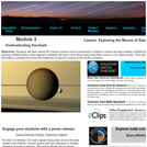
This is a set of three, one-page problems about the sizes of …
This is a set of three, one-page problems about the sizes of moons in the solar system. Learners will use decimals to compare the sizes and distances of Saturn's moons to the center of Saturn. Options are presented so that students may learn about the Cassini mission through a NASA press release or by viewing a NASA eClips video [4 min.] about these and other moons in our solar system. This activity is part of the Space Math multi-media modules that integrate NASA press releases, NASA archival video, and mathematics problems targeted at specific math standards commonly encountered in middle school.
SSAC Geology of National Parks module/Geology of National Parks course. Students calculate …
SSAC Geology of National Parks module/Geology of National Parks course. Students calculate probabilities using USGS hydrograph data, a spreadsheet of daily stage heights, and the COUNTIF function.
In the late 1970s, scientists conducting a geologic investigation of the ocean …
In the late 1970s, scientists conducting a geologic investigation of the ocean floor in the Pacific made a startling discovery - deep ocean hot springs populated by a host of organisms never before seen. Join Dr. Horst Felbeck as he describes his fascinating research into what makes life possible in this seemingly inhospitable environment. (43 minutes)
This activity allows students to better understand radiometric dating and absolute dating …
This activity allows students to better understand radiometric dating and absolute dating techniques by calculating radiometric ages of zircon crystals. Their calculated ages then serve as tools to practice creating graphs, interpret analytic data, and reconstruct geologic events.
(Note: this resource was added to OER Commons as part of a batch upload of over 2,200 records. If you notice an issue with the quality of the metadata, please let us know by using the 'report' button and we will flag it for consideration.)
The use of dendrochronology in determining the geologic history of a location. …
The use of dendrochronology in determining the geologic history of a location. The development of an understanding how tree growth can indicate the relationships between climate, geomorphology, ecology and archeology.
(Note: this resource was added to OER Commons as part of a batch upload of over 2,200 records. If you notice an issue with the quality of the metadata, please let us know by using the 'report' button and we will flag it for consideration.)
Average inquiry level: Guided inquiry In this laboratory exercise for introductory geology …
Average inquiry level: Guided inquiry In this laboratory exercise for introductory geology or environmental science courses, students use data to examine climate change in their local environment. They compare local changes to global data over different time scales. As an assessment, students create an infographic to demonstrate their understanding of how local climate change may affect their region and what people can do to be better prepared. This lab was originally designed for online instruction, but may be used in face-to-face instruction as well.
(Note: this resource was added to OER Commons as part of a batch upload of over 2,200 records. If you notice an issue with the quality of the metadata, please let us know by using the 'report' button and we will flag it for consideration.)
In the hierarchical alignment activity, students are given multiple opportunities to align …
In the hierarchical alignment activity, students are given multiple opportunities to align time to space in a linear representation. They begin by scaling a familiar amount of time (e.g. a personal time line) to a spatial representation (e.g. a meter stick), and progressively align increasing/decreasing amounts until completing the target unfamiliar time line (e.g. geologic time). For example, in the hierarchical alignment of geologic time, students can work through 10 time lines: personal, human lifespan, American history, Recorded history, human evolution, Cenozoic, Phanerozoic, Proterozoic, Archean, and then Hadean.
While the amount of time varies, the amount of space remains constant: in this example, students align all new temporal scales to one meter. For each time line, students are asked to locate specific events, hierarchicaly organized divisions of time, and the length of the time line in order to engage the students in thinking about that temporal scale. Additionally, every time students align a new temporal scale to space, they locate all previous scales relative to the current scale.
(Note: this resource was added to OER Commons as part of a batch upload of over 2,200 records. If you notice an issue with the quality of the metadata, please let us know by using the 'report' button and we will flag it for consideration.)
This is a kick-off activity about the solar system and Jupiter. Learners …
This is a kick-off activity about the solar system and Jupiter. Learners will discuss what they know, work in teams to read about the Sun, eight planets, asteroid belt, and the dwarf planet, Pluto. They use their knowledge to create a poster about each object, which can be displayed in the library and used in later activities. This activity is part of Explore! Jupiter's Family Secrets, a series designed to engage children in space and planetary science in libraries and informal learning environments.
The Museum's Gottesman Hall of Planet Earth allows visitors to explore geologic …
The Museum's Gottesman Hall of Planet Earth allows visitors to explore geologic time and to gain an understanding of the methods scientists use to study vast Earth systems. This comprehensive guide to the hall's resources is designed to help you maximize your trip to the Museum with elementary school students. It includes detailed background information, a map of the hall that shows the five sections of the exhibit and several pre-, during-, and post-visit activities to do with your students. There is a listing of related Museum exhibits and suggestions for how to tie them into your field trip and notes about how the topics featured in the hall address performance standards and curriculum requirements.
In this in-class activity, students are challenged to identify rock units and …
In this in-class activity, students are challenged to identify rock units and geologic features and determine the relative ages of these features without prior instruction in the classical methods of relative age determination.
(Note: this resource was added to OER Commons as part of a batch upload of over 2,200 records. If you notice an issue with the quality of the metadata, please let us know by using the 'report' button and we will flag it for consideration.)
This project is based on either a class field trip, or an …
This project is based on either a class field trip, or an assigned topic in structural geology. In either case, the students are responsible for representing their experiences in the form of a comic or graphic novel. The experience is therefore largely visual, but it gives students an opportunity to translate their thoughts into a non-traditional medium.
(Note: this resource was added to OER Commons as part of a batch upload of over 2,200 records. If you notice an issue with the quality of the metadata, please let us know by using the 'report' button and we will flag it for consideration.)
This is an activity about ellipses, their focal points, and how the …
This is an activity about ellipses, their focal points, and how the mathematics involved pertains to planetary orbits. Learners will draw their own ellipse using a string and pencil and calculate the minimum and maximum distance from the Sun for each of the planets. This activity requires access to the Space Weather software and is Solar System Activity 5 in a larger resource, titled Space Update.
This assignment is meant to illustrate how the advection of heat by …
This assignment is meant to illustrate how the advection of heat by groundwater leads to the elevated temperatures at shallow sedimentary basin margins at which Mississippi Valley-type Zn-Pb hydrothermal ore deposits are formed. The assignment is based on analytical solutions for groundwater flow and heat transport published by Domenico & Palciauskas (1973). Students use a spreadsheet to calculate and plot the flow field and temperature in a sedimentary basin, and to investigate the conditions needed to produce ore-forming temperatures. These results have further implications for the length of time available for ore formation and the concentration of metals and pH of the groundwater, which are also explored in the assignment. The assignment provides an example of how groundwater plays a fundamental role in an important geologic process in the Earth's crust. The activity also shows the linkages of hydrology to other disciplines such as heat transport, geochemistry, and economic geology.
(Note: this resource was added to OER Commons as part of a batch upload of over 2,200 records. If you notice an issue with the quality of the metadata, please let us know by using the 'report' button and we will flag it for consideration.)
When piecing together the geologic history of the Earth, geologists rely on …
When piecing together the geologic history of the Earth, geologists rely on several key relative age-dating principles that allow us to determine the relative ages of rocks and the timing of significant geologic events. In a typical Historical Geology class or textbook, instructors/authors briefly discuss the important early researchers in the geological sciences, and then give the name of the stratigraphic principle, useful for relative age-dating of rocks and events, that these 17th and 18th century scientists are credited with discovering. After the instructor/author defines these principles, students are usually shown several examples so they can see how the principle can be applied.
But why not start with the examples and let students discover these principles for themselves?
Students are split into small groups which each work to discover a different relative age-dating principle. The groups are shown photos and given handouts with drawings of rock outcrops illustrating the various principles. These handouts include worksheets for which they must answer a series of prompts that help lead them to the discovery of their relative age-dating principle. Groups must also invent a name for their principle, and select a spokesperson who will present the group's results to the rest of the class.
(Note: this resource was added to OER Commons as part of a batch upload of over 2,200 records. If you notice an issue with the quality of the metadata, please let us know by using the 'report' button and we will flag it for consideration.)
This lab focuses on the identification of impact features, and how they …
This lab focuses on the identification of impact features, and how they can used to estimate the age of planetary surfaces. Key comcepts include understanding how the crater process has changed over geologic time; how those changes manifest themselves in the surficial record of planetary landforms; how other planetary processes modify surficial landforms; how the conditions of the Solar System have changed over time.
(Note: this resource was added to OER Commons as part of a batch upload of over 2,200 records. If you notice an issue with the quality of the metadata, please let us know by using the 'report' button and we will flag it for consideration.)
In this video segment adapted from NOVA, scientists are startled to discover …
In this video segment adapted from NOVA, scientists are startled to discover evidence for the three key ingredients for life on Saturn's moon Enceladus.
DATA: Recent and Historical Earthquake Data. TOOL: ArcExplorer Java Edition for Education …
DATA: Recent and Historical Earthquake Data. TOOL: ArcExplorer Java Edition for Education GIS. SUMMARY: Explore earthquake data and import them into a Geographic Information System (GIS). Analyze the data to predict where the next big earthquake will occur.
(Note: this resource was added to OER Commons as part of a batch upload of over 2,200 records. If you notice an issue with the quality of the metadata, please let us know by using the 'report' button and we will flag it for consideration.)
No restrictions on your remixing, redistributing, or making derivative works. Give credit to the author, as required.
Your remixing, redistributing, or making derivatives works comes with some restrictions, including how it is shared.
Your redistributing comes with some restrictions. Do not remix or make derivative works.
Most restrictive license type. Prohibits most uses, sharing, and any changes.
Copyrighted materials, available under Fair Use and the TEACH Act for US-based educators, or other custom arrangements. Go to the resource provider to see their individual restrictions.