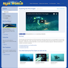
Once the pride of the German Navy, this 700 foot long heavy …
Once the pride of the German Navy, this 700 foot long heavy cruiser was used by the U.S. as a test target for not one but two atom bombs at Bikini atoll. Today, at the bottom of the ocean, the radiation levels of the Prinz Eugen are low enough for safe exploration. In this video, Jonathan joins historian Mark Miller on a trip to explore this mysterious shipwreck. What they find about the condition of this wreck is surprising. Please see the accompanying lesson plan for educational objectives, discussion points and classroom activities.
This class examines tools, data, and ideas related to past climate changes …
This class examines tools, data, and ideas related to past climate changes as seen in marine, ice core, and continental records. The most recent climate changes (mainly the past 500,000 years, ranging up to about 2 million years ago) will be emphasized. Quantitative tools for the examination of paleoceanographic data will be introduced (statistics, factor analysis, time series analysis, simple climatology).
This subject teaches students, having an initial interest in sailing design, how …
This subject teaches students, having an initial interest in sailing design, how to design good yachts. Topics covered include hydrostatics, transverse stability, and the incorporation of the design spiral into one’s working methods. Computer aided design (CAD) is used to design the shapes of hulls, appendages and decks, and is an important part of this course. The capstone project in this course is the Final Design Project in which each student designs a sailing yacht, complete in all major respects. The central material for this subject is the content of the book Principals of Yacht Design by Larssson and Eliasson (see further description in the syllabus). All the class lectures are based on the material in this book. The figures in the book which are shown in class (but not reproduced on this site), contain the essential material and their meaning is explained in detail during the lecture sessions. Mastery of the material in the book and completing a design project provides the desired and needed education. This course was originally offered in Course 13 (Department of Ocean Engineering) as 13.734. In 2005, ocean engineering subjects became part of Course 2 (Department of Mechanical Engineering), and this course was renumbered 2.996.
This is a field and computer laboratory exercise that introduces undergraduate students, …
This is a field and computer laboratory exercise that introduces undergraduate students, advanced high school students, and members of the general public to using Google Earth, GPS, aerial imagery, and an online illustrated vegetation and tidal marsh environment identification guide to distinguish and map vegetational and physical environmental zones within a salt marsh. They also learn about the physical and ecological relationships between these environments.
Students use GPS devices to collect field data as waypoints and tracks, and upload the data to computers in GPX format. They learn to open the data in Google Earth along with infrared and color aerial imagery, and use the GPS data to interpret the aerial imagery. Using Google Earth tools, they draw polygons to demarcate the boundaries of environmental zones in the wetlands that they recognize on the imagery.
The students and instructors also take photographs of the students in each of these environmental zones and embed the photographs into information balloons of placemarks in Google Earth.
The exercise was originally designed for use at Flax Pond, a salt marsh on the North Shore of Long Island. However, it can easily be adapted for use in other tidal marshes, and can serve as a template for developing similar activities to be conducted at other locations in which aerial imagery can be used to distinguish various forms of land cover.
(Note: this resource was added to OER Commons as part of a batch upload of over 2,200 records. If you notice an issue with the quality of the metadata, please let us know by using the 'report' button and we will flag it for consideration.)
In this activity, students use real water chemistry data and descriptive statistics …
In this activity, students use real water chemistry data and descriptive statistics in Excel to examine primary productivity in an urban estuary of the Salish Sea. They will consider how actual data do or do not support expected annual trends.
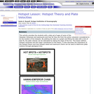
This activity provides the students with a data set of ages of …
This activity provides the students with a data set of ages of some of the Hawaiian Volcanoes and seamounts and how far they are from the active volcanism (considered to be the location of the hotspot). By plotting the data on a graph and fitting the data with a line of best fit, the plate velocity can be estimated by taking the slope of the line.
(Note: this resource was added to OER Commons as part of a batch upload of over 2,200 records. If you notice an issue with the quality of the metadata, please let us know by using the 'report' button and we will flag it for consideration.)
Jamie A. Russell, Scripps Institution of Oceanography
Related Links
Relative Dating
Mantle Plumes
Samoan Hotspot
Final Hotspot Project
View Lesson Plan at ERESE ...
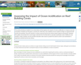
This activity introduces students to an actual data set that explores the …
This activity introduces students to an actual data set that explores the impacts of ocean acidification on tropical coral reef ecosystems. Students are first given a scenario for a field site in the Caribbean and are asked to design an experiment that answers the question: How will a decline in surface ocean pH by the 21st century impact tropical coral growth? Students then gather actual data (from coral images collected from the field site) to calculate calcification rates of different coral samples. Finally, students use the provided saturation state values to predict the extent to which coral calcification is expected to decline by the 21st century.
The purpose of this 3 ACT task is to provide students with …
The purpose of this 3 ACT task is to provide students with an opportunity to problem solve based on a real-world situation. In the task, students are presented with a map of a Bull Kelp bed near Squaxin Island and asked to generate their own questions that could be answered using the map. Students then decide on necessary resources for finding the solution and are given time as a group to complete their work. The task concludes by having students examine the information provided in Act three to see if it answers their question. Includes slides to support the implementation of "Keeping An Eye On Kelp (Algebra)" Math Performance Task with charts, images, etc.
Most students understand that water quality is an important issue, however many …
Most students understand that water quality is an important issue, however many do not understand the complexity associated with the processes involved, the complex nature of estuarine systems, or the fact that management decisions are made based on available data sets that can be difficult at best to interpret. Students will be provided nutrient data in Excel for two Texas estuaries which they will supplement with additional information that they have compiled on these two estuaries during the duration of the course through a GIS database available to the entire class. Furthermore, students will retrieve information from the WWW to learn more about the specific estuaries and the nutrients of interest and their impacts on the environment.
(Note: this resource was added to OER Commons as part of a batch upload of over 2,200 records. If you notice an issue with the quality of the metadata, please let us know by using the 'report' button and we will flag it for consideration.)
Introduction to dynamics and vibration of lumped-parameter models of mechanical systems. Three-dimensional …
Introduction to dynamics and vibration of lumped-parameter models of mechanical systems. Three-dimensional particle kinematics. Force-momentum formulation for systems of particles and for rigid bodies (direct method). Newton-Euler equations. Work-energy (variational) formulation for systems particles and for rigid bodies (indirect method). Virtual displacements and work. Lagrange’s equations for systems of particles and for rigid bodies. Linearization of equations of motion. Linear stability analysis of mechanical systems. Free and forced vibration of linear damped lumped parameter multi-degree of freedom models of mechanical systems. Application to the design of ocean and civil engineering structures such as tension leg platforms. This subject was originally offered in Course 13 (Department of Ocean Engineering) as 13.013J. In 2005, ocean engineering became part of Course 2 (Department of Mechanical Engineering), and this subject merged with 2.003.
This course begins with the foundations of 3D elasticity, fluid and elastic …
This course begins with the foundations of 3D elasticity, fluid and elastic wave equations, elastic and plastic waves in rods and beams, waves in plates, and dynamics and acoustics of cylindrical shells. The course considers acoustic fluids effects such as radiation and scattering by submerged plates and shells, and interaction between structural elements. Finally, it covers the response of plates and shells to high-intensity loads, dynamic plasticity and fracture, and structural damage caused by implosive and impact loads. This course was originally offered in Course 13 (Department of Ocean Engineering) as 13.811. In 2005, ocean engineering subjects became part of Course 2 (Department of Mechanical Engineering), and this course was renumbered 2.067.
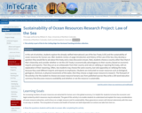
Students consider the history and development of the United Nations Law of …
Students consider the history and development of the United Nations Law of the Sea Treaty, with a focus on extraction of natural resources from the ocean. Sustainability of a single resource is investigated in detail.
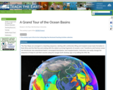
The Tour Stops are arranged in a teaching sequence, starting with continental …
The Tour Stops are arranged in a teaching sequence, starting with continental rifting and incipient ocean basin formation in East Africa and the Red Sea and ending with the oldest surviving fragments of oceanic crust. Transforms and fracture zones are introduced, also abandoned basins, convergent boundaries, and marginal basins. Instructors can easily change the sequence of stops to suit their courses using the Google Earth desktop app or by editing the KML file.
The ORSEA program connects math and science educators with scientists to create …
The ORSEA program connects math and science educators with scientists to create and pilot lessons centered around marine-focused anchoring phenomena. ORSEA supports data science education and ocean literacy, while also exposing students to a variety of marine-related careers. This project is funded by Oregon Sea Grant and the National Science Foundation through OSU's Regional Class Research Vessel Project.
Currently there are 23 lessons/units integrate math and marine science in units and lessons for students in grades 6 - 12.
Human-induced nutrient loading of the world's oceans has been linked to increased …
Human-induced nutrient loading of the world's oceans has been linked to increased and prolonged algae blooms, sometimes with potentially deadly consequences. In this investigation, students will create their own algal blooms, analyze satellite images of chlorophyll concentrations in the Sea of CortÃs, and learn about two alarming consequences of excessive algae growth-—dead zones and harmful algae blooms (HABs).
(Note: this resource was added to OER Commons as part of a batch upload of over 2,200 records. If you notice an issue with the quality of the metadata, please let us know by using the 'report' button and we will flag it for consideration.)
2.26 is a 6-unit Honors-level subject serving as the Mechanical Engineering department’s …
2.26 is a 6-unit Honors-level subject serving as the Mechanical Engineering department’s sole course in compressible fluid dynamics. The prerequisites for this course are undergraduate courses in thermodynamics, fluid dynamics, and heat transfer. The goal of this course is to lay out the fundamental concepts and results for the compressible flow of gases. Topics to be covered include: appropriate conservation laws; propagation of disturbances; isentropic flows; normal shock wave relations, oblique shock waves, weak and strong shocks, and shock wave structure; compressible flows in ducts with area changes, friction, or heat addition; heat transfer to high speed flows; unsteady compressible flows, Riemann invariants, and piston and shock tube problems; steady 2D supersonic flow, Prandtl-Meyer function; and self-similar compressible flows. The emphasis will be on physical understanding of the phenomena and basic analytical techniques.
This course is about maneuvering motions of surface and underwater vehicles. Topics …
This course is about maneuvering motions of surface and underwater vehicles. Topics covered include: derivation of equations of motion, hydrodynamic coefficients, memory effects, linear and nonlinear forms of the equations of motion, control surfaces modeling and design, engine, propulsor, and transmission systems modeling and simulation during maneuvering. The course also deals with stability of motion, principles of multivariable automatic control, optimal control, Kalman filtering, and loop transfer recovery. We will also explore applications chosen from autopilots for surface vehicles; towing in open seas; and remotely operated vehicles. This course was originally offered in Course 13 (Department of Ocean Engineering) as 13.49. In 2005, ocean engineering subjects became part of Course 2 (Department of Mechanical Engineering), and this course was renumbered 2.154.
This course is an introduction to numerical methods: interpolation, differentiation, integration, and …
This course is an introduction to numerical methods: interpolation, differentiation, integration, and systems of linear equations. It covers the solution of differential equations by numerical integration, as well as partial differential equations of inviscid hydrodynamics: finite difference methods, boundary integral equation panel methods. Also addressed are introductory numerical lifting surface computations, fast Fourier transforms, the numerical representation of deterministic and random sea waves, as well as integral boundary layer equations and numerical solutions. This course was originally offered in Course 13 (Department of Ocean Engineering) as 13.024. In 2005, ocean engineering subjects became part of Course 2 (Department of Mechanical Engineering), and this course was renumbered 2.29.
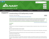
To prepare for this lab, students read a section of the textbook …
To prepare for this lab, students read a section of the textbook about observational techniques to measure the seafloor bathymetry as well as the occurrence of common sea floor features, such as seamounts, coastal shelves, mid-ocean ridges, and trenches. In the first lab, groups of students are provided with a bathymetric map, cutting board, sharp edges, and plenty of cardboard. They trace some contours from the map onto tracing paper, and then cut those out of the cardboard to construct a scale model of their given sea floor feature. They attach the sheets of cardboard with double-sided tape, and affix it to the bottom of a rigid box. The box lid has a grid of holes drilled into it. They determine the scale of the map (cm of the model to km in the ocean, for example), and affix the scale to the outside of the box. This concludes the first lab session.
In the second lab session, each team of students is provided with a box from an unknown team. The box is closed, and they do not know what ocean feature lay inside. They use bamboo skewers to take "soundings" at each of the drilled holes in the box lid, and mark their measurements on a piece of graph paper. Then they construct a contour map from the soundings, and try to identify the sea floor feature in the box from a global seafloor topography map that is hanging on a wall.
Students complete guided questions about the process of constructing their 3D scaled model and exploring the unknown ocean.
This course is an introduction to numerical methods and MATLAB®: Errors, condition …
This course is an introduction to numerical methods and MATLAB®: Errors, condition numbers and roots of equations. Topics covered include Navier-Stokes; direct and iterative methods for linear systems; finite differences for elliptic, parabolic and hyperbolic equations; Fourier decomposition, error analysis and stability; high-order and compact finite-differences; finite volume methods; time marching methods; Navier-Stokes solvers; grid generation; finite volumes on complex geometries; finite element methods; spectral methods; boundary element and panel methods; turbulent flows; boundary layers; and Lagrangian coherent structures (LCSs). Prof. Pierre Lermusiaux is very grateful to the teaching assistants Dr. Matt Ueckermann, Dr. Tapovan Lolla, Mr. Jing Lin, and Mr. Arpit Agarwal for their contributions to the course over the years.
No restrictions on your remixing, redistributing, or making derivative works. Give credit to the author, as required.
Your remixing, redistributing, or making derivatives works comes with some restrictions, including how it is shared.
Your redistributing comes with some restrictions. Do not remix or make derivative works.
Most restrictive license type. Prohibits most uses, sharing, and any changes.
Copyrighted materials, available under Fair Use and the TEACH Act for US-based educators, or other custom arrangements. Go to the resource provider to see their individual restrictions.