This is a research project for an Environmental Geology class, in which …
This is a research project for an Environmental Geology class, in which each student selects or is assigned a type of alternative energy to investigate. The project culminates in a 10-15 minute class presentation with accompanying written abstract.
In this year’s Geodynamics Seminar, we will explore the depth and breadth …
In this year’s Geodynamics Seminar, we will explore the depth and breadth of scientific research related to Earth’s present and past ice-sheets, glaciers and sea-ice, as well as extraterrestrial planetary ice. Invited speakers have been chosen from experts in the current frontiers in ice-related research, including planetary ice, climate records from polar and tropical ice cores, the Snowball Earth, subglacial volcanoes, ice rheology, ice sheet modeling, ice microkinetics, glacial erosion and tectonics, subglacial life and polar remote sensing. A field trip to Iceland in Summer 2006 will allow us to view some of the island’s ice caps and glacial geology, the exposed mid Atlantic Ridge and evidence of ice-volcano interactions.
This activitiy is a lab experience where students observe, compare and classify …
This activitiy is a lab experience where students observe, compare and classify rocks. Close examination of a variety of rocks reveals their differences and can also spark questions regarding their origins.
This quiz for younger students asks them 10 questions about plate motions, …
This quiz for younger students asks them 10 questions about plate motions, rock types in continental and oceanic crust, crustal formation and mountain building, the supercontinent Pangea, and the theory of continental drift. A link to a page on continental drift provides information to answer the questions.
Lo que vemos en la superficie de la Tierra es un conjunto …
Lo que vemos en la superficie de la Tierra es un conjunto complejo y dinámico de sistemas interconectados que incluyen la geósfera, la hidrósfera, la atmósfera, la criósfera y la biósfera. Los procesos de la Tierra son el resultado del flujo de energía y el ciclo de la materia que está dentro y entre estos sistemas. Comprender los sistemas de la Tierra es importante para muchas decisiones que se toman hoy en las comunidades, por ejemplo en dónde construir una carretera, en dónde un salmón puede poner huevos con éxito y cómo garantizar la calidad del aire. La erosión involucra las cinco esferas, lo que brinda a los estudiantes un excelente ejemplo de la interconexión de estos grandes sistemas.
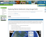
This exercise uses empirical data and Google Earth to explore the surficial …
This exercise uses empirical data and Google Earth to explore the surficial distribution of marine sediments in the modern ocean. Over 2500 sites are plotted with access to original data. We recommend first completing the Primer on Google Earth to become familiar with tools in Google Earth that are used in this exercise. The Exploring Marine Sediments in Google Earth exercise has four parts:
- Stories from the Sea Floor: A Lesson on How Science Works - A First Look at Marine Sediments - Exploring the Distribution of Marine Sediment Types on the Sea Floor - Refining Your Hypotheses on Biogenic Marine Sediment Distributions
A 15-20 minute think-pair-share activity interpreting a deep-sea sediment core combining concepts …
A 15-20 minute think-pair-share activity interpreting a deep-sea sediment core combining concepts from oceanography, sedimentology, and plate tectonics.
(Note: this resource was added to OER Commons as part of a batch upload of over 2,200 records. If you notice an issue with the quality of the metadata, please let us know by using the 'report' button and we will flag it for consideration.)
An ability to read and use simple igneous phase diagrams is a …
An ability to read and use simple igneous phase diagrams is a major goal of most undergraduate courses in petrology. Many students have difficulty attaining this goal because phase diagrams are an unfamiliar kind of graph and they are described in most textbooks with an unfamiliar language
This activity is intended to fill the first part of a class …
This activity is intended to fill the first part of a class period on mining and mining impacts. It is a hands-on activity in which students, in small groups, "mine" the blueberries or chocolate chips out of a muffin. This activity helps to review the reading materials and facilitate discussion about mining and mining methods, waste, beneficiation, landscape destruction, reclamation methods, and more.
(Note: this resource was added to OER Commons as part of a batch upload of over 2,200 records. If you notice an issue with the quality of the metadata, please let us know by using the 'report' button and we will flag it for consideration.)
This Web site, created to complement the Museum's Gottesman Hall of Planet …
This Web site, created to complement the Museum's Gottesman Hall of Planet Earth, offers a virtual visit to the Museum, complete with text, photos, and a downloadable desktop background. The site contains information on ten exhibition highlights.
This activity is a guided inquiry where students develop questions around a …
This activity is a guided inquiry where students develop questions around a group of rocks, use their observation skills to describe the attributes, record and analyze their findings, and use their data, in conjunction with available resources, to categorize the rocks .
Students collect a soil near their house or other location, analyze it …
Students collect a soil near their house or other location, analyze it using grain size, plot the locations and collectively create a soils map of campus or larger area. This exercise can be tailored for many different grade levels. I've used it from 4th grade through Physical Geology classes
This activity is a lab presentation where students gather data about rocks …
This activity is a lab presentation where students gather data about rocks from their area and hypothesize what the rocks are and where they came from.
This unit offers an alternative application for high-resolution topographic data from an …
This unit offers an alternative application for high-resolution topographic data from an outcrop. Using engineering geology methods and data collection from TLS and/or SfM, students design safe "road cuts" with low probability of failure for a proposed fictitious roadway along the side of a hill. Cut slopes or "road cuts" are constructed slopes along roadways in mountainous regions. The design of such slopes requires a safe slope angle, rockfall catchment ditch, and drainage provision. The decision of the slope angle is based on kinematic analysis for slope failures due to the orientation of discontinuities (bedding planes, joints, etc.) with respect to that of the proposed slope. Traditionally, discontinuity orientation data are collected from measurements directly on the outcrop. This can be dangerous and the accessible sites may not be fully representative of the cut as a whole. Remote methods such as TLS and SfM generate 3D models from which discontinuity data can be collected safely. In this unit students learn the workflow for designing safe cut slopes using discontinuity data collected from direct field observations and TLS or SfM and compare the methods and results.
(Note: this resource was added to OER Commons as part of a batch upload of over 2,200 records. If you notice an issue with the quality of the metadata, please let us know by using the 'report' button and we will flag it for consideration.)
This undergraduate petrology course surveys the distribution, chemical composition, and mineral associations …
This undergraduate petrology course surveys the distribution, chemical composition, and mineral associations in rocks of the earth’s crust and upper mantle, and establishes its relation to tectonic environment. The emphasis of the course is on the use of chemistry and physics to interpret rock forming processes.
No restrictions on your remixing, redistributing, or making derivative works. Give credit to the author, as required.
Your remixing, redistributing, or making derivatives works comes with some restrictions, including how it is shared.
Your redistributing comes with some restrictions. Do not remix or make derivative works.
Most restrictive license type. Prohibits most uses, sharing, and any changes.
Copyrighted materials, available under Fair Use and the TEACH Act for US-based educators, or other custom arrangements. Go to the resource provider to see their individual restrictions.