This is a static visualization, referenced from a UNEP rapid response assessment …
This is a static visualization, referenced from a UNEP rapid response assessment report entitled In Dead Water, depicting the estimated contributions to sea-level rise from 1993 - 2003.
The learning objectives for this GIS exercise are to 1) understand rainfall …
The learning objectives for this GIS exercise are to 1) understand rainfall spatial variability and how to account for it when making areal-rainfall estimates, and 2) learn how ArcGIS can be used as a tool to determine areal averages, and 3) compare the advantages and drawbacks of the various techniques.
(Note: this resource was added to OER Commons as part of a batch upload of over 2,200 records. If you notice an issue with the quality of the metadata, please let us know by using the 'report' button and we will flag it for consideration.)
On July 4th, 1997, Mars Pathfinder landed at the mouth of Ares …
On July 4th, 1997, Mars Pathfinder landed at the mouth of Ares Vallis, a large channel that drains into the Chryse Planitia basin. While there remains a great deal to debate about the origin of the channels, one of the leading hypotheses at present is the idea that these features are the result of catastrophic flooding. If this is correct, then the plains where Pathfinder landed may be rich in debris eroded out of the Martian highlands across which the Ares Vallis channel passes, providing a golden combination -- a relatively safe landing site which still provides access to a wide variety of different rock types. [If you would like to learn more about the many Pathfinder results, explore the April, 1999 and January, 2000 issues of the journal Journal of Geophysical Research -- Planets (the green one) in the library.]
For the sake of this lab assignment you will hypothesize that the Ares Vallis and associated deposits were indeed produced by catastrophic flooding, and will use the information at your disposal to learn all you can about the putative flooding event.
(Note: this resource was added to OER Commons as part of a batch upload of over 2,200 records. If you notice an issue with the quality of the metadata, please let us know by using the 'report' button and we will flag it for consideration.)
Simple budgets may be used to estimate the exchange of water in …
Simple budgets may be used to estimate the exchange of water in embayments that capitalize on the concept of steady state and conservation principals. This is especially true for bays that experience a significant exchange of freshwater. This exchange of freshwater may reduce the average salt concentration in the bay compared to seawater if it involves addition of freshwater from rivers, R, and/or precipitation, P. Alternatively, it may increase the average salt concentration in the bay compared to seawater if there is relatively little river input and high evaporation, E. Since freshwater input changes the salt concentration in the bay, and salt is a conservative material, it is possible to combine two steady state budgets for a bay, one for salt and one for water, to solve for the magnitude of the water flows that enter and exit the bay mouth. Students will make actual calculations for the inflow and outflow of water to Puget Sound, Washington and the Mediterranean Sea and compare them to actual measured values.
(Note: this resource was added to OER Commons as part of a batch upload of over 2,200 records. If you notice an issue with the quality of the metadata, please let us know by using the 'report' button and we will flag it for consideration.)
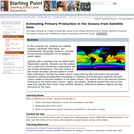
In this computer lab, students use satellite imagery, daylength information, and phytoplankton …
In this computer lab, students use satellite imagery, daylength information, and phytoplankton physiology models to calculate annual primary production for an assigned ocean region.
Satellite data is obtained from the NASA Earth Observation website. Students use the analysis tool to determine chlorophyll concentration and sea surface temperature. They also receive a day-length calculator and are asked to model light transmission through the water column. Using step-by-step instructions and proviede equations relating phytoplankton physiology to irradiance and temperature students calculate carbon uptake at discreet locations in the water column. The second half of the exercise involves scaling up to the entire water column, region, and season. Students present their work to the class and evaluate their result using scientific literature. Differences between regions are then discussed by the class.
(Note: this resource was added to OER Commons as part of a batch upload of over 2,200 records. If you notice an issue with the quality of the metadata, please let us know by using the 'report' button and we will flag it for consideration.)
Using a website, students virtually sample water from a stream at different …
Using a website, students virtually sample water from a stream at different levels of pollution, and observe the differences in macroinvertebrate species present. The collected data is analyzed by calculating the percentage of each species present and answering questions based on their findings.
Students make measurements of dam dimensions and water levels above and below …
Students make measurements of dam dimensions and water levels above and below a small, accessible earthen dam. They assess the soil texture in the field. They follow up by developing a simple flow net and estimating seepage rate as part of a problem set. They discuss their assumptions and the likely sources and magnitude of error.
(Note: this resource was added to OER Commons as part of a batch upload of over 2,200 records. If you notice an issue with the quality of the metadata, please let us know by using the 'report' button and we will flag it for consideration.)
Students explore material properties in hands-on and visually evident ways via the …
Students explore material properties in hands-on and visually evident ways via the Archimedes' principle. First, they design and conduct an experiment to calculate densities of various materials and present their findings to the class. Using this information, they identify an unknown material based on its density. Then, groups explore buoyant forces. They measure displacement needed for various materials to float on water and construct the equation for buoyancy. Using this equation, they calculate the numerical solution for a boat hull using given design parameters.
Evaluating has been called one of the six most important reading comprehension …
Evaluating has been called one of the six most important reading comprehension strategies. In this article, it is also considered as a strategy for analyzing and interpreting data. This professional development article appears in the free, online magazine Beyond Weather and the Water Cycle, which integrates science education and literacy instruction for K-grade 5 teachers. Each issue examines one of the recognized essential principles of climate literacy and the climate sciences and one or more reading strategies for elementary teachers and their students.
Students will be given the task to build a dam that will …
Students will be given the task to build a dam that will stand against water. Students will design and build a scaled model of a dam and test the model for the ability to reduce the impact of a flood. Students will build a scaled model dam and test the dam's effectiveness in preventing flood waters. Students will evaluate the efficacy of the dam they constructed and built. Students will contemplate what actions can be taken and materials that could be used in order to create a more effective dam in the future. This unit was created as part of the ALEX Interdisciplinary Resource Development Summit.
This is a semester-long jigsaw project in which students work in teams …
This is a semester-long jigsaw project in which students work in teams to explore the effects of energy resource development on local water resources, economics, and society. Students are presented with a contemporary energy resource development issue being debated in their community. They research the water, geological, economic, and social impact of the project, and then either defend or support the development proposal.
This module introduces students to the fundamental principles and uses of electrical …
This module introduces students to the fundamental principles and uses of electrical resistivity, with a focus on an environmental application. Students explore the characteristics and environmental setting of Harrier Meadow, a saltmarsh just outside of New York City. They investigate the relationship between electrical resistivity and physical properties of the soil in the marsh. Students also discover how variations in survey configuration parameters control investigation depth (how far into the ground the signals sense) and spatial resolution (what size objects can be detected). Finally, students learn about and then perform geophysical inversion, which is the process of estimating the geophysical properties of the subsurface from geophysical observations. In the final unit of the module, students evaluate the extent to which the geophysical dataset and direct physical measurements support the hypothesis, introduced in Unit 1, accounting for the distribution of Pickleweed in Harrier Meadow. This module is intended to require approximately 2-3 weeks of class time. Teaching material includes PowerPoints that may be used in lectures or provided for self-guided learning, exercises, and handouts that ask students to synthesize what they learn from the exercises. In addition, multiple choice and short answer questions can be given to students as homework, on quizzes, or on exams.
(Note: this resource was added to OER Commons as part of a batch upload of over 2,200 records. If you notice an issue with the quality of the metadata, please let us know by using the 'report' button and we will flag it for consideration.)
This assignment is best presented in two lab periods to represent the …
This assignment is best presented in two lab periods to represent the "before" and "after" scenarios of land use and their impact on hydrology. It requires documentation in map and/or airphoto form of land use in a specific watershed at two times: historical and modern. Historical USGS topographic maps from the 19th century were used in this case, along with digital orthophotos for the modern-day scenario. Some means of quantifying subareas within the watershed is also needed, either using software (ArcGIS) or transparent overlays and boxcounting from a translucent grid would work. For each of the sets of documentation: historical and modern, the students follow the USDA-NRCS TR55 empirical procedure to estimate event runoff depths and peak estimated discharge from the watershed. An area-weighted curve number (CN) is calculated based on tabulated categories of land use. Some judgment is involved in adapting the tabulated land use categories to the specific watershed used, and selecting an appropriate statistical average rainfall event to use. The sum of Darcy's Law calculations of discharge along streamtubes to a surface stream or estuary provides a groundwater discharge value over time for comparison. Each of these parts of the activity provides opportunities for the instructor to discuss uncertainties and sources of error. Note that although software allowing TR-55 analysis exists, it is simpler and more instructive to have students use the paper method and forms in the manual.
(Note: this resource was added to OER Commons as part of a batch upload of over 2,200 records. If you notice an issue with the quality of the metadata, please let us know by using the 'report' button and we will flag it for consideration.)
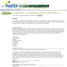
Students observe the process of evaporation, make comparisons about the process, then …
Students observe the process of evaporation, make comparisons about the process, then construct a diagram and use it to describe the process of evaporation.
This is a hands-on lab activity about evaporation. Learners will conduct experiments …
This is a hands-on lab activity about evaporation. Learners will conduct experiments to observe the process of evaporation. They will then describe the process of evaporation, and the general water cycle, through discussion and pictures. Background information, common preconceptions, a glossary and more is included. This activity is part of the Aquarius Hands-on Laboratory Activities.
This unit focuses on the movement of water through a plant and …
This unit focuses on the movement of water through a plant and how it is driven by transpiration at the leaf. The unit is applicable to both a physical science classroom as it focuses on the properties of water as well as other physical science topics such as pressure, fluid flow, and surface area to volume relationships. The unit is also applicable to a biology curriculum as it covers the phenomenon of water movement through a plant. Many structures and adaptations are discussed that allow plants to achieve this process. The unit dives deep into the properties of water and how unique plant structures take advantage of said properties to move water from the ground to heights over 300 feet. There are classroom activities included as well as demonstrations mentioned throughout the text.
The phenomenon, or hook, for this unit is the movement of water against the pull of gravity, in particular to the top of our giant trees such as the Sequioa semperivens (giant redwood) which reach heights of over 300 feet. Teaching around a phenomenon is the current trend with the States adoption of the Next Generation Science Standards (NGSS). The use of water transport in plants is an effective phenomenon because not only is easy for students to grasp the oddity of water moving against gravity but also because the understanding of this action requires students to grasp scientific concepts from multiple disciplines.
In this adapted video segment, ZOOM guest Tommy takes us on a …
In this adapted video segment, ZOOM guest Tommy takes us on a tour of the Florida Everglades. He describes what makes a wetland biome unique, including the soil, precipitation, and biodiversity.
In this activity, students make a model sea floor sediment core using …
In this activity, students make a model sea floor sediment core using two types of buttons to represent fossil diatoms. They then compare the numbers of diatom fossils in the sediment at different depths to determine whether the seas were free of ice while the diatoms were alive.
No restrictions on your remixing, redistributing, or making derivative works. Give credit to the author, as required.
Your remixing, redistributing, or making derivatives works comes with some restrictions, including how it is shared.
Your redistributing comes with some restrictions. Do not remix or make derivative works.
Most restrictive license type. Prohibits most uses, sharing, and any changes.
Copyrighted materials, available under Fair Use and the TEACH Act for US-based educators, or other custom arrangements. Go to the resource provider to see their individual restrictions.