The online geology lab for community college students was developed during two years …
The online geology lab for community college students was developed during two years of forced online synchronous learning brought on by the COVID-19 pandemic. This open educational resource is a cohesive laboratory manual intended for two-year, non-major college students from the New York area. Each lab is accompanied by a Teacher’s Guide and an online answer sheet (formatted for the Blackboard learning management system). A multiple-choice format is used for many questions, making the labs easy to grade.
Geysers and grizzlies and glaciers, oh my. The national parks may be …
Geysers and grizzlies and glaciers, oh my. The national parks may be America's best idea, saving the finest parts of the nation for everyone to enjoy forever. What better way to learn about the natural world than to tour the parks with us? We'll explore how the mountains and valleys formed and why they often come with volcanoes and earthquakes. You'll see what really killed the dinosaurs and how we can help save their modern relatives in the parks. With film clips, slide shows, and our geological interpretations of classic rock songs, isn't it time for a road trip?
Teacher guide and tutorial for accessing data using the Quake Catcher Network …
Teacher guide and tutorial for accessing data using the Quake Catcher Network (QCN) portal.
(Note: this resource was added to OER Commons as part of a batch upload of over 2,200 records. If you notice an issue with the quality of the metadata, please let us know by using the 'report' button and we will flag it for consideration.)
Spreadsheets Across the Curriculum module/Geology of National Parks course. Students use foundational …
Spreadsheets Across the Curriculum module/Geology of National Parks course. Students use foundational math to calculate such earthquake-related numbers as fault displacement rate and earthquake recurrence interval associated with the San Andreas Fault at Point Reyes National Seashore.
This class is designed to expose you to the cycles of disasters, …
This class is designed to expose you to the cycles of disasters, the roots of emergency planning in the U.S., how to understand and map vulnerabilities, and expose you to the disaster planning in different contexts, including in developing countries.
This module series is designed to teach introductory-level college-age geology students about …
This module series is designed to teach introductory-level college-age geology students about the basic processes and dynamics that produce earthquakes. Students learn about how and why earthquakes are distributed at plate boundaries using 3D visualizations of real data. These 3D visualizations were designed to allow students to more easily visualize and experience complex and highly visual geologic concepts. 3D visualizations allow students to examine features of the Earth from many different scales and perspectives, and to view both the space and time distributions of events. For example, students can view the earth from the perspective of the entire solar system, or from one point on the Earth's surface, and can visualize how earthquakes along a fault occur through time. By teaching about earthquakes and plate tectonics using a real data set that students can visualize in three-dimensions, students learn how scientists analyze large data sets to look for patterns and test hypotheses. At the end of this module students will understand how earthquakes are distributed on Earth, and how different types of plate boundaries result in different magnitudes and distributions of earthquakes.
(Note: this resource was added to OER Commons as part of a batch upload of over 2,200 records. If you notice an issue with the quality of the metadata, please let us know by using the 'report' button and we will flag it for consideration.)
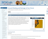
In this activity, students use a seismic hazard map from the USGS …
In this activity, students use a seismic hazard map from the USGS to estimate the ground shaking hazard
Screenshot of seismic hazard map
Provenance: Carla Whittington, Highline Community College Reuse: This item is offered under a Creative Commons Attribution-NonCommercial-ShareAlike license http://creativecommons.org/licenses/by-nc-sa/3.0/ You may reuse this item for non-commercial purposes as long as you provide attribution and offer any derivative works under a similar license. in their community. The map shows a 10% probability of ground accelerations reaching or exceeding a certain % of gravity within the next 50 years. Students then adjust the acceleration value for the soil conditions/geologic materials that their home sits on. Once the acceleration hazard is determined, students equate that hazard to the Mercalli Intensity Scale and investigate the potential damage expected at their homes. Students also take into consideration housing types and the weaknesses inherent in different types/ages of structures.
(Note: this resource was added to OER Commons as part of a batch upload of over 2,200 records. If you notice an issue with the quality of the metadata, please let us know by using the 'report' button and we will flag it for consideration.)
This article highlights science and literacy lessons to teach elementary students about …
This article highlights science and literacy lessons to teach elementary students about erosion, glaciers, volcanoes, and earthquakes. Links to national standards are included.
Students use real seismograms to determine the arrival times for P and …
Students use real seismograms to determine the arrival times for P and S waves and use these times to determine the distance of the seismic station from the earthquake. Seismograms from three stations are provided to determine the epicenter using the S -- P (S minus P) method. Because real seismograms contain some "noise" with resultant uncertainty in locating arrival times of P and S waves, this activity promotes appreciation for uncertainties in interpretation of real scientific data.
(Note: this resource was added to OER Commons as part of a batch upload of over 2,200 records. If you notice an issue with the quality of the metadata, please let us know by using the 'report' button and we will flag it for consideration.)
Every week, numerous potentially damaging earthquakes occur around the world. To demonstrate …
Every week, numerous potentially damaging earthquakes occur around the world. To demonstrate the frequency geography of these earthquakes, you will use U.S. GEOLOGICAL SURVEY's Earthquake Tracker, an online resource, to list the locations / facts of all the magnitude 5.0 or higher earthquakes for the 4-day period. You will record information about the earthquakes (e.g., magnitude, date/time, depth, nearest city) in a word processing document and save as a pdf. Once you have completed this assignment, you will save your file and submit it as an attachment. LEARNING OUTCOMES 1. Successfully interact with the USGS Earthquake Tracker to identify a subset of earthquakes based on magnitude. 2. Understand the relationship between earthquakes and Plate Tectonics.
Through a hands-on activity using salt marsh sediment cores from Pacific Northwest …
Through a hands-on activity using salt marsh sediment cores from Pacific Northwest estuaries, students will learn how these environments record the history of earthquakes and tsunami. Students will analyze the stratigraphy through visualization and touch. Students will additionally conduct an experiment to compare organic matter content within sediment sampled from different depths within the sediment core.
(Note: this resource was added to OER Commons as part of a batch upload of over 2,200 records. If you notice an issue with the quality of the metadata, please let us know by using the 'report' button and we will flag it for consideration.)
In this lab, students investigate a hotly debated topic relevant in the …
In this lab, students investigate a hotly debated topic relevant in the political, economic, and scientific arenas. They will examine the processes involved in unconventional oil and gas resource production, including hydraulic fracturing. In particular, they will examine nearby seismic activity and will be asked to determine if correlations can be established between fluid injection, related to hydrofracking or wastewater disposal, and earthquake activity. As an option, students can also investigate geothermal activity at the Geysers in California, to illustrate the difficulty in assessing natural versus induced seismicity in such a geologically complex region.
In this exercise students will consider various aspects of earthquake seismology methods …
In this exercise students will consider various aspects of earthquake seismology methods that include p-wave amplitude, location of an earthquake epicenter, determining the time of occurrence of an earthquake and the relationships between type of plate boundary and earthquake focal depth. Students will be exposed to several types of graphing program and spreadsheets to analyze and illustrate the results. They will also use seismicity maps and the WWW to reinforce the concepts presented both in the lab and in lecture.
(Note: this resource was added to OER Commons as part of a batch upload of over 2,200 records. If you notice an issue with the quality of the metadata, please let us know by using the 'report' button and we will flag it for consideration.)
Geology is the core discipline of the earth sciences and encompasses many …
Geology is the core discipline of the earth sciences and encompasses many different phenomena, including plate tectonics and mountain building, volcanoes and earthquakes, and the long-term evolution of Earth’s atmosphere, surface and life. Because of the ever-increasing demand for resources, the growing exposure to natural hazards, and the changing climate, geology is of considerable societal relevance. This course introduces students to the basics of geology. Through a combination of lectures, labs, and field observations, we will address topics ranging from mineral and rock identification to the origin of the continents, from geologic mapping to plate tectonics, and from erosion by rivers and glaciers to the history of life.
This text is provided to you as an Open Educational Resource which …
This text is provided to you as an Open Educational Resource which you access online. It is designed to give you a comprehensive introduction to Geology at no or very nominal cost. It contains both written and graphic text material, intra-text links to other internal material which may aid in understanding topics and concepts, intra-text links to the appendices and glossary for tables and definitions of words, and extra-text links to videos and web material that clarifies and augments topics and concepts. Like any new or scientific subject, Geology has its own vocabulary for geological concepts. For you to converse effectively with this text and colleagues in this earth science course, you will use the language of geology, so comprehending these terms is important. Use the intra-text links to the Glossary and other related material freely to gain familiarity with this language.
Faculty who adopt this text for their course should contact the authors at edits@opengeology.org so that the authors can keep faculty users up to date of critical changes.
Students continue their introduction to Excel by building spreadsheets that estimate the …
Students continue their introduction to Excel by building spreadsheets that estimate the risk of a major earthquake along the Cascadia Subduction Zone to Benton County, Oregon.
No restrictions on your remixing, redistributing, or making derivative works. Give credit to the author, as required.
Your remixing, redistributing, or making derivatives works comes with some restrictions, including how it is shared.
Your redistributing comes with some restrictions. Do not remix or make derivative works.
Most restrictive license type. Prohibits most uses, sharing, and any changes.
Copyrighted materials, available under Fair Use and the TEACH Act for US-based educators, or other custom arrangements. Go to the resource provider to see their individual restrictions.