In this activity, students make and manipulate physical shoreline models to discover …
In this activity, students make and manipulate physical shoreline models to discover the features of resilient shorelines and to critically evaluate the impacts of rising seas. Students will use NOAA's Sea Level Rise Viewer to observe a coastal area of interest and predict the consequences of sea level rise on people, the environment, and the economy. Though the curriculum references North Carolina, this lesson will work for all coastal areas.
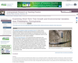
Photo of a tree band at Penn State Brandywine, Media, PA Provenance: …
Photo of a tree band at Penn State Brandywine, Media, PA
Provenance: Laura Guertin, Penn State Brandywine Reuse: This item is offered under a Creative Commons Attribution-NonCommercial-ShareAlike license http://creativecommons.org/licenses/by-nc-sa/3.0/ You may reuse this item for non-commercial purposes as long as you provide attribution and offer any derivative works under a similar license. The Smithsonian Institution's Global Tree Banding Project is a citizen science program that contributes to research about tree biomass by tracking how trees respond to climate. Students around the globe are monitoring the rate at which their local trees grow and learn how that rate corresponds to Smithsonian research as well as comparing the work to other students worldwide. But at Penn State Brandywine, we are going beyond the requirements of the Smithsonian project. Instead of only taking two measurements in the spring and two measurements in the fall, undergraduate researchers are taking measurements every two weeks. We started taking measurements of ten trees on campus April 3, 2012, and we will continue until each and every tree outgrows its tree band. As a result, we have a rich database that not only contributes to scientific research but can serve as a foundation for student inquiry-based projects. The data is available for download in Google Spreadsheets for students to examine changes in tree diameter within one or between growing seasons, supplemented with temperature and precipitation data.
(Note: this resource was added to OER Commons as part of a batch upload of over 2,200 records. If you notice an issue with the quality of the metadata, please let us know by using the 'report' button and we will flag it for consideration.)
In this nine-part exercise, students download NOAA high resolution bathy/topo DEMs and …
In this nine-part exercise, students download NOAA high resolution bathy/topo DEMs and TIGER census data to predict the location of shorelines, the extent of inundation, and the number of people affected by sea level rise as a result of global warming and tsunami in various parts of the coastal US; extensions include developing a Map Book report with data driven pages and locating Pleistocene land bridges. You might also be interested in our Full GIS course with links to all assignments.
(Note: this resource was added to OER Commons as part of a batch upload of over 2,200 records. If you notice an issue with the quality of the metadata, please let us know by using the 'report' button and we will flag it for consideration.)
Using the question of how exercise and sporting events might be affected …
Using the question of how exercise and sporting events might be affected by climate, students are led to the basic questions of what causes climate change, how our climate might change, and what affect that might have on athletes and anyone undertaking strenuous exercise.
(Note: this resource was added to OER Commons as part of a batch upload of over 2,200 records. If you notice an issue with the quality of the metadata, please let us know by using the 'report' button and we will flag it for consideration.)
This resource is a video abstract of a research paper created by …
This resource is a video abstract of a research paper created by Research Square on behalf of its authors. It provides a synopsis that's easy to understand, and can be used to introduce the topics it covers to students, researchers, and the general public. The video's transcript is also provided in full, with a portion provided below for preview:
"Exotic species are a big problem worldwide. While the mechanisms of invasion vary from one exotic species to the next, researchers can tease out patterns that are useful for understanding and ultimately managing invasion. A new study published in the Journal of Biogeography reveals how one team has applied an emerging method known as the phylogenetic field approach to do just that for exotic plants in Japan. The results offer critical insight into how ecology and evolution influence the dynamics of invasion. Darwin’s On the Origin of Species marked the first time biological invasion had been addressed using the principles of evolutionary ecology. But followed to their logical end, these principles yielded two contradictory hypotheses. The pre-adaptation hypothesis states that exotic species successfully colonize assemblages with native species that are ecologically similar because both require the same set of environmental conditions to thrive..."
The rest of the transcript, along with a link to the research itself, is available on the resource itself.
In this video scientists discuss possible rates of sea level rise, storms …
In this video scientists discuss possible rates of sea level rise, storms and resulting damage, rising temperatures and melting ice, and their collective effects on ecosystems.
The Externalities Game is a non-cooperative game that teaches students about the …
The Externalities Game is a non-cooperative game that teaches students about the concept of environmental externalities and allows them to directly experience the moral dimensions of collective action problems. It has been particularly effective for teaching students about the moral aspects of the climate change. Grades are used to create the tension between earning individual grade points at the expense of group benefit. This is part of a research project funded by the National Science Foundation.
(Note: this resource was added to OER Commons as part of a batch upload of over 2,200 records. If you notice an issue with the quality of the metadata, please let us know by using the 'report' button and we will flag it for consideration.)
This course provides an introduction to the atmospheric chemistry involved in climate …
This course provides an introduction to the atmospheric chemistry involved in climate change, air pollution and biogeochemical cycles using a combination of hands-on laboratory, field studies, and simple computer models. Lectures will be accompanied by field trips to collect air samples for the analysis of gases, aerosols and clouds by the students.
Major reports and initiatives by the city and its collaborators are described …
Major reports and initiatives by the city and its collaborators are described here in chronological order, starting in 2007. Use the drop down menu to filter the reports by subject area.
In Massachusetts, Manchester-by-the-Sea's wastewater treatment plant is located right on the coast. …
In Massachusetts, Manchester-by-the-Sea's wastewater treatment plant is located right on the coast. The town's water utility is working with the EPA's Climate Ready Water Utilities program to consider its adaptation options.
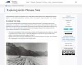
In this activity, students use authentic Arctic climate data to explore albedo …
In this activity, students use authentic Arctic climate data to explore albedo and its relationship to seasonal snowmelt as a self-reinforcing feedback mechanism, which is then applied to large scale global climate change.
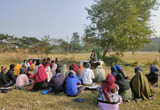
This activity has students work together to summarize regional effects of climate …
This activity has students work together to summarize regional effects of climate change and other environmental issues, which a focus on how these issues may influence agriculture and water availability. Students present a region to the group and create a layperson summary of the effects of climate change and other environmental change on their region.
(Note: this resource was added to OER Commons as part of a batch upload of over 2,200 records. If you notice an issue with the quality of the metadata, please let us know by using the 'report' button and we will flag it for consideration.)
Short Description: When it comes to climate change, studies have shown that …
Short Description: When it comes to climate change, studies have shown that youth are more likely to report mental health concerns in comparison to older generations. Emerging research underlines that youth who enroll in environmental classes consistently report increased levels of stress as a result of their heightened awareness of planetary health challenges. This toolkit is designed for use by educators to empower students to think critically about the structural and socio-political inequities that affect them while centering climate change and mental health through embedded reflective exercises. Questions that explore eco-anxiety, ecological paralysis and ecological grief are included in this toolkit. Students are encouraged to answer questions according to the emotions that they resonate most with and want to explore further. Additionally, students are encouraged to examine the relationship between anthropogenic activity, mental health and their values, emotions and behaviours. The PDF version of this toolkit is available for download here: https://pressbooks.bccampus.ca/eccmh/wp-content/uploads/sites/1644/2022/04/2April2022_TOOLKIT_Exploring-Mental-Health-and-Climate-Change_compressed-1.pdf.
Long Description: When it comes to climate change, studies have shown that youth are more likely to report mental health concerns in comparison to older generations. Emerging research underlines that youth who enroll in environmental classes consistently report increased levels of stress as a result of their heightened awareness of planetary health challenges. Unfortunately, though there are increasing numbers of people who will be affected by the mental health impacts of climate change, factors such as psychological distance and denial influence the way individuals form their beliefs and take action on this issue. In response to the need for more innovative teaching tools in undergraduate curricula, as well as the eagerness of youth to learn about planetary health, a 25-minute film and accompanying toolkit were created focusing on the relationship between mental health and climate change. In addition to climate change experts, the film features UBC students who were previously enrolled in the UBC nursing elective course NURS 290: Health Impacts of Climate Change. The educational toolkit uses knowledge mobilization and health promotion strategies based on the Transtheoretical Model of Change. The film and toolkit are tools designed for use by educators to empower students to think critically about the structural and socio-political inequities that affect them while centering climate change and mental health through embedded reflective exercises. By featuring the voices of students, this project is not only relevant and impactful but also addresses the diverse learning needs of students. The PDF version of this toolkit is available for download here.
Word Count: 2242
(Note: This resource's metadata has been created automatically by reformatting and/or combining the information that the author initially provided as part of a bulk import process.)
Exploring Climate Science With Virtual Reality, a Teacher/Scientist Partnership experience. High school …
Exploring Climate Science With Virtual Reality, a Teacher/Scientist Partnership experience. High school teachers engage with working scientists and engineers to for content learning for climate science and virtual reality and engage in follow-up sessions with professional development facilitators to develop pedagogical expertise for use in creating formative classroom tasks that are formative and productive. It is a three day initial workshop with four follow-up days to 1) deepen teacher understanding by learning with climate scientists to understand climate science standards content knowledge 2) increase awareness and knowledge of the use of virtual reality devices in climate science learning 30 to co-develop a climate science simulation game for use on Oculus Go devices with teachers, their students and a virtual reality scientist/engineer team 4) to develop and implement embedded formative classroom tasks that complement climate science learning by using a relevant, place based phenomena, and provide insights into student thinking and productive next steps in learning.
Creative Commons License CC BY Exploring Climate Science With Virtual Reality Professional Learning Module by Georgia Boatman, ESD 123 and Peggy Willcuts PNNL is licensed under a Creative Commons Attribution 4.0 International License.
Climate change has been at the forefront of discussions in the last …
Climate change has been at the forefront of discussions in the last couple of decades. Whilst some people are at the privileged position that they hardly ever feel the impact of climate change, there are others who face these issues as everyday reality. When it comes to documenting people’s lived experiences, nothing comes close to literary portrayals. Therefore, this lesson plan outlines how a group of 30 tertiary level students can be introduced to the idea of ecocriticism and how they can build their eco-consciousness through understanding different eco-disasters as narrated in Amitav Ghosh’s The Great Derangement. The lesson plan also includes tasks of creative writing and translating eco-literature.
In this lesson, students complete a Myers-Briggs Type Inventory of their personality …
In this lesson, students complete a Myers-Briggs Type Inventory of their personality type as an introductory step to understanding what green jobs might suit their personal styles. From the information on this online tool, they look at different green jobs to explore possible careers.
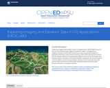
ìExploring Imagery and Elevation Data in GIS Applicationsî (GEOG 480) focuses on …
ìExploring Imagery and Elevation Data in GIS Applicationsî (GEOG 480) focuses on the use of remotely sensed imagery and elevation data in GIS applications. Students enrolling in GEOG 480 should have a solid conceptual foundation in geospatial information science and technology. GEOG 480 is appropriate for those who are already working in the geospatial profession and wish to use imagery and elevation data in visualization and spatial analysis. Throughout the course, students confront realistic remote sensing problem scenarios that incorporate such skills and concepts as definition of data needs, metadata content standards, data formats and types, and analysis methods.
This Earth Exploration Toolbook chapter uses ArcGIS and climate data from the …
This Earth Exploration Toolbook chapter uses ArcGIS and climate data from the National Center for Atmospheric Research (NCAR) Climate Change Scenarios GIS Data Portal to help users learn the basics of GIS-based climate modeling. The five-part exercise involves calculating summer average temperatures for the present day and future climate modeled output, visually comparing the temperature differences for the two model runs, and creating a temperature anomaly map to highlight air temperature increases or decreases around the world.
The lesson will begin by students accessing their prior knowledge of weather …
The lesson will begin by students accessing their prior knowledge of weather and climates by completing a warm-up writing prompt. Students will then move to reading texts on the subjects of tornadoes, hurricanes, earthquakes, and droughts to determine if and how climate affects these weather phenomena. In groups, students will create a half-poster that describes their findings in text and pictures. At the end of the lesson, students will view a graph to extend their learning about tornadoes and hint at a future lesson while also completing an "exit ticket" as a means of summative assessment. This unit was created as part of the ALEX Interdisciplinary Resource Development Summit.
No restrictions on your remixing, redistributing, or making derivative works. Give credit to the author, as required.
Your remixing, redistributing, or making derivatives works comes with some restrictions, including how it is shared.
Your redistributing comes with some restrictions. Do not remix or make derivative works.
Most restrictive license type. Prohibits most uses, sharing, and any changes.
Copyrighted materials, available under Fair Use and the TEACH Act for US-based educators, or other custom arrangements. Go to the resource provider to see their individual restrictions.