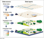
As if they are environmental engineers, student pairs are challenged to use Google Earth Pro (free) GIS software to view and examine past data on hurricanes and tornados in order to (hypothetically) advise their state government on how to proceed with its next-year budget—to answer the question: should we reduce funding for natural disaster relief? To do this, students learn about maps, geographic information systems (GIS) and the global positioning system (GPS), and how they are used to deepen the way maps are used to examine and analyze data. Then they put their knowledge to work by using the GIS software to explore historical severe storm (tornado, hurricane) data in depth. Student pairs confer with other teams, conduct Internet research on specific storms and conclude by presenting their recommendations to the class. Students gain practice and perspective on making evidence-based decisions. A slide presentation as well as a student worksheet with instructions and questions are provided.
- Subject:
- Applied Science
- Computer Science
- Engineering
- Mathematics
- Physical Science
- Statistics and Probability
- Material Type:
- Activity/Lab
- Provider:
- TeachEngineering
- Provider Set:
- Activities
- Author:
- Kent Kurashima
- Date Added:
- 02/27/2018


