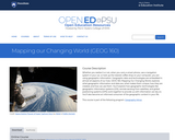
As if they are environmental engineers, student pairs are challenged to use …
As if they are environmental engineers, student pairs are challenged to use Google Earth Pro (free) GIS software to view and examine past data on hurricanes and tornados in order to (hypothetically) advise their state government on how to proceed with its next-year budget—to answer the question: should we reduce funding for natural disaster relief? To do this, students learn about maps, geographic information systems (GIS) and the global positioning system (GPS), and how they are used to deepen the way maps are used to examine and analyze data. Then they put their knowledge to work by using the GIS software to explore historical severe storm (tornado, hurricane) data in depth. Student pairs confer with other teams, conduct Internet research on specific storms and conclude by presenting their recommendations to the class. Students gain practice and perspective on making evidence-based decisions. A slide presentation as well as a student worksheet with instructions and questions are provided.
Study of physical effects in the vicinity of a black hole as …
Study of physical effects in the vicinity of a black hole as a basis for understanding general relativity, astrophysics, and elements of cosmology. Extension to current developments in theory and observation. Energy and momentum in flat spacetime; the metric; curvature of spacetime near rotating and nonrotating centers of attraction; trajectories and orbits of particles and light; elementary models of the Cosmos. Weekly meetings include an evening seminar and recitation. The last third of the semester is reserved for collaborative research projects on topics such as the Global Positioning System, solar system tests of relativity, descending into a black hole, gravitational lensing, gravitational waves, Gravity Probe B, and more advanced models of the Cosmos.
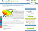
In this activity students will learn the basic concept of Global Positioning …
In this activity students will learn the basic concept of Global Positioning Systems (GPS) using triangulation and measurement on a small scale in the classroom. Students discover how GPS and navigation integrate mathematic and scientific concepts to create a standard for locating people and objects. This activity helps students understand both the need for and methods of navigation.
The concept of geocaching is introduced as a way for students to …
The concept of geocaching is introduced as a way for students to explore using a global positioning system (GPS) device and basic geographic information (GIS) skills. Students familiarize themselves with GPS, GIS, and geocaching as well as the concepts of latitude and longitude. They develop the skills and concepts needed to complete the associated activity while considering how these technologies relate to engineering. Students discuss images associated with GPS, watch a video on how GPS is used, and review a slide show of GIS basics. They estimate their location using latitude and longitude on a world map and watch a video that introduces the geocaching phenomenon. Finally, students practice using a GPS device to gain an understanding of the technology and how location and direction features work while sending and receiving data to a GIS such as Google Earth.
Students design their own logo or picture and use a handheld GPS …
Students design their own logo or picture and use a handheld GPS receiver to map it out. They write out a word or graphic on a field or playground, walk the path, and log GPS data. The results display their "art" on their GPS receiver screen.
Students familiarize themselves â through trial and error â with the basics …
Students familiarize themselves â through trial and error â with the basics of GPS receiver operation. They view a receiver's satellite visibility screen as they walk in various directions and monitor their progress on the receiver's map. Students may enter waypoints and use the GPS information to guide them back to specific locations.
Students go on a GPS scavenger hunt. They use GPS receivers to …
Students go on a GPS scavenger hunt. They use GPS receivers to find designated waypoints and report back on what they found. They compute distances between waypoints based on the latitude and longitude, and compare with the distance the receiver finds.
This is a freshman advising seminar. The professor of a FAS is …
This is a freshman advising seminar. The professor of a FAS is the first year advisor to the (no more than 8) students in the seminar. The use of Global Positioning System (GPS) in a wide variety of applications has exploded in the last few years. In this seminar we explore how positions on the Earth were determined before GPS; how GPS itself works and the range of applications in which GPS is now a critical element. This seminar is followed by a UROP research project in the spring semester where results from precise GPS measurements will be analyzed and displayed on the Web.
During a scavenger hunt and an art project, students learn how to …
During a scavenger hunt and an art project, students learn how to use a handheld GPS receiver for personal navigation. Teachers can request assistance from the Institute of Navigation to find nearby members with experience in using GPS and in locating receivers to use.
In past times, ocean navigators tossed a piece of wood over the …
In past times, ocean navigators tossed a piece of wood over the side of their ships and noted how long until the ship passed the wood. They used this time measurement and the length of the ship to calculate their speed and estimate how far they had traveled. In this activity, students act the part of a GPS signal traveling to the receiver to learn how travel time is converted to distance.
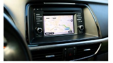
Whether you realize it or not, when you carry a smart phone, …
Whether you realize it or not, when you carry a smart phone, use a navigation system in your car, or look up the nearest coffee shop on your computer, you are using geographic information. Geographic data and technologies are embedded in almost all aspects of our lives. GEOG 160, Mapping Our Changing World, explores what geographic information and data are, what makes them unique, how they are created, and how we use them. You'll explore how geographic technologies like geographic information systems (GIS), remote sensing from satellites, and global positioning systems (GPS) work together to provide us with information we rely on. You'll also become an informed consumer of the geographic content in your life.
This course introduces the concepts and applications of navigation techniques using celestial …
This course introduces the concepts and applications of navigation techniques using celestial bodies and satellite positioning systems such as the Global Positioning System (GPS). Topics include astronomical observations, radio navigation systems, the relationship between conventional navigation results and those obtained from GPS, and the effects of the security systems, Selective Availability, and anti-spoofing on GPS results. Laboratory sessions cover the use of sextants, astronomical telescopes, and field use of GPS. Application areas covered include ship, automobile, and aircraft navigation and positioning, including very precise positioning applications.
For thousands of years, navigators have looked to the sky for direction. …
For thousands of years, navigators have looked to the sky for direction. Today, celestial navigation has simply switched from using natural objects to human-created satellites. A constellation of satellites, called the Global Positioning System, and hand-held receivers allow for very accurate navigation. In this lesson, students investigate the fundamental concepts of GPS technology trilateration and using the speed of light to calculate distances.
In this unit, students learn the very basics of navigation, including the …
In this unit, students learn the very basics of navigation, including the different kinds of navigation and their purposes. The concepts of relative and absolute location, latitude, longitude and cardinal directions are explored, as well as the use and principles of maps and a compass. Students discover the history of navigation and learn the importance of math and how it ties into navigational techniques. Understanding how trilateration can determine one's location leads to a lesson on the global positioning system and how to use a GPS receiver. The unit concludes with an overview of orbits and spacecraft trajectories from Earth to other planets.
In this project, you will explore a real-world problem, and then work …
In this project, you will explore a real-world problem, and then work through a series of steps to analyze that problem, research ways the problem could be solved, then propose a possible solution to that problem. Often, there is no specific right or wrong solutions, but sometimes one particular solution may be better than others. The key is making sure you fully understand the problem, have researched some possible solutions, and have proposed the solution that you can support with information / evidence.Begin by reading the problem statement in Step 1. Take the time to review all of the information provided in the statement, including exploring the websites, videos and / or and articles that are linked. Then work on steps 2 through 8 to complete this problem-based learning experience.
To navigate, you must know roughly where you stand relative to your …
To navigate, you must know roughly where you stand relative to your designation, so you can head in the right direction. In locations where landmarks are not available to help navigate (in deserts, on seas), objects in the sky are the only reference points. While celestial objects move fairly predictably, and rough longitude is not too difficult to find, it is not a simple matter to determine latitude and precise positions. In this activity, students investigate the uses and advantages of modern GPS for navigation.
In this lesson, students are shown the very basics of navigation. The …
In this lesson, students are shown the very basics of navigation. The concepts of relative and absolute location, latitude, longitude and cardinal directions are discussed, as well as the use and principles of a map and compass.
No restrictions on your remixing, redistributing, or making derivative works. Give credit to the author, as required.
Your remixing, redistributing, or making derivatives works comes with some restrictions, including how it is shared.
Your redistributing comes with some restrictions. Do not remix or make derivative works.
Most restrictive license type. Prohibits most uses, sharing, and any changes.
Copyrighted materials, available under Fair Use and the TEACH Act for US-based educators, or other custom arrangements. Go to the resource provider to see their individual restrictions.