In this unit, students explore water privatization and freshwater access issues within …
In this unit, students explore water privatization and freshwater access issues within the geophysical and cultural context of Cochabamba, Bolivia. Students identify topographical features that create rain shadows and their relationship to the water cycle. As they discuss several alternative models for supplying water to the residents of Cochabamba, they link concepts of environmental justice to the Cochabamba Water Wars of 2000.
(Note: this resource was added to OER Commons as part of a batch upload of over 2,200 records. If you notice an issue with the quality of the metadata, please let us know by using the 'report' button and we will flag it for consideration.)
The assignment is to calculate an annual water balance for a tree …
The assignment is to calculate an annual water balance for a tree using data gathered at the Southern Sierra Critical Zone Observatory. In the framework of experimental design, students will organize around a research question "Is there enough water in the soil to account for transpiration?" After gathering and organizing data, students will calculate the annual water fluxes and reservoirs using a mass balance approach. Later these lessons can be expanded to catchment-scale calculations.
(Note: this resource was added to OER Commons as part of a batch upload of over 2,200 records. If you notice an issue with the quality of the metadata, please let us know by using the 'report' button and we will flag it for consideration.)
Units 3 and 4 of this module explored how water resources are …
Units 3 and 4 of this module explored how water resources are used for agriculture in the United States and how this can vary depending on location. In Unit 5, students explore how agricultural practices can affect the water quality in streams, rivers, lakes, and coastal areas. Important concepts in this unit include processes that transport suspended material (e.g., sediment) and dissolved material (e.g., nutrients) away from crop fields and into regional water bodies. The effects of dissolved nutrients on the health of the water ecosystems will be presented with examples of hypoxic zones in coastal areas and lake eutrophication. This last unit is well-suited to foster student advancement in systems thinking.
(Note: this resource was added to OER Commons as part of a batch upload of over 2,200 records. If you notice an issue with the quality of the metadata, please let us know by using the 'report' button and we will flag it for consideration.)
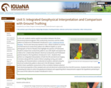
Screenshot of the slider tool used to relate geophysical images to vegetation …
Screenshot of the slider tool used to relate geophysical images to vegetation pattern
Provenance: Lee Slater, Rutgers University-Newark Reuse: This item is in the public domain and maybe reused freely without restriction. In this unit, students explore spatial associations between the three-dimensional electromagnetic (EM) conductivity inversions and the visible patterns of Salicornia (Pickleweed) introduced in Unit 1, Exploring Harrier Meadow. The Arcview Storymap started in Unit 1 allows students to overlay inverted electrical conductivity patterns for different depths on aerial photographs of Harrier Meadow that highlight the patches of Pickleweed. Students analyze how conductivity patterns vary with depth and explore for evidence for a relationship between electrical conductivity and Pickleweed patches based on the hypothesis introduced in Unit 1. Students then perform an integrated interpretation of both the EM and electrical imaging inversions along with the results of direct sampling (coring, pore water sampling, soil characterization) conducted at locations selected using the electrical conductivity patterns observed in the EM dataset. Students perform basic qualitative assessments of the correlation between physical and chemical properties of the sampled soils and soil electrical conductivity from the EM inversions. Students finish the module by evaluating the extent to which the geophysical dataset and supporting direct measurements support the hypothesis pertaining to the cause of the Salicornia clusters introduced in Unit 1.
(Note: this resource was added to OER Commons as part of a batch upload of over 2,200 records. If you notice an issue with the quality of the metadata, please let us know by using the 'report' button and we will flag it for consideration.)
In this unit, students will learn about the dynamic movement of nutrients …
In this unit, students will learn about the dynamic movement of nutrients among and within ecosystems primarily through the reading and discussion of scientific literature. This unit is generally subdivided into three sections: (1) allochthonous inputs (2) the role of organisms in biogeochemical cycles and how ecological theory can be applied to biogeochemistry and (3) how biogeochemical processes can assist in creating solutions for humanity's grand challenges. This unit is designed to provide students with the opportunity to develop their reading and interpretation of scientific literature. Students will also become familiar with the utility of isotopic techniques and their use in biogeochemistry through readings and data analysis of carbon and nitrogen isotopic data sets. Chosen scientific articles are provided, each with their own set of reading questions. Additionally, short introductory materials are provided to introduce students to some of the general concepts and processes in the study of biogeochemistry.
(Note: this resource was added to OER Commons as part of a batch upload of over 2,200 records. If you notice an issue with the quality of the metadata, please let us know by using the 'report' button and we will flag it for consideration.)
In this week-long unit students will explore Critical Zone function and dynamics …
In this week-long unit students will explore Critical Zone function and dynamics as they relate to nutrient cycling in agricultural systems and nutrient pollution into aquatic systems. This unit is generally subdivided into three sections: (1) nutrient pollution (2) agricultural importance and (3) Critical Zone function and dynamics in relation to nutrient cycling. The students will use data sets, interactive activities, primary literature, and videos to allow them to examine the role that the CZ plays and how that role changes with differing land uses. Important present-day topics of food production, clean water, nutrient pollution, and sustainable agriculture are examined using a CZ lens. Students will interact with each other on a variety of scales (individual, small groups, entire class) and using a variety of modes (presentations, written reports, question and answers, and class discussion) in this unit. Additionally, optional activities are provided if lab activities are able to be accommodated. The unit ends with a summative assessment assignment that is based on an innovative call for proposals to combat one of America's most widespread, costly, and challenging environmental problems: nutrient pollution.
(Note: this resource was added to OER Commons as part of a batch upload of over 2,200 records. If you notice an issue with the quality of the metadata, please let us know by using the 'report' button and we will flag it for consideration.)
Students are introduced to the concept of geoengineering, "the deliberate large-scale intervention …
Students are introduced to the concept of geoengineering, "the deliberate large-scale intervention in the Earth's climate system, in order to moderate global warming" (The Royal Society). The goal is for them to leverage their acquired knowledge from previous units in physical oceanography, ocean chemistry, biodiversity, and ecosystem ecology to evaluate the validity and/or the risk of geoengineering (systems thinking). Current and future generations will be required to make informed decisions on whether they support strategies that result in irreversible changes in Earth's carbon cycle.
(Note: this resource was added to OER Commons as part of a batch upload of over 2,200 records. If you notice an issue with the quality of the metadata, please let us know by using the 'report' button and we will flag it for consideration.)
In preparation for the activity a lecture is given on the properties …
In preparation for the activity a lecture is given on the properties and history of polychlorinated biphenyls and other contaminants. Each student is assigned to one of six groups with an interest in the outcome of the debate. The teams must meet and prepare a position paper on the proposed environmental dredging in the Upper Hudson River. Each team must represent the interests of its assigned constituency. Data and background information is found on the world wide web and from the instructor's collection of related articles. On the day of the debate the student's orally present their position paper (some make posters or powerpoint presentations). After each group has made their opening statement the invited guest senators on the panel (other faculty, myself, interested students, those who were absent for the preparation) ask each group a series of questions related to their stance. After this a general debate begins with detailed and sometimes heated discussions between the groups and the panel. A few moments are saved at the end of class and everyone is allowed to drop their assumed affiliation and speak their mind on what should be done. Before leaving the class is give a series of big picture topics to think about over the weekend and these are discussed during the next class.
(Note: this resource was added to OER Commons as part of a batch upload of over 2,200 records. If you notice an issue with the quality of the metadata, please let us know by using the 'report' button and we will flag it for consideration.)
This module looks at the feasibility of using deeper wells as a …
This module looks at the feasibility of using deeper wells as a source of low As water. The data sets are described in detail by van Geen et al. (van Geen et al., 2003; van Geen et al., 2002).
Students are being introduced to background information about the Arsenic problem in Bangladesh in lecture format. This includes health aspects and the history of the issue. They also have been using the sand tank groundwater model distributed by the University of Wisconsin Stevens Point (https://www.uwsp.edu/cnr-ap/watershed/Pages/GroundwaterModelWorkshop.aspx) to develop an intuitive understanding of groundwater flow and transport and are familiar with basic hydrogeological concepts. They inject a dye into the shallow aquifer of the model and study how pumping effects the migration of the Arsenic plume (Fig 1).
Students get an Excel spreadsheet that contains the longitude, latitude, and depth of 6000 wells and a satellite image that shows the area of investigation. They use Arc GIS software to plot data on the satellite image (Fig. 2), or alternatively plot the data as a function of longitude and latitude as a bubble plot in Excel. They find that the distribution of As in many regions is very heterogeneous. They then select sub-regions and look at the depth distribution and find that often there is a gap in the depth population of wells which turns out to be due to a clay layer varying in thickness that separates the shallow aquifer from the deep aquifer. The depth distribution (Fig. 3) of As also shows a characteristic pattern with most of the elevated As concentrated in the top 30 meters. Students then discuss remediation options, in particular the possibility of switching to neighboring wells and using deeper groundwater as an alternative source of drinking water. They find that in many regions there are safe wells within a few hundred m of the high As well. However, it is not clear how long these wells will remain low in dissolved As and there are social barriers as well to use the neighbors well. They then determine a depth below which As concentrations are low in their region and elevate the risk of using deeper groundwater for drinking water and irrigation. They find that personal use is resulting in only ~1cm year-1 of water use, while irrigation (~1 m year-1) would considerably lower the water table and potentially could contaminate the deeper aquifer as well. The conclusion is that if deeper groundwater is utilized its use should be limited to personal use.
(Note: this resource was added to OER Commons as part of a batch upload of over 2,200 records. If you notice an issue with the quality of the metadata, please let us know by using the 'report' button and we will flag it for consideration.)
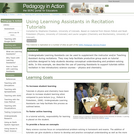
Undergraduate Learning Assistants can be used to supplement the instructor and/or Teaching …
Undergraduate Learning Assistants can be used to supplement the instructor and/or Teaching Assistant during recitations. They may help facilitate productive group work on tutorial activities designed to help students develop conceptual understanding and problem-solving skills. In this example, we describe the use of Learning Assistants to support tutorials within recitation in two introductory science courses physics and chemistry.
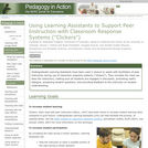
Learning Assistants are used to facilitate student discussion in peer instruction during …
Learning Assistants are used to facilitate student discussion in peer instruction during clicker questions (i.e., classroom response systems), by asking Socratic questions, emphasizing reasoning, and probing student thinking.
I presented the short case studies at the Teaching Hydrogeology workshop to …
I presented the short case studies at the Teaching Hydrogeology workshop to illustrate the five fundamental points I emphasize in my basic hydrogeology class. These five points are what consultants tell me my students should know cold; what the difference is between the water table and potentiometric head, that a contaminant plume from an individual source should be narrow, that water table maps should be related to the topography, that major dissolved species are important to know about, and that organic matter conditions a lot of contaminant transport. How to apply this knowledge where there is scant data is the rub, and I draw from my consulting files to illustrate how I, at least, do it.
(Note: this resource was added to OER Commons as part of a batch upload of over 2,200 records. If you notice an issue with the quality of the metadata, please let us know by using the 'report' button and we will flag it for consideration.)
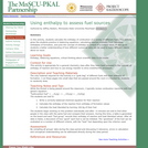
A variety of fuels are evaluated for the amount of heat they …
A variety of fuels are evaluated for the amount of heat they liberate upon burning. This includes a discussion of how different criteria can influence the evaluation of what makes a "good" fuel.
The assignment will begin with teaching proper water collection and use of …
The assignment will begin with teaching proper water collection and use of equipment for hydrochemical field work. Once the class is familiar with sample collecting technques, the class takes a field trip to several springs within the Madera Limestone, Sandia Mountains New Mexico. Collecting waters and obtaining hydrochemical field parameters for each spring location as well as collecting groundwater from one well in the same aquifer. Returning to the lab and preparing and running samples for ion analysis.
Spring waters will then be compared to well water and average precipitation data available from the USGS. Geochemical modeling will then be completed to understand the proportion of aquifer, precipitation and possible deeply sourced waters found in the spring waters.
The outcomes include 1) teaching proper sampling techniques 2) proper preparation of samples for ion analysis 3) Geochemical modeling to understand mixing
(Note: this resource was added to OER Commons as part of a batch upload of over 2,200 records. If you notice an issue with the quality of the metadata, please let us know by using the 'report' button and we will flag it for consideration.)
Show credits HidePu'u 'O'o at the end of episode 32 (USGS photograph …
Show credits HidePu'u 'O'o at the end of episode 32 (USGS photograph by J.D. Griggs, 4/22/85, JG5363). This is an exercise that is in development and has not yet been fully tested in the classroom. Please check back regularly for updates and changes.
Goals of this lab are to: (1) gain background on volcano monitoring using maps, photographs, and geochemical, deformation (tiltmeter) and seismic data from eruptive activity of the Pu'u 'Ō'ō eruption; (2) make and interpret geochemical, deformation and seismic data plots as part of a time-series analysis for particular intervals of eruptive activity; and (3) answer questions and discuss information about magmatic and structural processes associated with volcanism at Kīlauea Volcano.
Brief description of the activity
The current eruption of Kīlauea Volcano on the island of Hawai'i has been closely monitored and studied since its inception in 1983. This laboratory exercise utilizes the excitement of an ongoing eruption to demonstrate volcano monitoring, deformation, and magmatic processes to better understand an active hotspot volcano.
(Note: this resource was added to OER Commons as part of a batch upload of over 2,200 records. If you notice an issue with the quality of the metadata, please let us know by using the 'report' button and we will flag it for consideration.)
In this problem set students are provided with an EXCEL spreadsheet containing …
In this problem set students are provided with an EXCEL spreadsheet containing major element analyses of lavas frm Thingmuli Volcano in Iceland. They are asked to construct variation diagrams (Harker plots) and then explain the trends they see for various elements. I use this problem set to introduce the use of EXCEL and to help students to think about the connections between mineral assemblage and rock chemistry.
(Note: this resource was added to OER Commons as part of a batch upload of over 2,200 records. If you notice an issue with the quality of the metadata, please let us know by using the 'report' button and we will flag it for consideration.)
Undergraduate Learning Assistants have been used to facilitate group work in a …
Undergraduate Learning Assistants have been used to facilitate group work in a variety of ways, such as in-lecture tutorials and worksheets, group work in required recitations, and group work in optional co-seminars. This page describes some of these various ways that Learning Assistants can be used to help make a course more interactive.
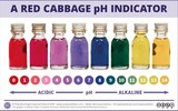
This is a virtual adaptation of a buffer capacity lab experiment using …
This is a virtual adaptation of a buffer capacity lab experiment using the chemcollective digital workspace. Students learn to make buffers in different ways and then test the capacity of their buffers to understand what makes an optimal buffer.
A primary objective of marine science classes is to learn the location …
A primary objective of marine science classes is to learn the location and formation of ocean sediment types. Nearly 50 years of scientific ocean drilling has produced a tremendous scientific collection of cores from the global ocean floor. In addition, there are large online databases and related publications that have a wealth of associated information to supplement physical cores. Here we created a virtual marine core collection that provides exemplars of the primary ocean sediment lithologies, along with links to expedition reports and datasets, and tips for making requests for real core samples to use in education.
(Note: this resource was added to OER Commons as part of a batch upload of over 2,200 records. If you notice an issue with the quality of the metadata, please let us know by using the 'report' button and we will flag it for consideration.)
No restrictions on your remixing, redistributing, or making derivative works. Give credit to the author, as required.
Your remixing, redistributing, or making derivatives works comes with some restrictions, including how it is shared.
Your redistributing comes with some restrictions. Do not remix or make derivative works.
Most restrictive license type. Prohibits most uses, sharing, and any changes.
Copyrighted materials, available under Fair Use and the TEACH Act for US-based educators, or other custom arrangements. Go to the resource provider to see their individual restrictions.