Updating search results...

Search Resources

507 Results

View
Selected filters:
  • Hydrology
Geo Sandbox Water Budget
Conditional Remix & Share Permitted
CC BY-NC-SA
Rating
0.0 stars

During this activity, the instructor introduces a miniature watershed, named a GeoSandbox, to provide a conceptual bridge between the schema created in the soup can water budget activity and the schoolyard watershed activity to follow. Students introduce known quantities of water to the GeoSandbox using spray bottles and measure the resulting surface flow and infiltration. The concepts of topography and land use are also introduced. Additional instructional materials are provided to firmly establish the concept of a watershed for students who need the support.

Subject:
Applied Science
Environmental Science
Geology
Hydrology
Physical Geography
Physical Science
Material Type:
Activity/Lab
Provider:
Science Education Resource Center (SERC) at Carleton College
Provider Set:
Teach the Earth
Author:
Jason Cervenec
Date Added:
01/20/2023
Geographic Information Systems (GIS) and Water Resources
Conditional Remix & Share Permitted
CC BY-NC-SA
Rating
0.0 stars

This exercise posits a hypothetical situation: you would like to purchase land that will provide your family with opportunities to fish and swim in a stream on your property. Additionally, you would like the land to afford some privacy. In order to find such a place, you need to locate land for sale that has a stream running through it and you want to confirm that the stream water is clean. The following activity illustrates how one can locate land with particular characteristics and also assess surface water quality for local bodies of water. The data you will use might pertain to any location where streams flow through residential areas.

(Note: this resource was added to OER Commons as part of a batch upload of over 2,200 records. If you notice an issue with the quality of the metadata, please let us know by using the 'report' button and we will flag it for consideration.)

Subject:
Business and Communication
Career and Technical Education
Chemistry
Environmental Studies
Hydrology
Management
Physical Science
Political Science
Social Science
Material Type:
Activity/Lab
Provider:
Science Education Resource Center (SERC) at Carleton College
Provider Set:
Teach the Earth
Author:
Constantin Cranganu
Date Added:
11/04/2021
Geography of Water Resources
Conditional Remix & Share Permitted
CC BY-NC-SA
Rating
0.0 stars

Geography 431 is designed to further understanding of the natural processes of aquatic ecosystems, management of water resources, and threats to sustaining water quantity. Develop awareness and appreciation of the perspectives about water as a precious resource, commodity, and sometimes hazard. Learn how and why water is distributed unevenly around the Earth. Examine how resource management decisions are strongly related to water availability, quantity, and quality. The course examines water resources management; dams and dam removal; provision of safe potable water; threats to water quantity and quality; land use changes; the water economy; water laws and policy; institutions for water management at the global, national, regional, and local scale; and issues of water security and climate change.

Subject:
Applied Science
Ecology
Environmental Science
Hydrology
Life Science
Physical Geography
Physical Science
Material Type:
Full Course
Provider:
Penn State College of Earth and Mineral Sciences
Author:
Jamie Peeler
Michael Nassry
Rob Brooks
Date Added:
10/07/2019
Geomorphology of the  Eastern Snake River Plain
Conditional Remix & Share Permitted
CC BY-NC-SA
Rating
0.0 stars

This two-week long laboratory exercise examines the linkages between the endogenic (tectonic and isostatic) and exogenic processes that created the Eastern Snake River Plain (ESRP) landscape. The landform analysis portion of the exercise focuses upon recent basaltic volcanism and the Menan Buttes, the St. Anthony dunes and the fluvial drainage patterns that developed in the region.

Subject:
Geology
Hydrology
Physical Science
Material Type:
Activity/Lab
Provider:
Science Education Resource Center (SERC) at Carleton College
Provider Set:
Teach the Earth
Author:
David Franzi
Date Added:
01/20/2023
Google Earth and Meandering Rivers
Conditional Remix & Share Permitted
CC BY-NC-SA
Rating
0.0 stars

This exercise takes advantage of student's interest in Google Earth to teach some basic concepts about meandering rivers. Students prepare for class by reading about lowland rivers and/or hearing a lecture on them. They bring their own laptops to class or share with a partner or I take the entire class to the computer lab next door. In class they work through the worksheet and use Google Earth to take quantitative measurements of the rivers. They look at historic migration of meander bends and quantify river sinuousity, wavelength, amplitude, and radius of curvature of meander bends. They explore meandering bedrock rivers in Taiwan as a cool thought exercise in how that can happen. They end with looking at images from an area that they will have a field trip to during their next lab period. To keep people from flying through the exercise and getting bored, we do the whole activity in think-pair-share style. Students work on a location, answer the questions, and then we discuss it as a class.

(Note: this resource was added to OER Commons as part of a batch upload of over 2,200 records. If you notice an issue with the quality of the metadata, please let us know by using the 'report' button and we will flag it for consideration.)

Subject:
Biology
Hydrology
Life Science
Physical Science
Material Type:
Activity/Lab
Provider:
Science Education Resource Center (SERC) at Carleton College
Provider Set:
Teach the Earth
Author:
Amanda Schmidt
Date Added:
09/11/2020
The Grand Canyon: Its Youngest Rocks
Read the Fine Print
Educational Use
Rating
0.0 stars

This video segment adapted from NOVA features the youngest rock formations in the Grand Canyon, lava dams, and how they are subject to the eroding power of water.

Subject:
Astronomy
Chemistry
Education
Geology
Geoscience
Hydrology
Physical Geography
Physical Science
Physics
Space Science
Material Type:
Activity/Lab
Diagram/Illustration
Provider:
PBS LearningMedia
Provider Set:
PBS Learning Media: Multimedia Resources for the Classroom and Professional Development
Author:
National Science Foundation
WGBH Educational Foundation
Date Added:
10/21/2005
Gravity-Fed Water System for Developing Communities
Read the Fine Print
Educational Use
Rating
0.0 stars

Students learn about water poverty and how water engineers can develop appropriate solutions to a problem that is plaguing nearly a sixth of the world's population. Students follow the engineering design process to design a gravity-fed water system. They choose between different system parameters such as pipe sizes, elevation differentials between entry and exit pipes, pipe lengths and tube locations to find a design that provides the maximum flow and minimum water turbidity (cloudiness) at the point of use. In this activity, students play the role of water engineers by designing and building model gravity-fed water systems, learning the key elements necessary for viable projects that help improve the lives people in developing communities.

Subject:
Applied Science
Engineering
Hydrology
Physical Science
Material Type:
Activity/Lab
Provider:
TeachEngineering
Provider Set:
TeachEngineering
Author:
Janet Yowell
Jeff Walters
Malinda Schaefer Zarske
Date Added:
10/14/2015
The Great Flood of 1993
Read the Fine Print
Educational Use
Rating
0.0 stars

In this video segment adapted from NOVA, a meteorologist explains how an unusual weather pattern led to one of the most devastating floods of this century.

Subject:
Hydrology
Physical Science
Material Type:
Activity/Lab
Diagram/Illustration
Provider:
PBS LearningMedia
Provider Set:
PBS Learning Media: Multimedia Resources for the Classroom and Professional Development
Author:
National Science Foundation
WGBH Educational Foundation
Date Added:
12/17/2005
Green Infrastructure and Low-Impact Development Technologies
Read the Fine Print
Educational Use
Rating
0.0 stars

Students are introduced to innovative stormwater management strategies that are being used to restore the hydrology and water quality of urbanized areas to pre-development conditions. Collectively called green infrastructure (GI) and low-impact development (LID) technologies, they include green roofs and vegetative walls, bioretention or rain gardens, bioswales, planter boxes, permeable pavement, urban tree canopy, rainwater harvesting, downspout disconnection, green streets and alleys, and green parking. These approaches differ from the traditional centralized stormwater collection system with the idea of handling stormwater at its sources, resulting in many environmental, economic and societal benefits. A PowerPoint® presentation provides photographic examples, and a companion file gives students the opportunity to sketch in their ideas for using the technologies to make improvements to 10 real-world design scenarios.

Subject:
Applied Science
Engineering
Hydrology
Physical Science
Material Type:
Lesson Plan
Provider:
TeachEngineering
Provider Set:
TeachEngineering
Author:
Brigith Soto
Jennifer Butler
Krysta Porteus
Maya Trotz
Ryan Locicero
William Zeman
Date Added:
09/18/2014
Green Landscape and Environmental Policy
Conditional Remix & Share Permitted
CC BY-NC-SA
Rating
0.0 stars

This course introduces students to basic rain garden design, water cistern development, and bioretention principles. Students will also explore the uses of landform, plants, and structure to shape space. Classes will include slide-illustrated lectures, class discussions, and project critiques. Through a combination of short practicum that includes rain garden design for residential, commercial, and government locations, students will be able to analyze and create a design that applies modern theories to questions of spatial organization, order, and selection of building materials. Students will translate research and case studies by applying building, drawing, and design critiques specific for the site design and present their findings to the community.

(Note: this resource was added to OER Commons as part of a batch upload of over 2,200 records. If you notice an issue with the quality of the metadata, please let us know by using the 'report' button and we will flag it for consideration.)

Subject:
Biology
Hydrology
Life Science
Physical Science
Material Type:
Activity/Lab
Homework/Assignment
Provider:
Science Education Resource Center (SERC) at Carleton College
Provider Set:
Teach the Earth
Author:
Stephanie Freeman
Date Added:
08/16/2019
Green or Gray? Choosing to Preserve Water Quality
Read the Fine Print
Rating
0.0 stars

Faced with the potential of a large expense related to water quality, the Portland (Maine) Water District performed a thorough analysis of their options. Their choice came down to making an investment in conservation or concrete.

Subject:
Hydrology
Physical Science
Material Type:
Case Study
Provider:
National Oceanic and Atmospheric Administration
Provider Set:
U.S. Climate Resilience Toolkit
Date Added:
08/30/2016
Groundwater Contamination Prediction
Conditional Remix & Share Permitted
CC BY-NC-SA
Rating
0.0 stars

Formative assessment questions using a classroom response system ("clickers") can be used to reveal students' spatial understanding. Students are shown this diagram and told, "A storm event releases chemicals stored at the farm that end up in the groundwater. Click on the well that is most likely to be contaminated."

(Note: this resource was added to OER Commons as part of a batch upload of over 2,200 records. If you notice an issue with the quality of the metadata, please let us know by using the 'report' button and we will flag it for consideration.)

Subject:
Biology
Hydrology
Life Science
Physical Science
Material Type:
Activity/Lab
Assessment
Provider:
Science Education Resource Center (SERC) at Carleton College
Provider Set:
Teach the Earth
Author:
Nicole LaDue
Date Added:
09/28/2022
Groundwater Discharge and Flow Rate
Conditional Remix & Share Permitted
CC BY-NC-SA
Rating
0.0 stars

This activity allows students to understand the groundwater flow. Using a groundwater map, they will draw flow lines and determine the discharge and rate of flow.

(Note: this resource was added to OER Commons as part of a batch upload of over 2,200 records. If you notice an issue with the quality of the metadata, please let us know by using the 'report' button and we will flag it for consideration.)

Subject:
Biology
Hydrology
Life Science
Physical Science
Material Type:
Activity/Lab
Provider:
Science Education Resource Center (SERC) at Carleton College
Provider Set:
Teach the Earth
Author:
Tej Gautam
Date Added:
08/06/2019
Groundwater Flow Model
Conditional Remix & Share Permitted
CC BY-NC-SA
Rating
0.0 stars

Students will work in groups to make observations, identify aquifers, describe aquifer properties and measure hydraulic head in a physical groundwater flow model. The information collected will be used to answer questions pertaining to the groundwater flow system. The activity serves to consolidate the key concepts covered in lecture materials. These concepts include the water cycle, hydraulic head, types of aquifers, hydraulic conductivity, permeability, Darcy's Law, hydraulic gradient, porosity and groundwater contamination.

(Note: this resource was added to OER Commons as part of a batch upload of over 2,200 records. If you notice an issue with the quality of the metadata, please let us know by using the 'report' button and we will flag it for consideration.)

Subject:
Biology
Hydrology
Life Science
Physical Science
Material Type:
Activity/Lab
Provider:
Science Education Resource Center (SERC) at Carleton College
Provider Set:
Teach the Earth
Author:
Alex Manda
Date Added:
08/11/2019
Groundwater Hydrology
Conditional Remix & Share Permitted
CC BY-NC-SA
Rating
0.0 stars

This course covers fundamentals of subsurface flow and transport, emphasizing the role of groundwater in the hydrologic cycle, the relation of groundwater flow to geologic structure, and the management of contaminated groundwater. The class includes laboratory and computer demonstrations.

Subject:
Applied Science
Atmospheric Science
Engineering
Environmental Science
Geology
Hydrology
Physical Science
Material Type:
Full Course
Provider:
MIT
Provider Set:
MIT OpenCourseWare
Author:
Harvey, Charles
Date Added:
09/01/2005
Groundwater Lab
Conditional Remix & Share Permitted
CC BY-NC-SA
Rating
0.0 stars

Students use analog models to explore the behavior of groundwater. Students calculate porosity of analog materials (cups of marbles and beads), and then observe groundwater flow using food coloring as a dye tracer. They explore the effects of pumping wells and contaminating groundwater through a leaky landfill. One portion of the model allows students to observe the behavior of an artesian aquifer.

(Note: this resource was added to OER Commons as part of a batch upload of over 2,200 records. If you notice an issue with the quality of the metadata, please let us know by using the 'report' button and we will flag it for consideration.)

Subject:
Biology
Hydrology
Life Science
Physical Science
Material Type:
Activity/Lab
Provider:
Science Education Resource Center (SERC) at Carleton College
Provider Set:
Teach the Earth
Author:
Kim Hannula
Date Added:
08/30/2020
Groundwater Lab: online version
Conditional Remix & Share Permitted
CC BY-NC-SA
Rating
0.0 stars

This is a version of the Groundwater Lab (https://serc.carleton.edu/NAGTWorkshops/intro/activities/23416.html) previously shared as part of the Teaching Introductory Geology collection. It uses an online (https://pvw.kitware.com/sandtank/) version of an "ant farm" groundwater model to demonstrate groundwater flow and the behavior of wells. The lab is organized so that students have to predict the behavior of the model before observing it.

(Note: this resource was added to OER Commons as part of a batch upload of over 2,200 records. If you notice an issue with the quality of the metadata, please let us know by using the 'report' button and we will flag it for consideration.)

Subject:
Biology
Hydrology
Life Science
Physical Science
Material Type:
Activity/Lab
Provider:
Science Education Resource Center (SERC) at Carleton College
Provider Set:
Teach the Earth
Author:
Kim Hannula
Date Added:
12/11/2020
Groundwater-Surface Water Interactions
Conditional Remix & Share Permitted
CC BY-NC-SA
Rating
0.0 stars

In class, instructor provides background on groundwater-surface water interactions, defines the hyporheic zone, and describes why knowledge of the HZ is important for both hydrology and ecology.

(Note: this resource was added to OER Commons as part of a batch upload of over 2,200 records. If you notice an issue with the quality of the metadata, please let us know by using the 'report' button and we will flag it for consideration.)

Subject:
Biology
Hydrology
Life Science
Physical Science
Material Type:
Activity/Lab
Homework/Assignment
Provider:
Science Education Resource Center (SERC) at Carleton College
Provider Set:
Teach the Earth
Author:
Madeline Schreiber
Date Added:
08/27/2019
Groundwater in Tampa FL on the Sulphur Springs Quadrangle
Conditional Remix & Share Permitted
CC BY-NC-SA
Rating
0.0 stars

Groundwater accounts for only 0.75% of all water on Earth, yet it is a precious resource for the biosphere. In the United States, about one-fifth of the population taps into the groundwater reservoir of the hydrologic cycle as their main source of drinking water. However, worldwide, about 40% of all irrigation water comes from groundwater, and up to 80% of groundwater withdrawals are used for agriculture. Groundwater is also at risk and vulnerable to pollution, especially in areas with karst topography such as Tampa FL. Thus, the more people who understand the potential and the problems associated with groundwater, the better are the prospects for this resource.

Student materials for this exercise include a Microsoft Excel spreadsheet with with data for dye tests and elevations, a .zip archive with two versions of the topographic map (PDF and JPG), as well as the instruction sheet. The exercise is divided into three parts.

In Part I, students study the Sulphur Springs topographic quadrangle and identify features of karst topography on the map. This part of the exercise also reviews basic groundwater terminology.

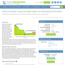
Part II involves transferring hydraulic head information from Microsoft Excel to a simplified sketch map of the quadrange and drawing contour lines on the potentiometric surface. Next, students use the contour lines to add arrows indicating the direction of groundwater flow. Finally, students apply their knowledge to determine which lakes could be affected by a toxic spill within the quadrangle.

In Part III, students study the results of dye tests in the Sulphur Springs quadrangle to analyze the flow of groundwater. They also use elevation data to construct a vertical cross section that illustrates the ground surface, the water table, and the potentiometric surface for the Floridan aquifer, and they relate the cross section to features on the topographic map.

(Note: this resource was added to OER Commons as part of a batch upload of over 2,200 records. If you notice an issue with the quality of the metadata, please let us know by using the 'report' button and we will flag it for consideration.)

Subject:
Biology
Hydrology
Life Science
Mathematics
Measurement and Data
Physical Science
Statistics and Probability
Material Type:
Activity/Lab
Provider:
Science Education Resource Center (SERC) at Carleton College
Provider Set:
Teach the Earth
Author:
Eileen Herrstrom
Date Added:
03/30/2022
A Guide to Rain Garden Construction
Read the Fine Print
Educational Use
Rating
0.0 stars

Students are presented with a guide to rain garden construction in an activity that culminates the unit and pulls together what they have learned and prepared in materials during the three previous associated activities. They learn about the four vertical zones that make up a typical rain garden with the purpose to cultivate natural infiltration of stormwater. Student groups create personal rain gardens planted with native species that can be installed on the school campus, within the surrounding community, or at students' homes to provide a green infrastructure and low-impact development technology solution for areas with poor drainage that often flood during storm events.

Subject:
Applied Science
Engineering
Hydrology
Physical Science
Material Type:
Activity/Lab
Provider:
TeachEngineering
Provider Set:
TeachEngineering
Author:
Brigith Soto
Jennifer Butler
Krysta Porteus
Maya Trotz
Ryan Locicero
William Zeman
Date Added:
09/18/2014