As Public Works Director of Nogales, Arizona, Alejandro Barcenas works to ensure …
As Public Works Director of Nogales, Arizona, Alejandro Barcenas works to ensure a safe and secure water supply for the city’s 20,500 residents. His task isn’t easy: the city is located in an arid region just north of the United States–Mexico border, and its entire supply comes from groundwater.
Half of Nogales’ water comes from alluvial aquifers that are highly responsive to rainfall events. Though this convenient source of water recharges easily, it is also vulnerable to climate-related changes such as reduced precipitation and increased evaporation. The other half of the city’s groundwater comes from a lower-quality source—this water is more expensive to produce. To optimize the use of the two sources of groundwater into the future, Barcenas is contributing to the development of a modeling tool that simulates how the aquifers may change in response to climate.
Objective: Students will conduct an experiment in order to determine how temperature …
Objective: Students will conduct an experiment in order to determine how temperature and salinity affect the density of water. This assignment will ask you to conduct a simple experiment to determine how temperature and salinity affect the density of water while filling out a worksheet.
In this activity for undergraduate students, learners build a highly simplified computer …
In this activity for undergraduate students, learners build a highly simplified computer model of thermohaline circulation in the North Atlantic Ocean and conduct a set of simulation experiments to understand the complex dynamics inherent in this simple model.
Methylmercury contamination within fish populations is an important toxin that affect human, …
Methylmercury contamination within fish populations is an important toxin that affect human, animal, and environmental health, serving as a carcinogen (cancer-causing agent) and endocrine-disruptor (compounds that in some way alter the signaling of the hormone system. The impacts of exceeding safe dietary methylmercury levels were tragically made clear in Ontario, Canada, where a First Nations community in Grassy Narrows are living with the consequences of methylmercury poisoning in the fish supply. The fish were contaminated due to the dumping of mercury in the traditional waterways of the First Nation community. In 2016, there were highly publicized protests in Muskrat Falls, Labrador, Canada, where the Inuit people raised direct concerns about the potential for a proposed Nalcor Energy hydroelectric dam, to increase mercury levels in fish in those waters, which are an integral part of their traditional diet. Despite significant protests, the project was completed in 2019 and 41 km were flooded. This module uses these real-world examples as a jumping-off point for exercises that will guide case-study driven discussion on mathematical, biological and ethical concerns.
A key first step toward developing students' understanding Woburn's water problems is …
A key first step toward developing students' understanding Woburn's water problems is having a students understand the geologic model of the Aberjona River Valley. Geologist use a series of tools to be able to construct models of the subsurface features of a given location. The first step in this tool is to look at these are official features of an area to gain a perspective of the subsurface composition. Geologist typically then will drill borings into the subsurface to obtain samples of rocks. During the drilling process geologist will measure the depth at which changes in rock type occur, they also will try to identify similar rock types and different borings to come up with a spatial arrangement of rock layers. This data is then used to construct the geologic cross-section. So the objective of this module is to get students familiar with its surface and subsurface geologic features so that they may begin to interpret the interrelation between geology and hydrogeology. Geologic logs are provided for students to create their own subsurface geologic cross-sections, which can be applied to later modules when they begin to evaluate groundwater flow towards Wells G & H.
(Note: this resource was added to OER Commons as part of a batch upload of over 2,200 records. If you notice an issue with the quality of the metadata, please let us know by using the 'report' button and we will flag it for consideration.)
In this module students learn some of the fundamental concepts of groundwater …
In this module students learn some of the fundamental concepts of groundwater flow including measurement of water levels, hydraulic heads, construction of potentiometric surfaces, delineation of flowpaths, and calculation of ground-water flow velocities and traveltimes. The goals of this module are to learn how to contour irregularly spaced data (water-level measurements made in observation wells), how to draw flowpaths on a contoured water-table map, how to measure hydraulic gradients from a contoured water-table map, and how to compute flow velocities and traveltimes using Darcy's law. The goals are applied to examining flowpaths of groundwater moving from the W.R. Grace and Beatrice properties and to computing traveltimes along these flowpaths.
(Note: this resource was added to OER Commons as part of a batch upload of over 2,200 records. If you notice an issue with the quality of the metadata, please let us know by using the 'report' button and we will flag it for consideration.)
This module uses existing publications from the USGS and the Army Corps …
This module uses existing publications from the USGS and the Army Corps of Engineers regarding flooding affects and classifications. The users are guided to basic overviews provided by those agencies can understand flooding and flooding concepts. The module also direct students to the 'real-time' data collected by the National Oceanic and Atmospheric Association in conjunction with the USGS so they can view graphs showing the relation between rainfall, river stage and flow for the Aberjona River. The NOAA and USGS databases can provide the user with real-time as well as historic data to track flood waves and establish base flows. This data was key to the trial in defining what amount of groundwater was derived from the Aberjona River.
(Note: this resource was added to OER Commons as part of a batch upload of over 2,200 records. If you notice an issue with the quality of the metadata, please let us know by using the 'report' button and we will flag it for consideration.)
Defining pumping of Wells G. and H was an important and contested …
Defining pumping of Wells G. and H was an important and contested issue during the trial. The induced infiltration module provides references regarding methods to measure induced infiltration and quantify surface water loss to groundwater from aquifer pumping. This module references different techniques for quantifying groundwater infiltration from streams. The purpose of this information is familiarizing users with the differing methods to quantify Stream loss due to induced infiltration so they can assess the effectiveness of the USGS data used during the trial.
(Note: this resource was added to OER Commons as part of a batch upload of over 2,200 records. If you notice an issue with the quality of the metadata, please let us know by using the 'report' button and we will flag it for consideration.)
Contaminant movement through the subsurface is different for each contaminant and for …
Contaminant movement through the subsurface is different for each contaminant and for different subsurface conditions. This module provides a general overview to the term "fate and transport," which refers to what happens when a contaminant migrates and its mode of migration. This module provides tools to help students understand the complexity of subsurface migration of contaminants and relate these complexities to trial issues. The module introduces concepts related to effective flow, dispersion, diffusion, and migration of partially soluble contaminants. Specific references to trichloroethylene (TCE) are provided as this was the most significant contaminant linking the defendants' to the plaintiffs' claims.
(Note: this resource was added to OER Commons as part of a batch upload of over 2,200 records. If you notice an issue with the quality of the metadata, please let us know by using the 'report' button and we will flag it for consideration.)
Students make Moebius strips and use them to demonstrate the interconnectedness of …
Students make Moebius strips and use them to demonstrate the interconnectedness of an environment. They explore the natural cycles water, oxygen/carbon dioxide, carbon, nitrogen that exist within the environment.
What determines the concentration of a solution? Learn about the relationships between …
What determines the concentration of a solution? Learn about the relationships between moles, liters, and molarity by adjusting the amount of solute and solution volume. Change solutes to compare different chemical compounds in water.
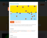
Add various unknown molecules to oil and water, and observe how the …
Add various unknown molecules to oil and water, and observe how the molecules sort themselves in response to interactions with the surrounding environment.
Students will design and conduct an experiment to see how temperature can …
Students will design and conduct an experiment to see how temperature can affect the particle motion of water. The students will test molecular motion in different temperatures of water by adding food coloring to the water and observing the motion of the water molecules. This investigation will allow the students to see the movement of food coloring in water and how an increase or decrease in temperature will affect that movement. This lesson results from a collaboration between the Alabama State Department of Education and ASTA.
Claude Monet, Les Nymphéas (The Water Lilies), suite of paintings on permanent …
Claude Monet, Les Nymphéas (The Water Lilies), suite of paintings on permanent exhibition at the Musée de l'Orangerie in Paris: Room 1: Morning, oil on two canvas panels, 200 x 425 cm, c. 1918-26 Clouds, oil on three canvas panels, 200 x 1275 cm, c. 1918-26 Green Highlights, oil on two canvas panels, 200 x 850 cm, c. 1918-26 Sunset, oil on canvas, 200 x 600 cm, c. 1918-26 Room 2: Reflection of Trees, oil on two canvas panels, 200 x 850 cm, c. 1918-26 The Morning Light, the willows, oil on three canvas panels, 200 x 1275 cm, c. 1918-26 The Morning Willows, oil on three canvas panels, 200 x 1275 cm, c. 1918-26 The Two Willows, oil on four canvas panels, 200 x 1700 cm, c. 1918-26 Speakers: Dr. Beth Harris and Dr. Steven Zucker. Created by Beth Harris and Steven Zucker.
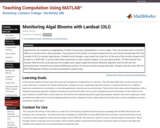
Algal blooms are caused by an aggregation of either microscopic phytoplankton or …
Algal blooms are caused by an aggregation of either microscopic phytoplankton or macro algae. They can produce toxic or harmful effects on humans and or the ecosystem. The purpose of this activity is to teach students how to use remote sensing data from the Landsat 8 (OLI) to monitor algal blooms. Students work through a case study from Lake Erie. At the end of this activity students will be able to, in MATLAB, 1) access USGS data repositories to view Landsat imagery, 2) access band specific .TIF files directly from Amazon Web Services, 3) pre-process the imagery and a apply single band bloom detection algorithm and 4) work with the atmospherically corrected Land Surface Reflectance product to improve remote sensing estimates. Students will also work with the MATLAB Mapping Toolbox to produce presentation quality maps.
(Note: this resource was added to OER Commons as part of a batch upload of over 2,200 records. If you notice an issue with the quality of the metadata, please let us know by using the 'report' button and we will flag it for consideration.)
Students will identify water sources in the school environment in order to …
Students will identify water sources in the school environment in order to understand the origins of our water and to gain perspective about the students' place in the water cycle. Students will learn about the water cycle using a variety of resources and discover connections between the water cycle and the water that they use every day.
This module is focused on increasing the users understanding and familiarity with …
This module is focused on increasing the users understanding and familiarity with the fate and transport of contaminants. Video clips of sand tank models showing the movement of contaminants in subsurface porous media are included. The sand tank models provide a visual guide to help see how different geologic materials with different permeability's effect the movement of fluids and ultimately the distribution of contaminants.
(Note: this resource was added to OER Commons as part of a batch upload of over 2,200 records. If you notice an issue with the quality of the metadata, please let us know by using the 'report' button and we will flag it for consideration.)
In a class demonstration, students observe a simple water cycle model to …
In a class demonstration, students observe a simple water cycle model to better understand its role in pollutant transport. This activity shows one way in which pollution is affected by the water cycle; it simulates a point source of pollution in a lake and the resulting environmental consequences.
No restrictions on your remixing, redistributing, or making derivative works. Give credit to the author, as required.
Your remixing, redistributing, or making derivatives works comes with some restrictions, including how it is shared.
Your redistributing comes with some restrictions. Do not remix or make derivative works.
Most restrictive license type. Prohibits most uses, sharing, and any changes.
Copyrighted materials, available under Fair Use and the TEACH Act for US-based educators, or other custom arrangements. Go to the resource provider to see their individual restrictions.


![Modified Grassy Narrows and Muskrat Falls Dam: Hypothesis Testing and t-Tests [version 2.0]](https://oercommons.org/static/newdesign/images/materials/default-thumbnail-index.png)