Updating search results...

Search Resources

1715 Results

View
Selected filters:
Crater Creations: Moon
Read the Fine Print
Rating
0.0 stars

This is an activity about impact craters. Learners will experiment to create impact craters and examine the associated features. Then they observe images of lunar craters and explore how the mass, shape, velocity, and angle of impactors affects the size and shape of the crater. This activity is part of Explore! To the Moon and Beyond! - a resource developed specifically for use in libraries.

Subject:
Physical Science
Space Science
Material Type:
Activity/Lab
Provider:
NASA
Provider Set:
NASA Wavelength
Date Added:
11/05/2014
Plate Tectonics: The Effects of Movement of the Earth on its Continental Plates
Unrestricted Use
CC BY
Rating
0.0 stars

Students preparing for the ACT, GED or other college prep equivalency exams or college entrance need to know the basics of science. Geology is one area that is included on most of these types of exams.  The study of continental drift forces involved and effect of the movement combine several science disciplines that will help students on those exams. In this unit, learners will illustrate, describe and demonstrate a basic knowledge of plate tectonics and the effect of shifts on seismic activity. This unit follows the WIPPEA model for lesson planning, and implements open-classroom strategies, where students will not only use OER but also modify and republish their content.

Subject:
Environmental Science
Material Type:
Activity/Lab
Assessment
Data Set
Lecture Notes
Reading
Author:
Leecy Wise
Don Dutton
Date Added:
12/27/2019
6.4 Plate Tectonics & Rock Cycling
Unrestricted Use
CC BY
Rating
0.0 stars

In this plate tectonics and rock cycling unit, students come to see that the Earth is much more active and alive than they have thought before. The unit launches with documentation of a 2015 Himalayan earthquake that shifted Mt. Everest suddenly to the southwest direction. Students read texts, explore earthquake and landform patterns using a data visualization tool, and study GPS data.

This unit is part of the OpenSciEd core instructional materials for middle school.

Subject:
Applied Science
Physical Science
Material Type:
Lesson
Lesson Plan
Unit of Study
Author:
OpenSciEd
Date Added:
02/11/2022
What are the Winds Blowing into Mammoth Cave?
Conditional Remix & Share Permitted
CC BY-NC-SA
Rating
0.0 stars

Spreadsheets Across the Curriculum/Geology of National Parks module. Students estimate the net volume of pollutants flowing into the Houchin's Narrows entrance of Mammoth Cave using actual air-flow and air-quality data from the park.

Subject:
Applied Science
Environmental Science
Geoscience
Physical Science
Material Type:
Activity/Lab
Provider:
Science Education Resource Center (SERC) at Carleton College
Provider Set:
Pedagogy in Action
Author:
Dorien K. McGee
Jonathan Jernigan
Date Added:
11/06/2014
Introduction to 3D Sketching
Conditional Remix & Share Permitted
CC BY-NC-SA
Rating
0.0 stars

This activity provides an introduction to 3D sketching. Students sketch a cube, boxes, and cylinders. They watch a video about how to sketch boxes and cylinders, and then sketch a few more.

Subject:
Geology
Physical Science
Material Type:
Homework/Assignment
Provider:
Science Education Resource Center (SERC) at Carleton College
Provider Set:
Teach the Earth
Author:
Tom Hickson
Date Added:
01/20/2023
Comparative Planetary Geomorphology
Conditional Remix & Share Permitted
CC BY-NC-SA
Rating
0.0 stars

Prior to this lab exercise, students discuss general physical differences between the planets Earth, Moon and Mars, and why these physical differences exist. They use globes and global data sets in lecture to investigate large-scale patters, similarities and differences between these bodies. They discuss methods by which planetary geologists study the surfaces of other planets. While working on this laboratory exercise, they use maps of the Earth, Moon and Mars (both geologic and topographic) as well as data from missions such as Clementine, MOLA, and HRSC, which they obtain online. The investigate impact crater morphology between the Earth and Moon; comparative planetary geology in the form of fluvial, tectonic, and volcanologic comparisons of Earth and Mars; and complete a geologic map and history of a region of Mars using only orbital images and data sets.

(Note: this resource was added to OER Commons as part of a batch upload of over 2,200 records. If you notice an issue with the quality of the metadata, please let us know by using the 'report' button and we will flag it for consideration.)

Subject:
Biology
Life Science
Mathematics
Measurement and Data
Physical Geography
Physical Science
Material Type:
Activity/Lab
Provider:
Science Education Resource Center (SERC) at Carleton College
Provider Set:
Teach the Earth
Author:
Jennifer Anderson
Date Added:
08/10/2019
Slicing Fruit
Conditional Remix & Share Permitted
CC BY-NC-SA
Rating
0.0 stars

Students identify and draw slices through fruit, as practice for drawing slices through more complex features.

Subject:
Geology
Physical Science
Material Type:
Activity/Lab
Homework/Assignment
Provider:
Science Education Resource Center (SERC) at Carleton College
Provider Set:
Teach the Earth
Author:
Tom Hickson
Date Added:
01/20/2023
Using Gesture to Support Spatial Thinking
Conditional Remix & Share Permitted
CC BY-NC-SA
Rating
0.0 stars

This activity highlights the value of gesture in communicating spatial information. It consists of two short exercises. In the first, students are asked to pair up and describe to their partner how to navigate from one place to another in their home town. In the second, a volunteer is asked to sit on his or her hands and describe how to tie a bow with a piece of ribbon. In the first exercise, students spontaneously gesture; in the second, the volunteer will very much want to gesture and may be unable to complete the task under the restriction given (sitting on hands).

Subject:
Geology
Physical Science
Material Type:
Activity/Lab
Provider:
Science Education Resource Center (SERC) at Carleton College
Provider Set:
Teach the Earth
Author:
Kristin Gagnier
Date Added:
01/20/2023
Mars Image Analysis
Read the Fine Print
Rating
0.0 stars

This is a lesson about using evidence to construct sequences of geologic events. Learners will interpret real NASA science data to identify features on the surface of Mars, determine the surface history of the area, calculate the size of features, and develope investigable questions. Students will study images taken by NASA's Mars Thermal Emission Imaging System (THEMIS) camera orbiting Mars. Students will use the THEMIS images to analyze the surface features and geological history of Mars. The lesson models scientific inquiry using the 5E instructional model and includes teacher notes and vocabulary.

Subject:
Geoscience
History
History, Law, Politics
Physical Science
Space Science
Material Type:
Activity/Lab
Assessment
Diagram/Illustration
Lesson Plan
Student Guide
Provider:
NASA
Provider Set:
NASA Wavelength
Date Added:
11/05/2014
What Does the Mean Mean? Describing Eruptions at Riverside Geyser, Yellowstone National Park
Conditional Remix & Share Permitted
CC BY-NC-SA
Rating
0.0 stars

Spreadsheets Across the Curriculum/Geology of National Parks module. Students study measures of central tendency in a bimodal dataset of eruption intervals.

Subject:
Geology
Geoscience
Physical Science
Material Type:
Activity/Lab
Provider:
Science Education Resource Center (SERC) at Carleton College
Provider Set:
Pedagogy in Action
Date Added:
11/06/2014
Erosion in Our World
Conditional Remix & Share Permitted
CC BY-NC-SA
Rating
0.0 stars

This activity is a field investigation where students observe evidence of erosion and deposition in the schoolyard or designated area.

Subject:
Geology
Physical Science
Material Type:
Activity/Lab
Provider:
Science Education Resource Center (SERC) at Carleton College
Provider Set:
Pedagogy in Action
Author:
Erin Leitner
Date Added:
08/16/2012
Introduction to Oceanography
Unrestricted Use
CC BY
Rating
0.0 stars

Introduction to Oceanography is a textbook appropriate to an introductory-level university course in oceanography. The book covers the fundamental geological, chemical, physical and biological processes in the ocean, with an emphasis on the North Atlantic region.

Subject:
Oceanography
Physical Science
Material Type:
Textbook
Provider:
Roger Williams University
Author:
Paul Webb
Date Added:
06/28/2019
Guided Discovery and Scoring Rubric for Petrographic Analysis of a Thin Section
Conditional Remix & Share Permitted
CC BY-NC-SA
Rating
0.0 stars

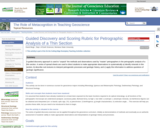
A series of spread sheets have been set up to provide a framework of observations and questions as a "guided discovery" exercise to clearly demonstrate the observations that a master petrographer would make. The observation of a thin section is broken down into a series of manageable tasks: reconnaissance overview of the thin section at low power; followed by creation of a systematic inventory of the rock-forming minerals (stable mineral paragenesis), alteration phases, and accessory minerals; and finally, analysis of the textures of igneous, sedimentary and metamorphic rocks.

Comprehensive lists of a) optical determinations, and b) textural features are provided as "cues" to the student to help focus attention on the full range of observations that could or should be made towards a comprehensive petrographic analysis of the thin section. These sheets are organized to include:

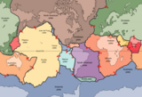
Consideration of the geologic context of the sample: What is the geologic setting where the rock was collected? What is the rock type (if known), or at least is it igneous, sedimentary or metamorphic? This type of contextual information will help guide you to interpret what minerals are likely to be present (or excluded) in the sample
Mineral Optics (identification of mineral phases in thin section.

Observations at low power in plane and cross polarized light.
Systematic characterization of the (stable) rock-forming minerals
Identification of a) secondary or replacement minerals, and b) important accessory minerals;

Description and Interpretation of Rock Textures

Igneous rocks
Clastic Sedimentary rocks
Non-clastic Sedimentary rocks (carbonates)
Metamorphic rocks

Applications; can these minerals/assemblages/textures be used to determine source area, physical conditions (thermobarometry), geo- or thermochronology, and other useful geologic information?

Initially, use of these spread sheets will appear to be prescriptive. However, given the complexity observed in Nature, no single set of questions can be universally applied to all types of samples. So, the steps and observations represented in these spread sheets provide a general framework--a place to start--and the lists of optical properties and textures are meant to be a reminder to students about the types of observations that should be made. Students can use these spread sheets as a guide to make decisions about what is important and useful for the overall interpretation.
Metacognitive components of the activity

Students derive an awareness of their own learning processes by considering "what" they are doing and "why" they are performing certain operations on the petrographic microscope.
Students monitor their own progress by considering a) what they expect to find based on geologic contexts, b) are their observations and interpretations consistent with what can (or cannot) occur in Nature, and
Adjust their learning strategies to accomodate new lines of evidence towards formulation of internally consistent (if not "correct") observations and interpretations of the thin section.

Metacognitive goals for this activity:
The first encounter with an unknown thin section can be both confusing and overwhelming: Where do I start? What should I look for? How should I proceed? How will I know if I'm doing the right thing, and making the right observations?....

The purpose of this exercise is to "unpack" the steps taken by a master petrographer, to describe "what" observations can be made, and explain "why" these steps should be taken, what the utility or significance of the observations is, and how these observations can be appropriately interpreted (often these observations are done instantaneously in the mind of the petrographer, but in this exercise we try to explicitly outline these steps). With practice and experience these steps will become second nature. The goal of this exercise is to help students master the art of petrography so that they can independently do petrographic analysis of any rock from any context.
Assessing students' metacognition
In the course of teaching petrography in my regular coursework, I find that I continually articulate to students (one at a time) what I am doing (and why), what I am seeing (and they may or may not be seeing the same thing), why certain relationships are to be expected or prohibited in Nature (by considering the larger geologic context). The development of these guided discovery activities is an attempt to clearly articulate to all students the steps that are routinely taken in the petrographic analysis of a thin section. The goal is to more efficiently and effectively get students past the "mechanical" stages of mineral identification and textural descriptions, and help them to begin to develop higher order thinking skills of application, analysis, synthesis, and evaluation.

(Note: this resource was added to OER Commons as part of a batch upload of over 2,200 records. If you notice an issue with the quality of the metadata, please let us know by using the 'report' button and we will flag it for consideration.)

Subject:
Biology
Geology
Life Science
Physical Science
Physics
Material Type:
Activity/Lab
Provider:
Science Education Resource Center (SERC) at Carleton College
Provider Set:
Teach the Earth
Author:
Dave Mogk
Date Added:
08/23/2020
A Traverse Through Time and Space: A Paleoenvironmental Analysis of Devonian Strata in New York State
Conditional Remix & Share Permitted
CC BY-NC-SA
Rating
0.0 stars

The purpose of this project is to develop students' field skills by starting at the outcrop scale and then building on these experiences to create a regional picture of events by visiting multiple sites across NY. Students become proficient and efficient at measuring stratigraphic sections in teams after 5 weeks of field work. We visit eight outcrops within 5 weeks and measure detailed stratigraphic sections at each site. We begin by learning how to measure a detailed ~6 m thick stratigraphic section of siliciclastic rocks exposed in a local state park (that students visited during their introductory physical geology course) using a Jacob staff and Brunton. The outcrop is comprised of only 3 lithologies, but many sedimentary structures (bioturbation, flute casts, drag marks, groove casts, asymmetric ripples (plan view) and trough cross-beds). These lithofacies repeat several times even within the ~6 m measured section as these are turbidite deposits. We return to the lab after measuring the section and students work up their field data to construct a detailed, hand-drawn stratigraphic section for the first time. Students also make paleocurrent measurements in the field when possible and learn to plot these pooled class data during the next class meeting. For the other local sections, students perform the same field observations and measurements. At these locales, several formations crop out and students learn to recognize them based on their lithologic and paleontologic composition. Both carbonate and siliciclastic rocks occur at these sites. During the 3-day weekend field trip, students measure three stratigraphic sections of Lower Devonian through Middle Devonian strata and recognize that, for example, western NY lacks the Helderberg carbonate sequence and that the Oriskany Sandstone is thicker and laterally continuous in eastern NY rather than the lenses that crop out in central-western NY. Students also realize that the Hamilton Group changes character as they march across NY, building on their reading of Walther's Law in Boggs (2006) and their in-class stratigraphic correlation (lithostratigraphy, biostratigraphy) exercises from Fichter and Poche (2001) completed prior to the weekend field trip.

(Note: this resource was added to OER Commons as part of a batch upload of over 2,200 records. If you notice an issue with the quality of the metadata, please let us know by using the 'report' button and we will flag it for consideration.)

Subject:
Biology
Career and Technical Education
Environmental Studies
Geology
Life Science
Physical Science
Material Type:
Activity/Lab
Provider:
Science Education Resource Center (SERC) at Carleton College
Provider Set:
Teach the Earth
Author:
Tara Curtin
Date Added:
08/08/2019
Something is Askew at Mammoth Cave National Park
Conditional Remix & Share Permitted
CC BY-NC-SA
Rating
0.0 stars

Spreadsheets Across the Curriculum/Geology of National Parks module. Students use the geometric mean and multiplicative standard deviation to examine the right-skewed distribution of nutrient concentrations in water-quality data at Mammoth Cave National Park.

Subject:
Applied Science
Environmental Science
Geoscience
Physical Science
Material Type:
Activity/Lab
Provider:
Science Education Resource Center (SERC) at Carleton College
Provider Set:
Pedagogy in Action
Author:
Amie O. West
Date Added:
11/06/2014
Petroleum Engineering
Conditional Remix & Share Permitted
CC BY-NC-SA
Rating
0.0 stars

The goal of this course is to obtain knowledge of the origins of petroleum and gas. An overview is given on the conditions that are needed for oil and gas to accumulate in reservoirs. Moreover, techniques to find and exploit these reservoirs are highlighted. The focus always is on the task of the petroleum geologist during the different phases of oil and gas exploration and production. After an introduction to the course including typical numbers and historical developments, essential terms and concepts like biomolecules and the carbon cycle are explained.

Subject:
Geology
Physical Science
Material Type:
Lecture
Lecture Notes
Reading
Provider:
Delft University of Technology
Provider Set:
TU Delft OpenCourseWare
Author:
S.M. Luthi
Date Added:
07/19/2011
Assessment of Potential Well Yield, Gallatin Regional Park MT
Conditional Remix & Share Permitted
CC BY-NC-SA
Rating
0.0 stars

This project helps familiarize students with data commonly available from well drillers, the Department of Natural Resources and Conservation, and the Montana Bureau of Mines and Geology. Such data is often used to produce consulting reports. In this exercise, students practice working with available data and writing a consulting report while working on a real project of local interest. The question involves the probability of success in drilling a large well for a new county park. Students are given various maps and are guided through the use of a statewide database that contains well logs and well data. The outcome is a written report that describes the location and general geology of the site, uses the available data to summarize the types of materials that a driller might encounter, answers the questions that the client is interested in, and identifies problems or advantages presented by the groundwater system as indicated by available data.

(Note: this resource was added to OER Commons as part of a batch upload of over 2,200 records. If you notice an issue with the quality of the metadata, please let us know by using the 'report' button and we will flag it for consideration.)

Subject:
Biology
Business and Communication
Hydrology
Life Science
Management
Physical Science
Political Science
Social Science
Material Type:
Homework/Assignment
Lesson Plan
Provider:
Science Education Resource Center (SERC) at Carleton College
Provider Set:
Teach the Earth
Author:
Stephan Custer
Date Added:
08/28/2019
Investigating Factors that Influence Weathering of Monuments in a Cemetery
Conditional Remix & Share Permitted
CC BY-NC-SA
Rating
0.0 stars

In this field activity students will discover some of the factors that influence weathering of rock by making observations, asking questions and completing an investigation of their own design in a local cemetery.

Subject:
Geology
Physical Science
Material Type:
Activity/Lab
Provider:
Science Education Resource Center (SERC) at Carleton College
Provider Set:
Pedagogy in Action
Author:
Ann Catlin Markegard
Date Added:
08/10/2012