DATA: North American Regional Reanalysis (NARR). TOOL: FieldScope GIS. SUMMARY: Use an …
DATA: North American Regional Reanalysis (NARR). TOOL: FieldScope GIS. SUMMARY: Use an online GIS from the National Geographic Society, to investigate the relationship between precipitation, evaporation, and surface runoff.
(Note: this resource was added to OER Commons as part of a batch upload of over 2,200 records. If you notice an issue with the quality of the metadata, please let us know by using the 'report' button and we will flag it for consideration.)
DATA: Ocean Buoy Data, MODIS Images TOOLS: GoMOOS Online Graphing Tool SUMMARY: Learn about conditions that influence the spring phytoplankton bloom. Use an online graphing tool to predict the date of the bloom.
(Note: this resource was added to OER Commons as part of a batch upload of over 2,200 records. If you notice an issue with the quality of the metadata, please let us know by using the 'report' button and we will flag it for consideration.)
Rapid changes at Earth's surface, largely in response to human activity, have …
Rapid changes at Earth's surface, largely in response to human activity, have led to the realization that fundamental questions remain to be answered regarding the natural functioning of the Critical Zone, the thin veneer at Earth's surface where the atmosphere, lithosphere, hydrosphere and biosphere interact. EARTH 530 will introduce you to the basics necessary for understanding Earth surface processes in the Critical Zone through an integration of various scientific disciplines. Those who successfully complete EARTH 530 will be able to apply their knowledge of fundamental concepts of Earth surface processes to understanding outstanding fundamental questions in Critical Zone science and how their lives are intimately linked to Critical Zone health.
This video segment adapted from NASA's Goddard Space Flight Center discusses how …
This video segment adapted from NASA's Goddard Space Flight Center discusses how a drought can have negative effects locally, for example by increasing the number of forest fires, and also globally, for example by impacting air quality thousands of miles away.
Our planet is becoming hot. In fact, Earth may be warming faster …
Our planet is becoming hot. In fact, Earth may be warming faster than ever before. This warming will challenge society throughout the 21st century. How do we cope with rising seas? How will we prepare for more intense hurricanes? How will we adapt to debilitating droughts and heat waves? Scientists are striving to improve predictions of how the environment will change and how it will impact humans. Earth in the Future: Predicting Climate Change and Its Impacts Over the Next Century is designed to provide the state of the art of climate science, the impact of warming on humans, as well as ways we can adapt. Every student will understand the challenges and opportunities of living in the 21st century.
This activity is a field trip investigation where students gather stream flow, …
This activity is a field trip investigation where students gather stream flow, volume, depth & height (area) data on Ramsey County dams (Keller and Round lake), interpret their findings and make in-depth observations in order to assess the effectiveness of dams through the season and estimate the life-span of the dams in years.
The goal of this exercise is to have students gain an understanding …
The goal of this exercise is to have students gain an understanding of how fractures affect groundwater flow patterns. In order for them to complete the activity, they need some background on characteristic fracture patterns in different rock types. This background could be provided in a variety of ways depending on geographic location and outcrop availability. If outcrops of crystalline and sedimentary sequences are available, you could take students in the field and have them observe (and perhaps sketch) the differing fracture patterns. If geology (and or weather) preclude this option, the students could observe fracture patterns from slides of outcrops (see slides in accompanying PowerPoint Presentation).
The classroom portion of the exercise uses a simple 2D numerical model (TopoDrive, available from USGS) to simulate flow in three aquifers: 1) homogeneous isotropic, 2) fractured crystalline, and 3) fractured sedimentary sequences. The task is to observe how the fracture patterns alter the flow patterns as compared to the homogeneous, isotropic simulation. The activity gives students practice in integrating geologic data into numerical models, describing flow patterns, and using computer technology. The activity also integrates knowledge from structural geology with hydrogeology.
(Note: this resource was added to OER Commons as part of a batch upload of over 2,200 records. If you notice an issue with the quality of the metadata, please let us know by using the 'report' button and we will flag it for consideration.)
This task, by ClimeTime educators, is for 4th grade students. After class …
This task, by ClimeTime educators, is for 4th grade students. After class discussions about how dams affect rivers, students analyze aerial photographs of the Elwha River taken just before and at intervals after the removal of the Elwha Dam. Students incorporate what they have learned about erosion to explain the phenomenon of change in the turbidity of the water and structure of the beach at the mouth of the river. Resource includes a student task document, teacher guide, and task facilitation slides.
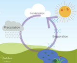
Students learn about the water cycle and hydrology through a series of …
Students learn about the water cycle and hydrology through a series of three lessons, two coloring book pages, and an e-Book. The themes covered in this resource tie into Climate Science and fundamental climate principles, as well as, engages students in scientific methods.
In this unit, students explore the various roles of environmental engineers, including: …
In this unit, students explore the various roles of environmental engineers, including: environmental cleanup, water quality, groundwater resources, surface water and groundwater flow, water contamination, waste disposal and air pollution. Specifically, students learn about the factors that affect water quality and the conditions that enable different animals and plants to survive in their environments. Next, students learn about groundwater and how environmental engineers study groundwater to predict the distribution of surface pollution. Students also learn how water flows through the ground, what an aquifer is and what soil properties are used to predict groundwater flow. Additionally, students discover that the water they drink everyday comes from many different sources, including surface water and groundwater. They investigate possible scenarios of drinking water contamination and how contaminants can negatively affect the organisms that come in contact with them. Students learn about the three most common methods of waste disposal and how environmental engineers continue to develop technologies to dispose of trash. Lastly, students learn what causes air pollution and how to investigate the different pollutants that exist, such as toxic gases and particulate matter. Also, they investigate the technologies developed by engineers to reduce air pollution.
This class is one of the core requirements for the Environmental Masters …
This class is one of the core requirements for the Environmental Masters of Engineering program. It is designed to teach about environmental engineering through the use of case studies, computer software tools, and seminars from industrial experts. Case studies provide the basis for group projects as well as individual theses. Past case studies have included the MMR Superfund site on Cape Cod; restoration of the Florida Everglades; dredging of Boston Harbor; local watershed trading programs; appropriate wastewater treatment technology for Brazil; point-of-use water treatment for Nepal, Brownfields Development in Providence, RI, and water resource planning for the island of Cyprus. This class spans the entire academic year: students must register for the Fall term, IAP, and the Spring term.
This class is one of the core requirements for the Environmental Masters …
This class is one of the core requirements for the Environmental Masters of Engineering program, in conjunction with 1.133 Masters of Engineering Concepts of Engineering Practice. It is designed to teach about environmental engineering through the use of case studies, computer software tools, and seminars from industrial experts. Case studies provide the basis for group projects as well as individual theses. Recent 1.782 projects include the MMR Superfund site on Cape Cod, appropriate wastewater treatment technology for Brazil and Honduras, point-of-use water treatment and safe storage procedures for Nepal and Ghana, Brownfields Development in Providence, RI, and water resource planning for the island of Cyprus and refugee settlements in Thailand. This class spans the entire academic year; students must register for the Fall and Spring terms.
This is a inquiry-driven class research project on a local environmental geochemistry …
This is a inquiry-driven class research project on a local environmental geochemistry question that is accomplished during three-hour laboratory sessions each week. Students are divided into groups that will share the responsibilities of collecting samples and data. Once the data is collected, it is shared among the entire class so that all students have the same data set. The class works on data presentation, preliminary analysis, and statistics together Then each student writes his/her own report separately.
Outcomes:
Laboratory skills -- Students have basic laboratory skills necessary to carry out a supervised geochemical study (e.g. can perform Gram titration of waters in field, can collect water samples using clean methods).
Quantitative methods -- Students can manipulate, sort, and transfer data in Excel and can create simple x-y plots and histograms to bring out trends in data.
Critical thinking -- Students can develop multiple hypotheses to explain trends in data and can design tests of these hypotheses.
(Note: this resource was added to OER Commons as part of a batch upload of over 2,200 records. If you notice an issue with the quality of the metadata, please let us know by using the 'report' button and we will flag it for consideration.)
This is an independent case study project completed in pairs. The students …
This is an independent case study project completed in pairs. The students should investigate an example of natural geochemistry and then use a poster format to share their findings with the class.
(Note: this resource was added to OER Commons as part of a batch upload of over 2,200 records. If you notice an issue with the quality of the metadata, please let us know by using the 'report' button and we will flag it for consideration.)
Students collect data for this term project starting with the first lab …
Students collect data for this term project starting with the first lab exercise and continuing throughout the semester. As each unit is covered in the text, class, and lab, students are directed to collect data relevant to their term project. For example: Topographic maps are covered at the start of the semester and students must locate their home; describe its location using the Public Land Survey, Universal Transverse Mercator, and Longitude-Latitude Systems; and describe the local topography. When natural hazards (flooding, slopes, earthquakes, volcanoes, and radon gas) are covered, students must use web resources (some of which are provided by the instructor at http://www2.ivcc.edu/phillips/geology/environmental_research.htm), local resources (such as the local fire chief, library, mayor, relatives, and neighbors), and personal observation to identify hazards and assess the risk they pose; these hazards are submitted as part of a lab assignment. The information collected is analyzed using the principles discussed in class and feedback is provided on pieces that are submitted throughout the semester. At the conclusion of the semester, students organize the collected information, add illustrations (maps and photos), analyze and evaluate the materials collected, and conclude the report with a discussion of how the area should be developed in the future based on the principles learned in the class.
The activity shows the students the immediate relevance of the material as it is covered, shows the students the types of information publicly available, and helps them develop critical analysis skills. The activity introducers students to basic geologic knowledge and shows them how to make use of it.
(Note: this resource was added to OER Commons as part of a batch upload of over 2,200 records. If you notice an issue with the quality of the metadata, please let us know by using the 'report' button and we will flag it for consideration.)
The Environment and the Earth class at the University of South Carolina …
The Environment and the Earth class at the University of South Carolina participated in a campus environmental service-learning project where students collected data lighting, water fixtures, recycling bins, and trash in five academic buildings.
(Note: this resource was added to OER Commons as part of a batch upload of over 2,200 records. If you notice an issue with the quality of the metadata, please let us know by using the 'report' button and we will flag it for consideration.)
Compiled by Suzanne Savanick, Science Education Resource Center. Based on Bixby et al. (2003), Ecology on Campus: Service Learning in Introductory Environmental Courses, Journal of College Science Teaching, v. 32, n.5, o, 327-331.
A great variety of processes affect the surface of the Earth. Topics …
A great variety of processes affect the surface of the Earth. Topics to be covered are production and movement of surficial materials; soils and soil erosion; precipitation; streams and lakes; groundwater flow; glaciers and their deposits. The course combines aspects of geology, climatology, hydrology, and soil science to present a coherent introduction to the surface of the Earth, with emphasis on both fundamental concepts and practical applications, as a basis for understanding and intelligent management of the Earth's physical and chemical environment.
No restrictions on your remixing, redistributing, or making derivative works. Give credit to the author, as required.
Your remixing, redistributing, or making derivatives works comes with some restrictions, including how it is shared.
Your redistributing comes with some restrictions. Do not remix or make derivative works.
Most restrictive license type. Prohibits most uses, sharing, and any changes.
Copyrighted materials, available under Fair Use and the TEACH Act for US-based educators, or other custom arrangements. Go to the resource provider to see their individual restrictions.