This is an engineering laboratory subject for mechanical engineering juniors and seniors. …
This is an engineering laboratory subject for mechanical engineering juniors and seniors. Major emphasis is on interplay between analytical and experimental methods in solution of research and development problems. Communication (written and oral) of results is also a strong component of the course. Groups of two or three students work together on three projects during the term.
The world has become more complicated with the introduction and development of …
The world has become more complicated with the introduction and development of new technologies and methods, and novel risks such as Covid-19 pandemic. Competition has been tougher than it used to be. Organizations strive to keep up with the changes in the internal and external environment. In the light of unprecedented changes, project managers must be prepared in response to the demands from their organizations and key stakeholders like clients, customers and government agencies. This book covers the fundamentals of project management, and aims to guide undergraduate and graduate students to acquire the building blocks of project management. This book also includes Microsoft Project tutorials for project scope, schedule, resources, and cost, and monitoring and controlling.
Water conservation teams will perform a school water audit to determine how …
Water conservation teams will perform a school water audit to determine how much water the school uses (indoors and outdoors), what activities and behaviors contribute to water loss and waste, and what changes could be enacted to conserve water at their school.
In this service learning project, students will collaborate in teams and with community partners to:
Collect data from existing sources such as past water bills, campus census data, and school facility maps Measure school water use (indoors/outdoor) and make "field" observations by performing the 7-Step School Water Audit Analyze data, formulate problem statements, and make recommendations for action plans to improve water efficiency Create an extended abstract or poster for the project Present the project to an authentic audience of students, teachers, school administrators, water supply entities and other community partners Make real-world changes to conserve water
In week one of the exercise students determine stream discharge by doing …
In week one of the exercise students determine stream discharge by doing some tedious, but simple hand calculations using data sets provided by the instructor. The following week is designed to be more hands-on. Here, they collect their own field data and create a spreadsheet to perform the calculations more efficiently and accurately. By collecting the data themselves, students gain a more thorough understanding of how stream discharge is both measured and computed; they also learn how the results can be used to determine groundwater baseflow. The fact they do hand calculations prior to creating the spreadsheet helps build their math skills and reduces the "black-box" effect that often develops when using software for data analysis. Students also gain valuable experience creating spreadsheets and learn how this tool can be used to perform repetitive computations more efficiently and with less error. Finally, this exercise asks students to consider the accuracy of their replicate field measurements through a series of questions related to their standard deviation and percent error calculations.
(Note: this resource was added to OER Commons as part of a batch upload of over 2,200 records. If you notice an issue with the quality of the metadata, please let us know by using the 'report' button and we will flag it for consideration.)
In this service learning project, students, teachers and community members will work …
In this service learning project, students, teachers and community members will work together to design and construct a rainwater harvesting system for their school campus.
Research RWH design basics and local conditions Explore how RWH could be used on your campus and develop a basic design. Present findings and action plan to community partners, school administration and student body. Enact the action plan to construct a RWH system on your campus and raise community awareness for water conservation
(Note: this resource was added to OER Commons as part of a batch upload of over 2,200 records. If you notice an issue with the quality of the metadata, please let us know by using the 'report' button and we will flag it for consideration.)
The wastewater treatment plant in Hamilton, Ontario is unable to keep up …
The wastewater treatment plant in Hamilton, Ontario is unable to keep up with demand during heavy rainstorms. Combined sewage and stormwater lines in the oldest parts of the city trigger outflow of screened sewage directly into the harbour several times each year, after heavy rains. The harbour itself has been the focus of a remediation effort for several decades. Addressing both industrial legacy pollution and the municipal sewage problem is considered to be key to achieving the harbour's "delisting" as an area of concern in the Great Lake watershed. This project requires students to help Hamilton residents reduce the pressure on the wastewater treatment plant by reducing the amount of water in the sewage system, the amount of water in the stormwater system or by ensuring that the water is relatively free of chemicals pollution. Some pharmaceuticals have been linked to a feminizing effect on the native fish in the harbour (Purdy, 2009). Students develop realistic strategies for residents to adopt and present their findings to a community partner, the Bay Area Restoration Council, involved with the remediation effort. Students arrange themselves into groups of three or four during a regular lecture. Any students not present at that lecture will be assigned to a group by the instructor. The groups are then charged with writing and signing a contract detailing the responsibilities and consequences of the work. For example, groups may decide how many meetings may be missed and what happens if a member misses too many meetings. Typically, the most stringent consequence is that a member is removed from the group and must complete the assignment, on time, independently. There was one case of this last year.
The groups then sign up to conduct research into one of four different theme areas: grey water, stormwater, water waste in bathrooms and domestic chemicals. They then develop a strategy for an average household to reduce pressure on the wastewater treatment plant in one of these areas. The strategy must be economically feasible for most residents in the city. The groups meet with myself or a teaching assistant at least once during the project to talk about their plan. The physical posters and electronic versions are all due on the same day and are then displayed in two separate "poster days." Students are given participation marks for giving feedback on notepads hung at each poster. Community partners form a panel of guest judges and talk to the students about their work, ask questions etc. The teaching assistants and I also visit each poster and ask questions. The guest judges award prizes to the best poster in each category (independent of any marks). Last year, the best ten posters (judged by the guests and the instructors) were also invited to present their posters at the annual general meeting of the community partner. Members of the public circulated among the posters and talked to students about their work. Members of the press were also present. This annual meeting took place after the semester had ended. The plan for the next version of this project is to send the electronic files out to community partners so they can display them on their web pages or print them out and display them in offices, schools or other public places.
(Note: this resource was added to OER Commons as part of a batch upload of over 2,200 records. If you notice an issue with the quality of the metadata, please let us know by using the 'report' button and we will flag it for consideration.)
One of the goals of my Mineralogy class is to demonstrate how …
One of the goals of my Mineralogy class is to demonstrate how the principles and content covered in class can be applied to questions of geologic interest or that have practical applications to society or industry. This is an early step towards introducing students to authentic research projects. The general theme of these projects is characterization of Earth materials, and typically involves collection of samples in the field (if possible), hand sample observation, petrographic analysis, and further analysis using X-ray powder diffraction and electron beam techniques such as scanning electron microscopy (SEM) and back-scattered electron (BSE) imaging and elemental analysis using energy dispersive spectroscopy (EDS).
(Note: this resource was added to OER Commons as part of a batch upload of over 2,200 records. If you notice an issue with the quality of the metadata, please let us know by using the 'report' button and we will flag it for consideration.)
Detailed information is provided in activity description/assignment and an example lab handout …
Detailed information is provided in activity description/assignment and an example lab handout that assisted students in conducting their research.
Initial guidelines given to students:
Choose a location (where you are from, a place that is of interest to you) and investigate how projected changes in climate will affect that area. What are the expected changes in temperature, precipitation, storms, droughts, sea level, seasonality, etc? How will this affect the habitat of the area (for humans, animals, and plants)? How will this affect the local economy? What actions can the people that live in this area take to lessen the impacts of changing climate? Students write a scientific style paper on their findings, and present their research to the class in ~10 minute oral presentations (alternatively a poster session could be used).
(Note: this resource was added to OER Commons as part of a batch upload of over 2,200 records. If you notice an issue with the quality of the metadata, please let us know by using the 'report' button and we will flag it for consideration.)
In this field exercise for an introductory environmental science course, students investigate …
In this field exercise for an introductory environmental science course, students investigate plant cover and type in a riparian area using transects. The final assignment is a lab report that includes a summary data table, a graph of cover types along their transect and an analysis of riparian health.
(Note: this resource was added to OER Commons as part of a batch upload of over 2,200 records. If you notice an issue with the quality of the metadata, please let us know by using the 'report' button and we will flag it for consideration.)
Students pose a question that can be answered using the SEM and …
Students pose a question that can be answered using the SEM and sand they have previously collected from beach profiles.
(Note: this resource was added to OER Commons as part of a batch upload of over 2,200 records. If you notice an issue with the quality of the metadata, please let us know by using the 'report' button and we will flag it for consideration.)
These project materials scaffold students through a semester-long, original research project. This …
These project materials scaffold students through a semester-long, original research project. This specific project was developed using the online planetary science database JMARS. Weekly assignments guide introductory students through developing, researching, and presenting original research.
(Note: this resource was added to OER Commons as part of a batch upload of over 2,200 records. If you notice an issue with the quality of the metadata, please let us know by using the 'report' button and we will flag it for consideration.)
This project is designed to introduce students to a local hydrogeologic problem …
This project is designed to introduce students to a local hydrogeologic problem or issue of interest to the community. The project requires the students to learn about their local groundwater environment and apply principles and concepts that they learn in the classroom to an issue that is of concern to the public. This project provides a good introduction to "real world" problems that the students are likely to encounter as professionals. Students are required to synthesize information from a variety of sources and develop their own assessment of the problem and also to make recommendations based on their professional opinions.
(Note: this resource was added to OER Commons as part of a batch upload of over 2,200 records. If you notice an issue with the quality of the metadata, please let us know by using the 'report' button and we will flag it for consideration.)
Service-Learning is a means of exploring sustainability and connecting experiential learning with …
Service-Learning is a means of exploring sustainability and connecting experiential learning with academic study of the topic.
(Note: this resource was added to OER Commons as part of a batch upload of over 2,200 records. If you notice an issue with the quality of the metadata, please let us know by using the 'report' button and we will flag it for consideration.)
A semester-long audio recording project, defined by the needs of a community …
A semester-long audio recording project, defined by the needs of a community organization, engages students in not only learning new content but sharing their new knowledge beyond classroom walls (and beyond the professor). This assignment, focusing on "engaged digital scholarship," challenges students to increase their information literacy and use of audio to effectively communicate scientific information for a general audience. This project has been embedded in several different introductory-level Earth science courses for non-science majors, with the resulting podcasts being shared with varied community groups. The example presented here focuses on students in a "Water: Science and Society" course generating podcasts that respond to specific content questions posed by Pennsylvania K-12 teachers, with the resulting podcasts posted on the website for the Pennsylvania Earth Science Teachers Association (PAESTA).
(Note: this resource was added to OER Commons as part of a batch upload of over 2,200 records. If you notice an issue with the quality of the metadata, please let us know by using the 'report' button and we will flag it for consideration.)
Student-designed, data-based authentic research projects can be useful tools for incorporating a …
Student-designed, data-based authentic research projects can be useful tools for incorporating a dimension of authentic research in non-major science courses. Such an approach has been followed in a geoscience course for non-majors at UW Whitewater. Students worked in pairs and selected a research topic on a local environmental issue, wrote a research proposal, collected, analyzed and synthesized data, and presented their research in a public poster presentation session. They critiqued their peers' proposals and posters, and assessed their own learning. Student self-assessment reports indicated that they found such projects to be personally enriching. Students reported significant learning gains from participating in this project. Such an approach can be applicable in a variety of courses for promoting student engagement in science classrooms.
(Note: this resource was added to OER Commons as part of a batch upload of over 2,200 records. If you notice an issue with the quality of the metadata, please let us know by using the 'report' button and we will flag it for consideration.)
Project Description (Microsoft Word 14kB Jan26 10) Water collection and usage in …
Project Description (Microsoft Word 14kB Jan26 10) Water collection and usage in the Sustainable SW Japanese Garden
The Albuquerque Water Authority has several activities on their web site to help with making a personal water audit, selecting xeriscape plants, designing garden areas as well as forms for rebates. We used the ABQ Water Authority design format to calculate which plants to install. Students start with a personal water audit and then move to the design of the garden. Personal water audit http://www.abcwua.org/Understanding_Your_Bill.aspx Techniques to consevere water outdoors http://www.abcwua.org/Save_Water_Outdoors.aspx Planning Xeriscape - students create their own personal garden and we transfer the concepts to the Japanese Garden. We are looking at Japanese design elements with a SW flare and thereby modeling what the internees did when they were limited to the surrounding rock, vegetation and water collection. http://www.abcwua.org/Xeriscaping.aspx
Calculating roof area using a Google satellite image
We use a measurable square on the pathway for the scale and then we calculate the square feet of the roof area. A transparency is used to overlay the image and calculate the water harvest.
Calculating the capacity of the 1500 gallon cistern in terms of water needed per plant
Students experiment with buckets to see ascertain the best collection site. The water is measured after rainfalls and compared to the weather data collected by the NOAA.
(Note: this resource was added to OER Commons as part of a batch upload of over 2,200 records. If you notice an issue with the quality of the metadata, please let us know by using the 'report' button and we will flag it for consideration.)
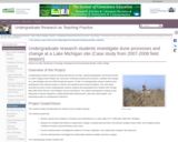
Undergraduate research students working with Deanna van Dijk, a physical geographer and …
Undergraduate research students working with Deanna van Dijk, a physical geographer and faculty member at Calvin College (Grand Rapids, MI), have been monitoring coastal dune processes, variables and changes at a Lake Michigan site from 2000 through the present. To date, 14 undergraduate research students have participated in this research project in summer and academic-year research positions. This case study describes the work of three undergraduate research students who participated from October 2007 through May 2008: Brent Geurink, Luke Pettinga, and Jon Schmitkons. The students participated in setting up and taking down research equipment, making weekly field measurements, data entry, data analysis, and presenting results at a professional conference.
(Note: this resource was added to OER Commons as part of a batch upload of over 2,200 records. If you notice an issue with the quality of the metadata, please let us know by using the 'report' button and we will flag it for consideration.)
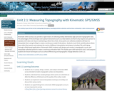
Kinematic GNSS surveys can provide a rapid means of collecting widely distributed, …
Kinematic GNSS surveys can provide a rapid means of collecting widely distributed, high-precision topographic data. The advantages of this technique over optical instruments such as a total station are that it only requires one person to operate and it does not rely on maintaining a direct line of site. Once points are collected, students will learn to interpolate them using ArcMap to create a continuous model of elevations. Students must think carefully about where they collect their points and evaluate the merits of different interpolation techniques including TIN and Kriging. Through a field-based application of kinematic GNSS, students will design and conduct a topographic survey and interpolate collected points to create a continuous elevation field. This builds upon skills learned in Unit 2 and prepares students for future techniques such as surface differencing and topographic change detection (Unit 2.2).
Show more information on GPS versus GNSS Hide Note: Although the term GPS (Global Positioning System) is more commonly used in everyday language, it officially refers only to the USA's constellation of satellites. GNSS (Global Navigation Satellite System) is a universal term that refers to all satellite navigation systems including those from the USA (GPS), Russia (GLONASS), European Union (Galileo), China (BeiDou), and others. In this module, we use the term GNSS to refer generically to the use of one or more satellite constellations to determine position.
(Note: this resource was added to OER Commons as part of a batch upload of over 2,200 records. If you notice an issue with the quality of the metadata, please let us know by using the 'report' button and we will flag it for consideration.)
Students will collect and analyze relevant social data on individual and community …
Students will collect and analyze relevant social data on individual and community knowledge, risk perception and preparedness within their local social networks.
(Note: this resource was added to OER Commons as part of a batch upload of over 2,200 records. If you notice an issue with the quality of the metadata, please let us know by using the 'report' button and we will flag it for consideration.)
The example of a proposed land-use change that was used in Unit …
The example of a proposed land-use change that was used in Unit 2.3 is built upon here. The activities in this unit are meant to broaden the discussion beyond calculating quantitative run-off changes. Now we will also bring in consideration of a broader range of ecosystem services, as well as other ways in which a landscape can be valued, some of which may not be easily measured or even conceptualized as "services." Classroom time is devoted to the instructor and students exploring both (a) the stakeholders who have an interest in a particular place and (b) the various interests/uses those stakeholders may have for that place. By the end of the activity, the class should have identified several major stakeholder groups and several distinct ecosystem services. Students, organized into groups representing particular stakeholders, will then be tasked to prepare, for Unit 3.2, a group presentation, to be discussed on class on the last day of the module, that utilizes those ecosystem services as much as possible.
(Note: this resource was added to OER Commons as part of a batch upload of over 2,200 records. If you notice an issue with the quality of the metadata, please let us know by using the 'report' button and we will flag it for consideration.)
No restrictions on your remixing, redistributing, or making derivative works. Give credit to the author, as required.
Your remixing, redistributing, or making derivatives works comes with some restrictions, including how it is shared.
Your redistributing comes with some restrictions. Do not remix or make derivative works.
Most restrictive license type. Prohibits most uses, sharing, and any changes.
Copyrighted materials, available under Fair Use and the TEACH Act for US-based educators, or other custom arrangements. Go to the resource provider to see their individual restrictions.