This video is provided by Wisconsin Fast Plants and demonstrates how to …
This video is provided by Wisconsin Fast Plants and demonstrates how to plant Fast Plants seeds using the Deli Container Growing System. The video gives an overview of the materials necessary to grow plants with this method, and also provides step-by-step instructions guiding the process. This recording runs for 02:47 minutes in length. Additional videos about planting with Fast Plants are available to view separately.
This video is provided by Wisconsin Fast Plants, and demonstrates how to …
This video is provided by Wisconsin Fast Plants, and demonstrates how to plant Fast Plant seeds using a quad-planter and wicking reservoir system. The video gives an overview of the materials necessary to grow plants with this method, and also provides step-by-step instructions guiding the process. The use of quads in this growing method is teacher-friendly, and enables collaboration between students. This recording runs for 03:07 minutes in length. Additional videos about planting with Fast Plants are available to view separately.
In this Biodiversity Counts activity, students learn how to replicate an arthropod's …
In this Biodiversity Counts activity, students learn how to replicate an arthropod's natural habitat in order to create suitable guest quarters. The online page includes instructions for what to observe in an arthropod's environment, tips for converting a container, such as a soda bottle or aquarium, into a hospitable habitat with plenty of oxygen, water, hiding places, and other arthropod necessities, notes about what to feed the arthropod and where to purchase both arthropods and their food.
Geography 430 is an active, creative learning community focused around understanding the …
Geography 430 is an active, creative learning community focused around understanding the changing relationships between people and their environments, the causes and consequences of environmental degradation, strategies for building a more sustainable world, and the methods and approaches that scholars have used to understand human-environment interactions. The primary course objectives are to help geographers, earth scientists, and other professionals to deepen their appreciation for the complexity of human-environment systems and to develop skills that allow them to interpret, analyze, and communicate effectively regarding human-environment interactions in their lives as students, professionals, and citizens.
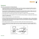
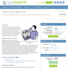
Students learn about the human water cycle, or how humans impact the …
Students learn about the human water cycle, or how humans impact the water cycle by settling down in civilizations. Specifically, they learn how people obtain, use and dispose of water. Students also learn about shortages of treated, clean and safe water and learn about ways that engineers address this issue through water conservation and graywater recycling.
This lab gives students a bare-bones introduction to one GIS software package, …
This lab gives students a bare-bones introduction to one GIS software package, ArcMap. I hope that students will get comfortable with how GIS programs layer data, and that they will begin to appreciate the power of GIS for solving a wide variety of problems. Students access freely available shape files, and make a map of Lake Mead, the largest human-made reservoir in the United States. (It formed behind the Hoover Dam when that was constructed on the Colorado River in the 1930s.) Then, they compare the mass of water lost to evaporation from the surface of Lake Mead to the evaporation that was occurring from the surface of the pre-dam river. Finally, they make a map of some other location affected by human activities. This activity could easily be expanded to have students calculate the amount of sediment that has been trapped behind Lake Mead, because sediment depths are also available online. Designed for a geomorphology course Uses online and/or real-time data
(Note: this resource was added to OER Commons as part of a batch upload of over 2,200 records. If you notice an issue with the quality of the metadata, please let us know by using the 'report' button and we will flag it for consideration.)
This article examines the sixth of seven essential principles of the climate …
This article examines the sixth of seven essential principles of the climate sciences--"We Change Earth's Climate." Written for the science teacher, the article covers greenhouse gases, land-use changes, and other human-induced causes of global climate change. Each issue of the free online magazine Beyond Weather and the Water Cycle is structured around one of the seven principles. The content provides background information, lessons, and activities for K-5 classrooms.
Using thermometers, cotton balls, string and water, students make simple psychrometers—a tool …
Using thermometers, cotton balls, string and water, students make simple psychrometers—a tool that measures humidity. They learn the difference between relative humidity (the ratio of water vapor content to water vapor carrying capacity) and dew point (the temperature at which dew forms). Teams collect data using their homemade psychrometers and then calculate relative humidity inside and outside, comparing their results to an off-the-shelf psychrometer (if available). A lab worksheet is provided for data collection and calculation. As a real-world connection, students learn that humidity and air density is taken into consideration by engineers for many design projects. To conclude, they answer and discuss analysis and application questions.
In this video segment adapted from the National Film Board of Canada, …
In this video segment adapted from the National Film Board of Canada, learn how the Inuit people have used their traditional knowledge to understand and adapt to changes in their Arctic environment, particularly when hunting and navigating the landscape.
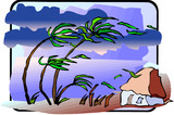
Learning ObjectivesFlorida is situated in what is known as the "hurricane alley." …
Learning ObjectivesFlorida is situated in what is known as the "hurricane alley." This region starts from the west coast of Africa to Florida, and up the Carolinas. This region is prone to tropical storms and hurricanes due to the warm water temperatures. The objective of this lesson is to offer tips and strategies without causing fear to elementary-level students so that students they can be prepared for the event of a hurricane ahead of time.
This transcribed article from American Radio Works discusses the hurricane risk in …
This transcribed article from American Radio Works discusses the hurricane risk in New Orleans. The 2002 article talks about how deep flood waters would be in a Category Five hurricane and the likelihood that such a storm would hit. Users may also listen to the article using Real Player audio program.
Students learn what causes hurricanes and what engineers do to help protect …
Students learn what causes hurricanes and what engineers do to help protect people from destruction caused by hurricane winds and rain. Research and data collection vessels allow for scientists and engineers to model and predict weather patterns and provide forecasts and storm warnings to the public. Engineers are also involved in the design and building of flood-prevention systems, such as levees and floodwalls. During the 2005 hurricane season, levees failed in the greater New Orleans area, contributing to the vast flooding and destruction of the historic city. In the associated activity, students learn how levees work, and they build their own levees and put them to the test!
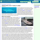
Last month, biologists announced the discovery of hybrid sharks in Australian waters. …
Last month, biologists announced the discovery of hybrid sharks in Australian waters. The new sharks may not warrant a marine park attraction they look much like their closely-related parent species but do represent an unexpected twist of biology and evolution. This is the first time that scientists have found evidence of shark hybridization an event that was thought to be rare because, unlike the many fish that simply release eggs and sperm into the water, sharks mate. Clearly, though, the widely-distributed common blacktip shark and the Australian blacktip shark (which is restricted to northern and eastern Australia) have few qualms about each other: 57 apparently healthy hybrid individuals were discovered in the first investigation of these animals. What does this mean for the future evolution of blacktip sharks?
In this three lesson series, students will analyze the effects of the …
In this three lesson series, students will analyze the effects of the drought in California. Students will analyze rainfall data and graph the annual rainfall for California. Students will understand the water cycle and explain how a drought affects the water cycle. Students will research methods to conserve water and write a persuasive argument.
This activity provides the hydrogeology students an exercise to understand specific discharge, …
This activity provides the hydrogeology students an exercise to understand specific discharge, hydraulic conductivity, and porous media. They will actually use a Darcy column to gather data on porous media, as well as calculate and understand the hydrologic properties of the materials.
(Note: this resource was added to OER Commons as part of a batch upload of over 2,200 records. If you notice an issue with the quality of the metadata, please let us know by using the 'report' button and we will flag it for consideration.)
In this field exercise, students measure channel cross sections in a rough …
In this field exercise, students measure channel cross sections in a rough alluvial and smooth bedrock-floored reach in a local stream. This exercise is hypothesis-driven. The hypothesis states that increasing roughness decreases average stream velocity, and so the depth and/or width must increase for the rougher bed. Working in groups, students use hand levels, tape measures, and surveying rods to document channel geometry. They then must reduce the data and plot it as distance-elevation on a chart. Finally, they analyze and compare the results to the predicted roughness-hydraulic geometry relation. Students learn simple surveying methods to collect field data. Students compare real world data to theoretical predictions. Students gain insight into how bank and bed roughness influences water flow, and thus can also influence flood heights. Designed for a geomorphology course Integrates geomorphology into a core course in geology Designed for an introductory geology course Uses geomorphology to solve problems in other fields
(Note: this resource was added to OER Commons as part of a batch upload of over 2,200 records. If you notice an issue with the quality of the metadata, please let us know by using the 'report' button and we will flag it for consideration.)
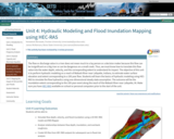
The flow or discharge value in a river does not mean much …
The flow or discharge value in a river does not mean much to a lay person or a decision maker because this flow can be insignificant on a big river or can be dangerous on a small creek. Thus, we must know how to translate this flow value into the water depth, velocity, and the corresponding extent to understand its impact. The objective of this unit is to perform hydraulic modeling on a reach of Wabash River near Lafayette, Indiana, to estimate water surface elevation and extent corresponding to a 100 year flow. Students will learn the basics of hydraulic modeling using HEC-RAS to simulate the flow hydraulics using one-dimensional steady state assumption. The outcome will be the inundation extent corresponding to the 100-year event along the reach of the Wabash River near Lafayette, IN. Make sure you have HEC-RAS available on school or personal computers prior to the start of the unit.
This course covers the development of the fundamental equations of fluid mechanics …
This course covers the development of the fundamental equations of fluid mechanics and their simplifications for several areas of marine hydrodynamics and the application of these principles to the solution of engineering problems. Topics include the principles of conservation of mass, momentum and energy, lift and drag forces, laminar and turbulent flows, dimensional analysis, added mass, and linear surface waves, including wave velocities, propagation phenomena, and descriptions of real sea waves. Wave forces on structures are treated in the context of design and basic seakeeping analysis of ships and offshore platforms. Geophysical fluid dynamics will also be addressed including distributions of salinity, temperature, and density; heat balance in the ocean; major ocean circulations and geostrophic flows; and the influence of wind stress. Experimental projects conducted in ocean engineering laboratories illustrating concepts taught in class, including ship resistance and model testing, lift and drag forces on submerged bodies, and vehicle propulsion.
Hydrogen is a versatile energy currency that can be produced from fossil …
Hydrogen is a versatile energy currency that can be produced from fossil fuels or water and that also occurs naturally in rocks underground. Hydrogen has very low energy density by volume but is extremely energy dense by weight. Hydrogen shows promise as a clean fuel for heavy-duty transportation, steel-making, heating, and energy storage. Today, the vast majority of produced hydrogen is created from fossil fuels. Renewable hydrogen can be created through electrolysis, the process of using electricity to create hydrogen from water, but it is more expensive.
No restrictions on your remixing, redistributing, or making derivative works. Give credit to the author, as required.
Your remixing, redistributing, or making derivatives works comes with some restrictions, including how it is shared.
Your redistributing comes with some restrictions. Do not remix or make derivative works.
Most restrictive license type. Prohibits most uses, sharing, and any changes.
Copyrighted materials, available under Fair Use and the TEACH Act for US-based educators, or other custom arrangements. Go to the resource provider to see their individual restrictions.