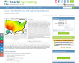
Students are introduced to measuring and identifying sources of air pollution, as …
Students are introduced to measuring and identifying sources of air pollution, as well as how environmental engineers try to control and limit the amount of air pollution. In Part 1, students are introduced to nitrogen dioxide as an air pollutant and how it is quantified. Major sources are identified, using EPA bar graphs. Students identify major cities and determine their latitudes and longitudes. They estimate NO2 values from color maps showing monthly NO2 averages from two sources: a NASA satellite and the WSU forecast model AIRPACT. In Part 2, students continue to estimate NO2 values from color maps and use Excel to calculate differences and ratios to determine the model's performance. They gain experience working with very large numbers written in scientific notation, as well as spreadsheet application capabilities.
Finding themselves in the middle of the Amazon rainforest after a plane …
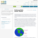
Finding themselves in the middle of the Amazon rainforest after a plane crash, students use map scales, keys, and longitude and latitude coordinates to figure out where they are. Then they work in groups to generate ideas and make plans. They decide where they should go to be rescued, the distance to that location, the route to take, and make calculations to estimate walking travel time.
In this lesson, students find their location on a map using Latitude …
In this lesson, students find their location on a map using Latitude and Longitudinal coordinates. They determine where they should go to be rescued and how best to get there.
This class is divided into a series of sections or “modules”, each …
This class is divided into a series of sections or “modules”, each of which concentrates on a particular large technology-related topic in a cultural context. The class will start with a four-week module on Samurai Swords and Blacksmithing, followed by smaller units on Chinese Cooking, the Invention of Clocks, and Andean Weaving, and end with a four-week module on Automobiles and Engines. In addition, there will be a series of hands-on projects that tie theory and practice together. The class discussions range across anthropology, history, and individual development, emphasizing recurring themes, such as the interaction between technology and culture and the relation between “skill” knowledge and “craft” knowledge.
Culture Tech evolved from a more extensive, two-semester course which formed the centerpiece of the Integrated Studies Program at MIT. For 13 years, ISP was an alternative first-year program combining humanities, physics, learning-by-doing, and weekly luncheons. Culture Tech represents the core principles of ISP distilled into a 6-unit seminar. Although many collections of topics have been used over the years, the modules presented here are a representative sequence.
In this problem-based learning (PBL) activity, students take on the role of …
In this problem-based learning (PBL) activity, students take on the role of a student research scientist and explore the role of solar energy in determining climate, focusing on the urban heat island effect. Students conduct research and compare temperatures between two cities, and determine the factors that are responsible for the difference exhibited between them. The lesson is supported by teacher notes, answer key, glossary and an appendix with information about using PBL in the classroom. This is the third of three activities in Investigating the Climate System: Energy, a Balancing Act, and serves as an authentic assessment for all three modules.
The concept of geocaching is introduced as a way for students to …
The concept of geocaching is introduced as a way for students to explore using a global positioning system (GPS) device and basic geographic information (GIS) skills. Students familiarize themselves with GPS, GIS, and geocaching as well as the concepts of latitude and longitude. They develop the skills and concepts needed to complete the associated activity while considering how these technologies relate to engineering. Students discuss images associated with GPS, watch a video on how GPS is used, and review a slide show of GIS basics. They estimate their location using latitude and longitude on a world map and watch a video that introduces the geocaching phenomenon. Finally, students practice using a GPS device to gain an understanding of the technology and how location and direction features work while sending and receiving data to a GIS such as Google Earth.
Students go on a GPS scavenger hunt. They use GPS receivers to …
Students go on a GPS scavenger hunt. They use GPS receivers to find designated waypoints and report back on what they found. They compute distances between waypoints based on the latitude and longitude, and compare with the distance the receiver finds.
Students take on the role of geographers and civil engineers and use …
Students take on the role of geographers and civil engineers and use a device enabled with the global positioning system (GPS) to locate geocache locations via a number of waypoints. Teams save their data points, upload them to geographic information systems (GIS) software, such as Google Earth, and create scale drawings of their explorations while solving problems of area, perimeter and rates. The activity is unique in its integration of technology for solving mathematical problems and asks students to relate GPS and GIS to engineering.
The marine environment is unique and requires technologies that can use sound …
The marine environment is unique and requires technologies that can use sound to gather information since there is little light underwater. The sea-floor is characterized using underwater sound and acoustical systems. Current technological innovations are allowing scientists to further understand and apply information about animal locations and habitat. Remote sensing and exploration with underwater vehicles allows scientists to map and understand the sea floor, and in some cases, the water column. In this lesson, the students will be shown benthic habitat images produced by GIS. These imaged will lead to a class discussion on why habitat mapping is useful and how current technology works to make bathymetry mapping possible. The teacher will then ask inquiry-based questions to have students brainstorm about the importance of bathymetry mapping.
With this activity, students use a globe to learn how a position …
With this activity, students use a globe to learn how a position on Earth can be described. They investigate how latitude can be found using the stars. Students learn what latitude and longitude are and how to use them to indicate a position on Earth. They investigate how in some locations on Earth, the direction of the midday sun can change over the year.
This activity introduces students to using Google Earth and adding layers to …
This activity introduces students to using Google Earth and adding layers to google earth, while re-enforcing plate tectonic concepts and evidence for plate tectonics. Outcomes: 1. Download Google Earth onto computer 2. Turn on/off layers within Google Earth 3. Be able to change measurement and use ruler within Google Earth 4. Determine latitude and longitude of ocean basin features 5. Be able to search for locations within Google Earth 6. Learn to upload new layers into Google Earth from .kmz files 7. Describe different plate boundaries, their locations and boundary interactions 8. Explain evidence for Plate Tectonics
Students are introduced to the concept of tracking and spatial movements of …
Students are introduced to the concept of tracking and spatial movements of animals in relation to the environments in which they live. Students improve their understanding of animal tracking and how technology is used in this process.
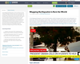
In the Mapping Earthquakes to Save the World activity, students leverage real-time …
In the Mapping Earthquakes to Save the World activity, students leverage real-time data to plot earthquakes on a world map. The fate of the world is in their hands – the President of the United States has asked for their help to save humankind. Students identify patterns in their data and connect earthquakes with tectonic plates, making recommendations back to the President about where people are safe and where people are most at risk. This activity was heavily inspired by a project from the Stevens Institute for Technology Center for Innovation in Engineering and Science Education.
The following lesson is an introduction to the ideas and implications of …
The following lesson is an introduction to the ideas and implications of animal tracking. Animal tracking is a useful method used within science and commercial industries. For instance, when planning the development coastal areas, animal presence and movement should be taken into consideration. The lesson engages students in an activity to monitor animal foraging behavior on a spatial scale. The students will break into groups and track each other's movements as they move through a pre-determined course. The results will be recorded both individually and collaboratively in an attempt to understand animal movement regarding foraging behavior. Students will also engage in a creative design activity, focusing on how they would design a tag for a marine animal of their choice. In conclusion, instructors will query the class on data interpretation and how spatial information is important in relation to commercial, conservation, and scientific research decisions.
In this unit, students learn the very basics of navigation, including the …
In this unit, students learn the very basics of navigation, including the different kinds of navigation and their purposes. The concepts of relative and absolute location, latitude, longitude and cardinal directions are explored, as well as the use and principles of maps and a compass. Students discover the history of navigation and learn the importance of math and how it ties into navigational techniques. Understanding how trilateration can determine one's location leads to a lesson on the global positioning system and how to use a GPS receiver. The unit concludes with an overview of orbits and spacecraft trajectories from Earth to other planets.
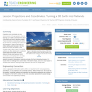
Projections and coordinates are key advancements in the geographic sciences that allow …
Projections and coordinates are key advancements in the geographic sciences that allow us to better understand the nature of the Earth and how to describe location. These innovations in describing the Earth are the basis for everything that is done in a GIS framework. Shape of the Earth is a critical starting point because in fact the Earth is not round but rather a more complex shape called a geoid. Coordinate systems are often referenced to a particular model shape of the Earth, but many different formats exist because not all coordinates work equally well in all areas. While projections and coordinates are abstract concepts in themselves, students eventually find them interesting because 1) it causes them to challenge their current ideas of the Earth's shape and 2) it is much easier to visualize these ideas for learning through interactive GIS such as Google Earth.
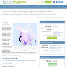
Cryptids, creatures of questionable existence, are used as a source of data …
Cryptids, creatures of questionable existence, are used as a source of data to guide students into the creation of their own GIS data layer in Google Earth. The activity serves the purpose of a tutorial to teach students how to make data layers with a simple subject. Then they use that skill on other topics such as plastics in their neighborhood.
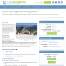
Students learn about the daily and annual cycles of solar angles used …
Students learn about the daily and annual cycles of solar angles used in power calculations to maximize photovoltaic power generation. They gain an overview of solar tracking systems that improve PV panel efficiency by following the sun through the sky.
No restrictions on your remixing, redistributing, or making derivative works. Give credit to the author, as required.
Your remixing, redistributing, or making derivatives works comes with some restrictions, including how it is shared.
Your redistributing comes with some restrictions. Do not remix or make derivative works.
Most restrictive license type. Prohibits most uses, sharing, and any changes.
Copyrighted materials, available under Fair Use and the TEACH Act for US-based educators, or other custom arrangements. Go to the resource provider to see their individual restrictions.