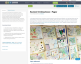
In the paper-based Ancient Civilizations activity, students create their own civilization and …
In the paper-based Ancient Civilizations activity, students create their own civilization and see how it fares over the years based on choices they make for location, animals, plants and natural resources. Students create an artistic rendering of their civilization, trade resources between their civilizations and go to war with an unnamed enemy. This activity was inspired by Guns, Germs and Steel by Jared Diamond.
Students will use both primary and secondary sources (links in lesson) to …
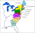
Students will use both primary and secondary sources (links in lesson) to research one or a group of the 13 original colonies and create a report or presentation. They will also identify the colonies on a map quiz. Being able to identify geographical locations and use map skills is always beneficial, for both school and beyond. This lesson will also provide students with the ability to compare and contrast different colonies and explain their importance to the development of a nation based on geographical connetions to industry/agriculture and their origination and it's impact on history. (For example, the colonies that began with a king's charter were more likely to have citizens who remained loyal to Britian during the War for Independence.)
World History Encyclopedia is a non-profit organization publishing the world's most-read history …
World History Encyclopedia is a non-profit organization publishing the world's most-read history encyclopedia. Its mission is to engage people with cultural heritage and to improve history education worldwide.
The website offers thousands of free history articles, with a writing style aimed at students from middle school level and up. Articles are complemented by videos, timelines, 3D models, and interactive maps. The search function offers many filters, including the possibiliy to search for primary source texts.
Additionally, the organization published free teaching materials in its education section (https://www.worldhistory.org/edu/).
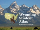
This activity is in the form of a story map and a video …
This activity is in the form of a story map and a video about important archaeological sites in Wyoming, which includes several interactive web maps that allow students to zoom in and out to compare locations of archaeological sites in Wyoming and click on for photos and more information. Students will be able to compare the different archaeological time periods and types of sites such as rock art, sacred sites and hunting sites. Students can explore sacred and historical sites important to the Lakota tribes greater detail at this story map about northeastern Wyoming and the Black Hills. This resource includes interactive maps and videos narrated by Lakota historian, Donovan Sprague. Students will explore locations of importance to the Lakota and hear legends associated with these places as well as historical events described from the perspective of indigenous people.
No restrictions on your remixing, redistributing, or making derivative works. Give credit to the author, as required.
Your remixing, redistributing, or making derivatives works comes with some restrictions, including how it is shared.
Your redistributing comes with some restrictions. Do not remix or make derivative works.
Most restrictive license type. Prohibits most uses, sharing, and any changes.
Copyrighted materials, available under Fair Use and the TEACH Act for US-based educators, or other custom arrangements. Go to the resource provider to see their individual restrictions.