All resources in Missouri OER PL Academy

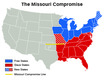
Missouri Compromise – Free vs. Slave States
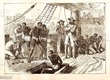
(View Complete Item Description)

The purpose of this activity is to introduce students to the Missouri Compromise and the issues associated with the expansion of slavery in the Antebellum period of United States history. Students will begin the activity by creating a map that represents the Missouri Compromise’s impact on the United States. This map will serve as a backdrop for the activity while introducing students to political and cultural sectionalism (northern and southern states and the issue of slavery) in the early 1800s. After students complete the map, they will answer several questions using it. Students will also be prompted to examine aggregated data from the 1820 Census and a map titled “Mapping Slavery in the Nineteenth Century” to make comparisons and draw conclusions about slavery, specifically in Missouri.

Material Type: Activity/Lab

Devastating Joplin, Missouri Tornado

(View Complete Item Description)

On May 22, 2011 an EF-5 Monster Tornado over a mile wide leveled portions of the Southwest side of Joplin, Missouri. Jeff and Kathryn Piotrowski knew that the atmosphere that day was going to be extremely volatile and Jeff mentioned many times in his forecast about storms near Joplin. No truer words were spoken as the day unfolded and a tornadic storm developed near Galena, Kansas which traveled on to Joplin

Material Type: Lecture

Investigative Case - "Swampeast Missouri"

(View Complete Item Description)

Students will explore wetland hydrology and biology and decide whether or not to restore a wetland or retain dams and drainage systems. (Note: this resource was added to OER Commons as part of a batch upload of over 2,200 records. If you notice an issue with the quality of the metadata, please let us know by using the 'report' button and we will flag it for consideration.)

Material Type: Assessment, Lesson Plan

Author: Developed for Lifelines Online by Michelle Fisher at Three Rivers Community College, Poplar Bluff, Missouri. (http://www.bioquest.org/lifeline/ (more info) )

Westward Bound – Illinois, Indiana, Missouri, and Ohio

(View Complete Item Description)

In this activity, students will learn about population movement, migration trends, and the westward expansion of the early 1800s. First, students will create a line graph that depicts changes in aggregated population data from 1800 to 1850 for Illinois, Indiana, Missouri, and Ohio. Using this graph, students will make data comparisons and draw conclusions. Next, students will compare the populations of several states between 1790 and 1850 and make conclusions that demonstrate their understanding of population trends in northern and southern states. This activity can spark discussion of sectionalism, slavery, and the different economic climate that took shape in the northern and southern states in the early 1800s.

Material Type: Activity/Lab

An Introduction to Psychological Statistics

(View Complete Item Description)

This work has been superseded by Introduction to Statistics in the Psychological Sciences available from https://irl.umsl.edu/oer/25/. - We are constantly bombarded by information, and finding a way to filter that information in an objective way is crucial to surviving this onslaught with your sanity intact. This is what statistics, and logic we use in it, enables us to do. Through the lens of statistics, we learn to find the signal hidden in the noise when it is there and to know when an apparent trend or pattern is really just randomness. The study of statistics involves math and relies upon calculations of numbers. But it also relies heavily on how the numbers are chosen and how the statistics are interpreted. This work was created as part of the University of Missouri’s Affordable and Open Access Educational Resources Initiative (https://www.umsystem.edu/ums/aa/oer). The contents of this work have been adapted from the following Open Access Resources: Online Statistics Education: A Multimedia Course of Study (http://onlinestatbook.com/). Project Leader: David M. Lane, Rice University. Changes to the original works were made by Dr. Garett C. Foster in the Department of Psychological Sciences to tailor the text to fit the needs of the introductory statistics course for psychology majors at the University of Missouri – St. Louis. Materials from the original sources have been combined, reorganized, and added to by the current author, and any conceptual, mathematical, or typographical errors are the responsibility of the current author.

Material Type: Textbook

Authors: Dan Osherson, Foster Garett C, Garett C Foster, Hebl Mikki, Mikki Hebl, Rice University, Rudy Guerra, Scott David, University Of Missouri-st Louis, Zimmer Heidi

Lesson 1: An Early Threat of Secession: The Missouri Compromise of 1820 and the Nullification Crisis

(View Complete Item Description)

Americans affirmed their independence with the ringing declaration that "all men are created equal." Some of them owned slaves, however,and were unwilling to give them up as they gave speeches and wrote pamphlets championing freedom, liberty, and equality. So "to form a more perfect union" in 1787, certain compromises were made in the Constitution regarding slavery. This settled the slavery controversy for the first few decades of the American republic, but this situation changed with the application of Missouri for statehood in 1819.

Material Type: Lesson Plan

A Cross-Section and Geologic History from Field Data Collected by Second Year Students in the St Francois Mountains of Missouri

(View Complete Item Description)

Often Geology students complete their degrees with little practical field experience beyond what they obtain at Field Camp. This exercise introduces students to field projects early in their studies. This introduction occurs while our Earth System History class takes a three-day field trip to St. Francois Mountains of eastern Missouri. Given a topographic map of the field area, students use their field notes to construct a cross-section and answer written questions regarding relative age, field relationships, and geologic history of the area. (Note: this resource was added to OER Commons as part of a batch upload of over 2,200 records. If you notice an issue with the quality of the metadata, please let us know by using the 'report' button and we will flag it for consideration.)

Material Type: Activity/Lab

Author: Michael Stewart

Legal Contexts of Education

(View Complete Item Description)

Acollection of readings relevant to local Saint Louis, Missouri state and United States federal, laws and cases as they relate to education policies. The readings are organized by topic, as shown below. The First Amendment Tinker v. Des Moines School Dist. Hazelwood School District v. Kuhlmeier Bethel School Dist. No. 403 v. Fraser What Does Free Speech Mean? The Fourth Amendment New Jersey v. T. L. O. What Does the Fourth Amendment Mean? The Eighth Amendment Ingraham v. Wright The Fourteenth Amendment Goss v. Lopez Honig v. Doe Missouri Laws Stewart v. Board of Ed. of Ritenour Smith v. Normandy School Dist. IDEA and IDEIA Cedar Rapids Community School Dist. v. Garret F. Burlington School Comm. v. Mass. Dept. of Ed. Stuart v. Nappi Link: MODESE Policy Segregation and the Fourteenth Amendment Brown v. Board of Education of Topeka Link: Missouri Revised Statutes 168.104-168.129

Material Type: Primary Source

Author: Vanessa Garry

American Literatures Prior to 1865

(View Complete Item Description)

This work was created as part of the University Libraries’ Open Educational Resources Initiative at the University of Missouri–St. Louis. A web version of this text can be found at https://umsystem.pressbooks.pub/alpt1865/. This anthology of American Literatures Prior to 1865, is organized chronologically into four units, focusing on Colonial Literature, Literature of Native American Perspectives and Discovery, Literature of Nineteenth Century Reform, and Literature of the New Nation. It includes introductions to the many authors included to enhance the reader's contextual understanding of the chosen texts. This anthology is essential reading for any student or scholar of Early American literature.

Material Type: Reading, Textbook

Author: Scott D. Peterson

CS Discoveries 2019-2020: Physical Computing Lesson 6.4: Input Unplugged

(View Complete Item Description)

In preparation for delving deeper into programming with App Lab, students will explore how a handful of different programs written in both Game Lab and App Lab handle taking input from the user. After comparing and contrasting the approaches they saw in the example apps, students group up to act out the two different models for input (conditionals in an infinite loop and asynchronous events) to gain a better understanding of how they work.

Material Type: Lesson Plan

Impact of Transatlantic Slave Trade on Western Africa

(View Complete Item Description)

This compilation of secondary sources gives an account for how the Transatlantic slave trade became a key economic feature of the Western coast of Africa, as well as an important economic feature of the "New World" colonies. This is a guided reading with questions throughout for the purpose of assessing students' understanding. Student's are prompted to mark the text for key details as they follow along. An excellent source to print or to use digitally. 

Material Type: Activity/Lab, Homework/Assignment, Reading

Author: Darren Swanson

10 Things You Can Do with ArcGIS Online and Story Maps

(View Complete Item Description)

Several new content pieces invite you to do hands-on work with web GIS technology: [1] 10 Things you can do with ArcGIS Online in education. These include: (1) Use web mapping applications. (2) Make your own map. (3) Get a school, club, or university organizational account in ArcGIS Online. (4) Use and modify existing curricular resources. (5) Explore the Living Atlas of the World. (6) Modify and ask questions of maps. (7) Conduct spatial analysis on mapped data. (8) Add multimedia to maps. (9) Explore your world in 3D, and (10) Map and analyze field-collected data. [2] Introduction and Advanced Work with Story Maps: Slides and hands-on exercises. These include how to build a story map from a web map, and how to build map tours, map journals, swipe, series, and other types of story maps. [3] Teaching with Web Apps. Set of resources and activities. These include examining Pacific typhoons in 3D, demographics of Zip Codes, creating viewsheds and buffers, and much more. [4] Spatial Analysis in Human Geography. These include the 1854 cholera epidemic in London (activity), a Boulder County hazards analysis (map), and an examination of the Human Development Index around the world (map). I created this content for the Esri mapping lab for the 2017 National Conference on Geography Education, but it can also be used to support your own professional development or for your own instruction.

Material Type: Activity/Lab, Data Set

Author: Joseph J. Kerski