The Office for Climate Education (OCE) launches an innovative online course: an …
The Office for Climate Education (OCE) launches an innovative online course: an opportunity for teachers all over the world to learn how to teach about climate change online and for free.
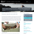
Over the past 40 years, some lobstermen in South Thomaston, Maine, say …
Over the past 40 years, some lobstermen in South Thomaston, Maine, say that they could "set their watches by the start of the lobster shedding event each season. In 2012, though, extreme warm ocean temperaturesan ocean heat wavecombined with early and repeated lobster shedding. The obvious changes in lobsters during this event galvanized many lobstermen to take the impacts of climate change seriously.
In 1667, John Milton published what he intended both as the crowning …
In 1667, John Milton published what he intended both as the crowning achievement of a poetic career and a justification of God’s ways to man: an epic poem which retold and reimagined the Biblical story of creation, temptation, and original sin. Even in a hostile political climate, Paradise Lost was almost immediately recognized as a classic, and one fate of a classic is to be rewritten, both by admirers and by antagonists. In this seminar, we will read Paradise Lost alongside works of 20th century fantasy and science fiction which rethink both Milton’s text and its source. Students should come to the seminar having read Paradise Lost straight through at least once; this can be accomplished by taking the IAP subject, Reading Paradise Lost (21L.995), or independently. Twentieth century authors will include C. S. Lewis (Perelandra, The Lion, the Witch and the Wardrobe) and Philip Pullman (His Dark Materials), as well as assorted criticism. Each week, one class meeting will focus on Milton, and the other on one of the modern novels.
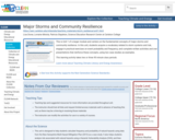
This is Unit 1 of a larger module and centers on the …
This is Unit 1 of a larger module and centers on the fundamental concepts of major storms and community resilience. In this unit, students acquire a vocabulary related to storm systems and risk, engage in practical exercises on event probability and frequency, and complete written activities and oral presentations that reinforce these concepts, using two case studies as examples.
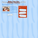
In this OLogy activity, kids learn about climate and atmospheric conditions by …
In this OLogy activity, kids learn about climate and atmospheric conditions by making their own weather station. The activity begins with an overview that explains that weather happens in the atmosphere, where conditions are always changing. Students are given step-by-step, illustrated directions to make a wind vane, a rain gauge and a barometer. The activity includes a printable Weather Chart and wind vane cutouts.
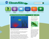
It’s hard to imagine life on Earth without oceans. The air you …
It’s hard to imagine life on Earth without oceans. The air you breathe used to be an ocean breeze. The water you drink was once in a cloud over the ocean.
The ocean is also important to the many species of plants and animals that call the water their home. This community of organisms is called an ecosystem.
Human-caused climate change is warming our planet, and the oceans are feeling the heat. Plants and animals in the ocean ecosystem are sensitive to changes in the ocean’s temperature. Some organisms can adapt to the change, but others can’t survive the warmer temperatures. Since so much life is dependent on these waters, it’s important to keep the oceans healthy!
Scientists are monitoring the temperature of the ocean with an instrument called the Moderate Resolution Imaging Spectroradiometer (MODIS) on NASA’s Aqua satellite. The satellite measures the temperature of the top millimeter of the ocean’s surface.
With this activity, learn to make a cool and tasty version of the ocean ecosystem at home!
This article examines the reading comprehension strategy known as making connections. It …
This article examines the reading comprehension strategy known as making connections. It involves linking what is being read (the text) to what is already known (schema, or background knowledge). The author provides links to four online resources that will help readers use the strategy in K-5 science and literacy classrooms. The article appears in the free, online magazine Beyond Weather and the Water Cycle, which integrates science and literacy instruction.
The reading strategy known as making connections can greatly enhance students' understanding …
The reading strategy known as making connections can greatly enhance students' understanding of any text. This article offers resources that teachers can use to instruct K-5 students in using the strategy. The free, online magazine Beyond Weather and the Water Cycle integrates science and literacy instruction. Each issue contains lessons and activities that combine literacy and science experiences.
This activity runs over two classroom sessions with a take-home assignment in …
This activity runs over two classroom sessions with a take-home assignment in between. During the initial classroom meeting students investigate the properties of minerals that would be make them suitable for use as a pigment in a water-based paint (streak, hardness, solubility). Students then work with natural materials, including powdered minerals, to make a palette of gouache paints (opaque watercolors) which students can keep.
Over the next week, students conduct online research to find a culture (past or present) that incorporates the class's limited color palette into their painted artifacts, and emulates their art form to create an art object using their paint. Students conduct research on the region and culture through a geological lens: where are they located? What is the climate? What is the general physiography (mountainous, volcanic, plains, etc)? Where do they get their pigments? Do the colors/paints have symbolic/spiritual meaning? What use/meaning would your homemade artifact have in this culture? This information is compiled into an abstract-like form, to be written up as a curatorial display tag in a museum gallery. In addition they must mark the location in which their culture exists on a blank world map. In week two, students display their works around the classroom, and post their "curatorial tag" and map beside their display. Students are asked to organize themselves (and their displays) by geographic region, in order to initiate student conversation and to place the exercise in a geographic context. In a gallery walk fashion, students examine each other's work, and document similarities and differences between the environments and styles, and the consistency of the limited palette of black-white-red/brown-yellow-(green). The class ends with an instructor-led discussion of the ubiquity of these colors due to the ubiquity of certain minerals in the sedimentary environment (white clay, hematite, limonite, along with charcoal), and leads into a discussion of mineral formation by weathering.
(Note: this resource was added to OER Commons as part of a batch upload of over 2,200 records. If you notice an issue with the quality of the metadata, please let us know by using the 'report' button and we will flag it for consideration.)
This article discusses the reading instruction strategy of predicting and shows how …
This article discusses the reading instruction strategy of predicting and shows how it applies to science learning in the elementary school grades. It appears in the free online magazine Beyond Weather and the Water Cycle, which provides a first introduction to the Seven Essential Principles of Climate Literacy.
This course aims to get students thinking about politics and policy as …
This course aims to get students thinking about politics and policy as a part of their everyday life. We treat politics as a struggle among competing advocates trying to persuade others to see the world as they do, working within a context that is structured primarily by institutions and cultural ideas. We’ll begin by developing a policymaking framework, understanding ideology, and taking a whirlwind tour of the American political system. Then, we’ll examine six policy issues in depth: health care, gun control, the federal budget, immigration reform, same-sex marriage, and energy and climate change.
In this learning activity, students analyze an actual dataset of the influence …
In this learning activity, students analyze an actual dataset of the influence of temperature on tree growth. They use mathematical and statistical concepts like slope equations and lines of best fit to determine the relationship. They are then asked to make predictions about future tree growth under different greenhouse gas emissions, interpreting data from climate models to make these predictions.
This unit is designed to give students an introduction to this pressing …
This unit is designed to give students an introduction to this pressing societal problems and to teach students how to analyze some of the compiled data on global warming through rates, ratios and proportions; students will also learn to make projections and predictions using slope, and linear and exponential functions.
To teach this unit, the teacher has to have at least a general knowledge of global warming, the greenhouse effect, and the carbon cycle. I thought that it was important to explain the basics of these topics. This unit is designed as a math unit, to help students gain a deeper understanding of linear functions, slope, exponential functions, as well as rates, ratios and proportions. Global warming, the carbon cycle, and the greenhouse effect, will be the real life application to which we will apply our mathematics.
This is a group mapping exercise that examines the many factors that …
This is a group mapping exercise that examines the many factors that affect the distribution and possible future distribution of malaria in North and South America.
(Note: this resource was added to OER Commons as part of a batch upload of over 2,200 records. If you notice an issue with the quality of the metadata, please let us know by using the 'report' button and we will flag it for consideration.)
The Malaysia Sustainable Cities Practicum is an intensive field-based course that brings …
The Malaysia Sustainable Cities Practicum is an intensive field-based course that brings 15 Graduate / Professional students to Malaysia to learn about and analyze sustainable city development in five cities in Malaysia. The students in the Practicum will help determine the extent to which these efforts have been successful. They will identify specific projects or policy-making efforts that the following year’s cohort of International Visiting Scholars can examine more closely. " Lead Faculty Professor Larry Susskind Teaching Assistants Jessica Gordon Yasmin Zaerpoor Administrative Staff Takeo Kuwabara Selmah Goldberg
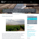
In the Arizona desert, farmers depend on an ample supply of irrigation …
In the Arizona desert, farmers depend on an ample supply of irrigation to grow their crops. As climate changes, irrigation managers face a host of issues to keep the water flowing.
In this video, Michael Mann and Peter Ramsdorf explore some of the …
In this video, Michael Mann and Peter Ramsdorf explore some of the information from the 2013 IPCC 5th report in light of public perceptions of climate science.
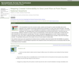
Spreadsheets Across the Curriculum/Geology of National Parks module. Students work with a …
Spreadsheets Across the Curriculum/Geology of National Parks module. Students work with a color-coded conditional-formatted spreadsheet map to work through a USGS report applying a coastal vulnerability index, examining real data related to relative sea-level change for different areas of the Californian coas,t including Point Reyes National Seashore.
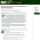
Spreadsheets Across the Curriculum/Geology of National Parks module. Students work with a …
Spreadsheets Across the Curriculum/Geology of National Parks module. Students work with a color-coded conditional-formatted spreadsheet map to work through a USGS report applying a coastal vulnerability index.
(Note: this resource was added to OER Commons as part of a batch upload of over 2,200 records. If you notice an issue with the quality of the metadata, please let us know by using the 'report' button and we will flag it for consideration.)
This activity introduces students to Greenland ice-melt data derived from passive microwave …
This activity introduces students to Greenland ice-melt data derived from passive microwave remote sensing between the years 1979 and 2007. Students make a quantitative comparison between the two years using the mapping program ArcGIS. Students are provided with NASA raster images in GeoTiff form that show Greenland ice melt extent over two of the years on record (1979 ad 2007). Students then draw polygons over these raster files and calculate a change in area between the years on record. While tools exist in ArcGIS to quantify the extent of ice melt using the raster images themselves, drawing polygons is an important and often little-practiced skill in ArcGIS, and is therefore the focus of this activity. This activity can also be modified for more advanced map-makers working with raster files, who need practice using additional tools in the Arc Toolbox. However, raster calculations are not generally a skill covered in an introductory GIS course. The activity is meant to reinforce important map-making skills (like drawing polygons and creating new geodatabases) using a data set that explores a real-world application of ArcGIS for Earth Science students. While any two (or more!) years on record can be used, 1979 and 2007 have been used to explore extremes in the data. You can learn more about the data set and the GeoTiff images here: http://nsidc.org/greenland-today/. The activity was designed for students with prior mapping skills, but can be modified for those who have little to no mapping experience (step by step instructions can be provided, upon request).
No restrictions on your remixing, redistributing, or making derivative works. Give credit to the author, as required.
Your remixing, redistributing, or making derivatives works comes with some restrictions, including how it is shared.
Your redistributing comes with some restrictions. Do not remix or make derivative works.
Most restrictive license type. Prohibits most uses, sharing, and any changes.
Copyrighted materials, available under Fair Use and the TEACH Act for US-based educators, or other custom arrangements. Go to the resource provider to see their individual restrictions.