In this activity, students analyze data maps of sea surface temperature anomalies …
In this activity, students analyze data maps of sea surface temperature anomalies for a 14-year interval and create an ENSO time line in a case study format. Based on their findings, students determine the recurrence interval of the ENSO system.
In this activity, students examine a pair of satellite images of the …
In this activity, students examine a pair of satellite images of the ocean and determine whether there is a relationship between the height of ocean waves and the sea level. Data from the two images are plotted side by side and students discuss the reasons for their findings. The resource includes the images and a student worksheet. Summary background information, data and images supporting the activity are available on the Earth Update data site. To complete the activity, students will need to access the Space Update multimedia collection, which is available for download and purchase for use in the classroom.
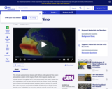
This video segment adapted from NASA's Goddard Space Flight Center describes El …
This video segment adapted from NASA's Goddard Space Flight Center describes El Niño, how it forms, and the chain reaction of consequences it triggers around the globe.
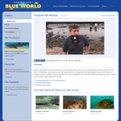
In this video, Jonathan travels to the Micronesian island of Yap in …
In this video, Jonathan travels to the Micronesian island of Yap in the middle of the Pacific to investigate large gatherings of the world's largest rayŰÓthe manta. A research program there is tracking dozens of these animals and Jonathan learns what they're doing hanging around certain coral heads every morning. Please see the accompanying lesson plan on tides for educational objectives, discussion points and classroom activities.
In this video Jonathan visits the New England Aquarium as a volunteer …
In this video Jonathan visits the New England Aquarium as a volunteer aquarist for a day to learn what it takes to care for thousands of fish in dozens of exhibits, up to the massive 200,000 gallon Giant Ocean Tank (GOT). What he finds is an eye openerŰÓitŰŞs not all fun and games. Maintaining an aquarium is serious work. But it does have its benefits, as Jonathan discovers while diving in the GOT and feeding the sharks. This segment won a New England Emmy Award! Please see the accompanying study guide for educational objectives and discussion points.
Students are assigned unique roles and work independently to solve a complex …
Students are assigned unique roles and work independently to solve a complex problem from the perspective of their role (i.e. sociologist, educator, historian, etc.) Students then work collaboratively to present their findings and action plan to the "tribal council".
(Note: this resource was added to OER Commons as part of a batch upload of over 2,200 records. If you notice an issue with the quality of the metadata, please let us know by using the 'report' button and we will flag it for consideration.)
Thanks to the Disney/Pixar movie "Finding Nemo", virtually everyone has heard of …
Thanks to the Disney/Pixar movie "Finding Nemo", virtually everyone has heard of the clownfish. In this video, Jonathan travels the Pacific to investigate the behavior of real clownfish. Even though they don't actually talk in real life, they are beautiful and fascinating fish to observe. Please see the accompanying lesson plan for educational objectives, discussion points and classroom activities.
In this problem-based learning module, students work in teams to examine a …
In this problem-based learning module, students work in teams to examine a broad array of information related to water quality in Lower Wheeling Creek and the Wheeling Creek watersheds in Wheeling, West Virginia. This module is part of Exploring the Environment.
In this video, Jonathan examines the biology of coral reefs and their …
In this video, Jonathan examines the biology of coral reefs and their importance to the marine ecosystem. Please see the accompanying lesson plan that discusses pH and ocean acidification for educational objectives, discussion points and classroom activities.
Millions of fish eggs from the Caribbean get stuck in the gulf …
Millions of fish eggs from the Caribbean get stuck in the gulf stream every year and drift thousands of miles north where they hatch. Unfortunately, when winter comes, the baby fish will die. In this video, Jonathan joins the New England Aquarium Dive Club on a tropical fish rescue in Rhode Island where they catch some of these fish in the fall before water temperatures plummet. The fish go to the New England AquariumŰŞs exhibits. Please see the accompanying study guide for educational objectives and discussion points.
This video explains what El NiÃo is and provides the definition of …
This video explains what El NiÃo is and provides the definition of El NiÃo. It goes into detail about the devastating terrestrial and aquatic effects an El NiÃo can have on living organisms and the climate (disease, storms, floods, tornadoes, drought, wildfire, increased air temperatures, decreased water temperatures, etc).
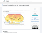
In this middle school and high school unit, students engage with 360° …
In this middle school and high school unit, students engage with 360° virtual reality tours, authentic Arctic datasets, and app-based labs to construct models and explanations for the unit driving question, "Why might the Arctic be warming twice as fast as the rest of the world?"
This video demonstrates students measuring the alkalinity of a water sample, using …
This video demonstrates students measuring the alkalinity of a water sample, using an alkalinity test kit. The resource includes a video and a written transcript, and is supported by the Alkalinity Protocol in the GLOBE Teacher's Guide. This is one of seven videos on hydrology in a 24-part instructional video series describing scientific protocols used by GLOBE (Global Learning and Observation to Benefit the Environment), a worldwide, hands-on, K-12 school-based science education program.
The purpose of this activity is to identify global patterns and connections …
The purpose of this activity is to identify global patterns and connections in environmental data contained in the GLOBE Earth Systems Poster, to connect observations made within the Earth Systems Poster to data and information at the National Snow and Ice Data Center, and to understand the connections between solar energy and changes at the poles, including feedback related to albedo.
This is an activity designed to allow students who have been exposed …
This is an activity designed to allow students who have been exposed to the El NiÃo-Southern Oscillation to analyze the La NiÃa mechanism and predict its outcomes in a case study format.
This Earth Exploration Toolbook chapter is a detailed computer-based exploration in which …
This Earth Exploration Toolbook chapter is a detailed computer-based exploration in which students learn how various climatic conditions impact the formations of sediment layers on the ocean floor. They analyze sediment core data from the Ross Ice Shelf in Antarctica for evidence of climate changes over time. In addition, they interact with various tools and animations throughout the activity, in particular the Paleontological Stratigraphic Interval Construction and Analysis Tool (PSICAT) that is used to construct a climate change model of a sediment core from core images.
This short NASA video focuses on the Aquarius satellite, which was launched …
This short NASA video focuses on the Aquarius satellite, which was launched in 2011 to observe how variations in ocean salinity relate to climatic changes. By measuring salinity globally, Aquarius shows the ocean's role in climate change and climate's effects on ocean circulation.
Students will review current ocean pressures related to overfishing and human impacts …
Students will review current ocean pressures related to overfishing and human impacts on ocean ecosystems. By examining data collected in relation to the presence of marine reserves, students will explore long-term strategies for protecting ocean resources. Students will review scientific data to assess biomass, biodiversity, and reproductive success of fishery stocks in a marine protected area (MPA) and propose a location for the establishment of a marine reserve in the Channel Islands, California.
(Note: this resource was added to OER Commons as part of a batch upload of over 2,200 records. If you notice an issue with the quality of the metadata, please let us know by using the 'report' button and we will flag it for consideration.)
Navigational tools and methods of early voyagers provide the background and contrast …
Navigational tools and methods of early voyagers provide the background and contrast to the satellite images and models used today. Students complete mapping activities based on historical data from Columbus and Blith. Students will also use a computer model of ocean currents to investigate the movement of objects drifting on the ocean surface. Note that this is lesson one of five on the Ocean Motion website. Each lesson investigates ocean surface circulation using satellite and model data and can be done independently. See Related URL's for links to the Ocean Motion Website which provide science background information, data resources, teacher material, student guides and a lesson matrix.
No restrictions on your remixing, redistributing, or making derivative works. Give credit to the author, as required.
Your remixing, redistributing, or making derivatives works comes with some restrictions, including how it is shared.
Your redistributing comes with some restrictions. Do not remix or make derivative works.
Most restrictive license type. Prohibits most uses, sharing, and any changes.
Copyrighted materials, available under Fair Use and the TEACH Act for US-based educators, or other custom arrangements. Go to the resource provider to see their individual restrictions.