This course helps in developing skills as science communicators through projects and …
This course helps in developing skills as science communicators through projects and analysis of theoretical principles. Case studies explore the emergence of popular science communication over the past two centuries and consider the relationships among authors, audiences and media. Project topics are identified early in the term and students work with MIT Museum staff. Projects may include physical exhibits, practical demonstrations, or scripts for public programs.
This module addresses the real problem of determining the density of the …
This module addresses the real problem of determining the density of the Earth and invites the student to figure out how to solve the problem.
(Note: this resource was added to OER Commons as part of a batch upload of over 2,200 records. If you notice an issue with the quality of the metadata, please let us know by using the 'report' button and we will flag it for consideration.)
This book presents 49 space-related math problems published weekly on the SpaceMath@NASA …
This book presents 49 space-related math problems published weekly on the SpaceMath@NASA site during the 2011-2012 academic year. The problems utilize information, imagery, and data from various NASA spacecraft missions that span a variety of math skills in pre-algebra and algebra.
Students use a microphone and Vernier LabQuest to record the sound of …
Students use a microphone and Vernier LabQuest to record the sound of a finger-snap echo in a 1-2 meter cardboard tube. Students measure the time for the echo to return to the microphone, and measure the length of the tube. Using their measurements, students determine the speed of sound. While other authors have produced similar labs, this version includes uncertainty analysis consistent with effective measurement technique as presented in the module Measurement and Uncertainty.
This portal, published by the University of Florida/Institute of Food and Agricultural …
This portal, published by the University of Florida/Institute of Food and Agricultural Science (IFAS) Extension, offers a selection of links to information about water management issues. There is a 'Beginner's Guide to Water Management', which provides a basic introduction to the terminology and concepts used in water management. Other links access information on management in coastal waters, the impact of climate change on water resources, the use of stormwater as an alternative supply, wastewater management, and many others.
Students explore and experiment with various objects to find which materials will …
Students explore and experiment with various objects to find which materials will float or sink. They record predictions and results, and generate ideas about the properties of materials that float or sink.
Try the new "Ladybug Motion 2D" simulation for the latest updated version. …
Try the new "Ladybug Motion 2D" simulation for the latest updated version. Learn about position, velocity, and acceleration vectors. Move the ball with the mouse or let the simulation move the ball in four types of motion (2 types of linear, simple harmonic, circle).
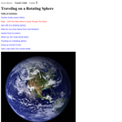
This lesson applies the science and math of the rotation of a …
This lesson applies the science and math of the rotation of a sphere to water and wind movements on Earth. Students are introduced to convection, the Trade Winds and the Coriolis Force. Using an online visualizer, students generate trajectories and then analyze course patterns and latitudinal changes in strength. Note that this is lesson two of five on the Ocean Motion website. Each lesson investigates ocean surface circulation using satellite and model data and can be done independently. See Related URL's for links to the Ocean Motion Website that provide science background information, data resources, teacher material, student guides and a lesson matrix.
In this module, students are asked to devise a way of graphically …
In this module, students are asked to devise a way of graphically plotting the density variations with depth in the Earth.
(Note: this resource was added to OER Commons as part of a batch upload of over 2,200 records. If you notice an issue with the quality of the metadata, please let us know by using the 'report' button and we will flag it for consideration.)
This hands-on activity will provide students with an understanding of the issues …
This hands-on activity will provide students with an understanding of the issues that surround environmental clean-up. Students will create their own oil spill, try different methods for cleaning it up, and then discuss the merits of each method in terms of effectiveness (cleanliness) and cost. They will be asked to put themselves in the place of both an environmental engineer and an oil company owner who are responsible for the clean-up.
In this activity, students play the roles of "time travel agents" creating …
In this activity, students play the roles of "time travel agents" creating an advertisement for a geologic time period which has been assigned to them. They will use the Earth Science Reference Tables (available on the internet) to learn some basic facts about their assigned period. A rubric for assessing student understanding is provided.
The Champlain Lowlands tour is part of the New York Landscape Regions …
The Champlain Lowlands tour is part of the New York Landscape Regions Collection of Google Earth tours, created by a group of New York State science educators. This tour includes views of the gorge of the Ausable River, cut through Late Cambrian Potsdam Sandstone, and the geology of the Champlain Thrust Fault, a low angle thrust fault formed as the proto-Atlantic Ocean closed during the Taconic Oregeny. When it was still connected to the ocean, Lake Champlain was home to whales, whose fossils are now entombed in the lake sediments. The tour also includes classroom activities for students.
The activity describes Eratosthenes' experiments which determined that the Earth is spherical, …
The activity describes Eratosthenes' experiments which determined that the Earth is spherical, rather than flat. Students reproduce Eratosthenes' methods using a slice of pizza to calculate the circumference of the entire pie.
This course introduces theoretical and practical principles of design of oceanographic sensor …
This course introduces theoretical and practical principles of design of oceanographic sensor systems. Topics include: transducer characteristics for acoustic, current, temperature, pressure, electric, magnetic, gravity, salinity, velocity, heat flow, and optical devices; limitations on these devices imposed by ocean environments; signal conditioning and recording; noise, sensitivity, and sampling limitations; and standards. Lectures by experts cover the principles of state-of-the-art systems being used in physical oceanography, geophysics, submersibles, acoustics. For lab work, day cruises in local waters allow students to prepare, deploy and analyze observations from standard oceanographic instruments.
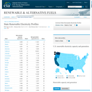
This profile provides maps, charts, and tables pertaining to state capacity and …
This profile provides maps, charts, and tables pertaining to state capacity and generation of renewable electricity. Tables include data for total net summer capacity and total net generation with rankings for each category. Users can view this data alphabetically by state, by capacity, or by generation. An interactive map allows users to navigate to specific state profiles and view the top 10 renewable capacity states simultaneously.
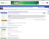
This is an in-class activity. I used it relatively early in the …
This is an in-class activity. I used it relatively early in the semester, after covering the basic water properties portion of the class. I use the relationship between temperature/salinity/density to begin discussing vertical movement of water. The first purpose of this activity is to reinforce the concepts that have just been explained about the relationship between temperature and density and salinity and density. The second purpose is to bring these ideas back to what they have learned about density differences. Finally, the activity is also designed to help them learn how to read graphs.
(Note: this resource was added to OER Commons as part of a batch upload of over 2,200 records. If you notice an issue with the quality of the metadata, please let us know by using the 'report' button and we will flag it for consideration.)
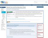
This homework problem introduces students to Marcellus shale natural gas and how …
This homework problem introduces students to Marcellus shale natural gas and how an unconventional reservoir rock can become an attractive hydrocarbon target. It is designed to expand students' understanding of hydrocarbon resources by introducing an unconventional natural gas play. Students explore the technological factors that make conventional source rocks attractive reservoir rocks and how this advance impacts both U.S. energy supply and the environment.
This is a lesson about elemental spectra. Learners will compare known elemental …
This is a lesson about elemental spectra. Learners will compare known elemental spectra with spectra of Titan and Saturn’s rings from a spectrometer aboard the NASA Cassini spacecraft. They identify the elements visible in the planetary and lunar spectra. The activity is part of Project Spectra, a science and engineering program for middle-high school students, focusing on how light is used to explore the Solar System.
This is an exercise in which students are reintroduced to geologic maps …
This is an exercise in which students are reintroduced to geologic maps and encouraged to "deconstruct" the map into constituent elements in order to understand the geologic history of the area. The preceding lectures in the course have recapitulated material that the students have covered in Introduction to Physical Geology. During class, the students work through the maps that were part of lab exercises in the Intro level course, so that basic concepts are recalled (superposition, cross-cutting relationships, basic faults and folds). The final product is a geologic history of this map area.
(Note: this resource was added to OER Commons as part of a batch upload of over 2,200 records. If you notice an issue with the quality of the metadata, please let us know by using the 'report' button and we will flag it for consideration.)
No restrictions on your remixing, redistributing, or making derivative works. Give credit to the author, as required.
Your remixing, redistributing, or making derivatives works comes with some restrictions, including how it is shared.
Your redistributing comes with some restrictions. Do not remix or make derivative works.
Most restrictive license type. Prohibits most uses, sharing, and any changes.
Copyrighted materials, available under Fair Use and the TEACH Act for US-based educators, or other custom arrangements. Go to the resource provider to see their individual restrictions.