Students use basic aqueous geochemistry knowledge to investigate controls of the atmospheric …
Students use basic aqueous geochemistry knowledge to investigate controls of the atmospheric carbon dioxide level on pH values of the wet precipitation at standard conditions (25 oC, 1 atmospheric pressure).
(Note: this resource was added to OER Commons as part of a batch upload of over 2,200 records. If you notice an issue with the quality of the metadata, please let us know by using the 'report' button and we will flag it for consideration.)
This activity provides the hydrogeology students an exercise to understand specific discharge, …
This activity provides the hydrogeology students an exercise to understand specific discharge, hydraulic conductivity, and porous media. They will actually use a Darcy column to gather data on porous media, as well as calculate and understand the hydrologic properties of the materials.
(Note: this resource was added to OER Commons as part of a batch upload of over 2,200 records. If you notice an issue with the quality of the metadata, please let us know by using the 'report' button and we will flag it for consideration.)
This assignment is designed to expose students in my undergraduate 3 credit …
This assignment is designed to expose students in my undergraduate 3 credit non lab elective geohydrology course to a variety of hydrogeological environments and groundwater issues/problems that exist in the United States. Much of the course (field trip and local groundwater contamination case study) highlights and emphasizes understanding of the shallow unconsolidated aquifers in Michigan. Students use as their main source of information the data and illustration rich professional USGS Groundwater Atlases. Using this resource, in this activity students learn about the structure of aquifers in volcanic rock, karst and permafrost regions. They teach their fellow students about groundwater problems that result due due to overpumping, subsidence, sinkholes, saltwater intrusion and coal mining.
Key words: hydrogeologic environments, water supply and water quality problems, aquifers
(Note: this resource was added to OER Commons as part of a batch upload of over 2,200 records. If you notice an issue with the quality of the metadata, please let us know by using the 'report' button and we will flag it for consideration.)
This activity is for students to work in teams (2012) or individually …
This activity is for students to work in teams (2012) or individually (2013) to develop a project (such as a physical or numerical model), survey based research, case study, technical briefs on a remediation technology, etc. of the students' choice, based on their understanding of and interest in the subjects covered in the class. This is used in the GL 199 Hydrogeology course, which is offered through the Department of Geology and Environmental Sciences at Norwich University. This is an experimental course that has not made it to the course catalogue as yet. It is currently offered to students majoring in Geology, with an acknowledgement that a course in hydrogeology is a desirable component of a Geology curriculum. Environmental Science students are encouraged to take it to deepen their understanding of subsurface processes. This course is considered a science elective for Civil and Environmental Engineering majors, and greatly complements the Hydrology, and Soils and Materials classes that are a part of the regular CE&E curriculum. Students from freshmen through seniors across these three majors are accepted into the course. With a cross section of majors and academic years in the class, it was determined that a project that has students thinking about a topic of their choice and developing fundamental research and collaboration skills is critical to meeting common workplace demands.
(Note: this resource was added to OER Commons as part of a batch upload of over 2,200 records. If you notice an issue with the quality of the metadata, please let us know by using the 'report' button and we will flag it for consideration.)
This module discusses the hydrologic cycle and its impacts on the planet …
This module discusses the hydrologic cycle and its impacts on the planet Earth. Additionally, the module addresses connections between the hydrologic cycle, climate and the impacts humans have had on the cycle.
Detailed, annotated example of Socratic questioning for topics of hydrologic cycle, streamflow …
Detailed, annotated example of Socratic questioning for topics of hydrologic cycle, streamflow hydrographs, and impacts of land-use change on streamflow.
(Note: this resource was added to OER Commons as part of a batch upload of over 2,200 records. If you notice an issue with the quality of the metadata, please let us know by using the 'report' button and we will flag it for consideration.)
Students explore for water on Mars using impact crater morphology. During this …
Students explore for water on Mars using impact crater morphology. During this lab, students: learn to use the equation writing and graphing capabilities in Microsoft Excel, thendevelop and apply an impact crater depth-diameter relationship in an effort to constrain the depth to a possible water-rich layer beneath one or more portions of the surface of Mars!
(Note: this resource was added to OER Commons as part of a batch upload of over 2,200 records. If you notice an issue with the quality of the metadata, please let us know by using the 'report' button and we will flag it for consideration.)
This project is a way to assemble information about geology, hydrogeology, and …
This project is a way to assemble information about geology, hydrogeology, and soils into a coherent whole in a way that may otherwise not happen in any one class. The "critical zone" concept ties the pieces together. This project is not tied to a course but I have used it as a component of a senior assessment for geology students.
(Note: this resource was added to OER Commons as part of a batch upload of over 2,200 records. If you notice an issue with the quality of the metadata, please let us know by using the 'report' button and we will flag it for consideration.)
In this lab, students investigate groundwater flow and water quality within a …
In this lab, students investigate groundwater flow and water quality within a groundwater well field on the CSU campus. The well field is part of the GroundWater Education and Teaching (GetWET) Observatory south of the Hilton Inn off Centre Drive. Students determine water flow paths and rates as well as measure water quality parameters such as water temperature, pH, electrical conductivity, and dissolved oxygen.
Materials needed for this lab include:
Groundwater equipment: Groundwater well or wells adjacent to a perennial stream. Water quantity equipment: Electronic water meter, staff, plate, tape, stop watch, and float to measure surface velocity. Water quality equipment: pH, temperature specific conductance, and dissolved oxygen meters, bailer, and bucket to collect samples. Other equipment: Map of site showing location of wells and stream.
(Note: this resource was added to OER Commons as part of a batch upload of over 2,200 records. If you notice an issue with the quality of the metadata, please let us know by using the 'report' button and we will flag it for consideration.)
Students are presented with examples of the types of problems that environmental …
Students are presented with examples of the types of problems that environmental engineers solve, specifically focusing on water quality issues. Topics include the importance of clean water, the scarcity of fresh water, tap water contamination sources, and ways environmental engineers treat contaminated water.
The main goal of this multi-part field and lab exercise is to …
The main goal of this multi-part field and lab exercise is to introduce students to practical aspects of soil and water geochemistry. Some of the analyses for this lab are conducted in the field using field analytical instruments and rest of the analyses is conducted in a wet chemistry/geochemistry lab. There are several objectives: 1. Learn how to sample water and soil samples in a safe and effective manner 2. Collect basic aqueous chemical parameters in the field 3. Compare field collected data with that obtained using advanced instruments in the laboratory 4. Determine bulk physical and chemical properties of the soils in the lab 5. Determine trace and major element concentrations of the soils in the laboratory At the end of this exercise students will gain a better appreciation for how soil and water quality is assessed in multiple ways. They are also introduced to basic "tools-of-the-trade" in the environmental geochemistry and also using Excel to make simple and advanced calculations as well as for plotting data. During preparation of lab reports, they are introduced to basic elements of an effective data-based technical paper.
Key words: urban watershed, soil chemistry, water chemistry, aqueous geochemistry, field analysis, analytical chemistry
(Note: this resource was added to OER Commons as part of a batch upload of over 2,200 records. If you notice an issue with the quality of the metadata, please let us know by using the 'report' button and we will flag it for consideration.)
This assignment is designed as a final project for students in my …
This assignment is designed as a final project for students in my undergraduate 3 credit non lab elective geohydrology course. Students work in pairs to analyze an actual, local contaminated site (Delphi) and use raw data from consulting reports (boring logs, water levels, chemical water analyses) to prepare a geologic cross-section, water table map and contaminant plume map. Students are assigned different lines of cross section, water level dates and contaminant types. Students examine the variety of different figures and maps to better characterize hydrogeologic and water quality conditions over the entire site and answer some assigned questions. This project is an opportunity for students to apply skills they learned in the course (contouring, groundwater flow) to investigate an existing groundwater contamination event. It also provides the kind of "practical" experience the students can highlight in a job interview.
Key words: Groundwater contamination, case study, TCE
(Note: this resource was added to OER Commons as part of a batch upload of over 2,200 records. If you notice an issue with the quality of the metadata, please let us know by using the 'report' button and we will flag it for consideration.)
This activity is an outdoor lab in which students investigate the process …
This activity is an outdoor lab in which students investigate the process of evaporation, record their findings, and use the data to make connections to the environment around them.
This activity is used in my groundwater flow modeling class (GEOS-724), a …
This activity is used in my groundwater flow modeling class (GEOS-724), a class for upper-level undergraduates and graduate students. In advance, the students receive an introduction to MATLAB and basic programming constructs, and background on the use of finite difference discretizations for solving partial differential equations.
The problem being solved here is a (relatively) simple steady-state, linear groundwater flow problem. The code presents different numerical methods for solving a seminal groundwater flow problem - the Toth problem (as solved by J. Toth http://onlinelibrary.wiley.com/doi/10.1029/JZ068i016p04795/abstract). The solution to the Toth problem shows that if the water table is a muted expression of surficial topography, then groundwater organizes itself into groundwater flow "cells" of varying expanse.
This problem - which is familiar to most groundwater modelers - provides a baseline for discussing differences in solution methods for numerical models. In this script, different solution styles tested include: 1) A "direct" matrix inversion method which is exact but somewhat memory intensive; 2) An iterative but relatively inefficient "point Jacobi" method; and 3) A more efficient Gauss-Seidel iterative method.
After running this script, students are asked to explore aspects of the solutions and comment on their benefits and drawbacks. For example: -Which solution method appears to be the most accurate, based on the problem statement (for instance the students should check that streamlines do not intersect no-flow boundaries) -Which solution requires the least / most memory to compute? -Which solution is the fastest to compute? -Which solution obtains the most reasonable mass balance? -How do the solutions perform if the discretization is increased or other parameters are varied (such as iteration "convergence" parameters)?
(Note: this resource was added to OER Commons as part of a batch upload of over 2,200 records. If you notice an issue with the quality of the metadata, please let us know by using the 'report' button and we will flag it for consideration.)
This assignment offers students several problems that help them understand the basic …
This assignment offers students several problems that help them understand the basic of mixing models and their use in understanding the controls on water quality in the environment. The purpose of the assignment is to help students integrate across the various topics in environmental chemistry in the context of flow and transport. Students will hopefully learn how reactive and non-reactive tracers can be used in conjunction to fully understand a chemical system.
(Note: this resource was added to OER Commons as part of a batch upload of over 2,200 records. If you notice an issue with the quality of the metadata, please let us know by using the 'report' button and we will flag it for consideration.)
The students will use activities to understand atomic mass and isotopes and …
The students will use activities to understand atomic mass and isotopes and stable isotopic fractionation in the hydrologic system.
(Note: this resource was added to OER Commons as part of a batch upload of over 2,200 records. If you notice an issue with the quality of the metadata, please let us know by using the 'report' button and we will flag it for consideration.)
Our students will be studying and exploring the human impact on groundwater. …
Our students will be studying and exploring the human impact on groundwater. They will study the water deprivation impacts both locally and in the San Joaquin Valley. Students will explore and come to understand the benefits of collecting rainwater. We partnered with the City of Eugene and had the wonderful Jackie come in. Our students brought in many of the materials including cardboard boxes, empty plastic containers (sour cream, water bottles,etc), tin foil, wax paper, duct tape,etc. We as teachers provided the underground sprinkler tubing cutting material, more tape and supplies. We tested this project with our 5th graders so we could make improvements and continue this project next year. In order to complete this project, we needed a full three weeks of working for an hour plus every day. We incorporated this project into our reading and science timeline.
Freshmen enrolled in the Spaceship Earth Living Learning Community conduct research on …
Freshmen enrolled in the Spaceship Earth Living Learning Community conduct research on a real project that is formulated and conducted during a 2-semester academic year.
(Note: this resource was added to OER Commons as part of a batch upload of over 2,200 records. If you notice an issue with the quality of the metadata, please let us know by using the 'report' button and we will flag it for consideration.)
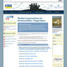
This kit explores how sustainability within the Finger Lakes region of New …
This kit explores how sustainability within the Finger Lakes region of New York has been presented in the media with a particular focus on issues related to food, water and agriculture. Each of the seven lessons integrates media literacy and critical thinking with key knowledge and concepts related to sustainability. This kit is a companion to the nineteen-lesson collection, Media Constructions of Sustainability: Food, Water and Agriculture.
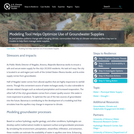
As Public Works Director of Nogales, Arizona, Alejandro Barcenas works to ensure …
As Public Works Director of Nogales, Arizona, Alejandro Barcenas works to ensure a safe and secure water supply for the city’s 20,500 residents. His task isn’t easy: the city is located in an arid region just north of the United States–Mexico border, and its entire supply comes from groundwater.
Half of Nogales’ water comes from alluvial aquifers that are highly responsive to rainfall events. Though this convenient source of water recharges easily, it is also vulnerable to climate-related changes such as reduced precipitation and increased evaporation. The other half of the city’s groundwater comes from a lower-quality source—this water is more expensive to produce. To optimize the use of the two sources of groundwater into the future, Barcenas is contributing to the development of a modeling tool that simulates how the aquifers may change in response to climate.
No restrictions on your remixing, redistributing, or making derivative works. Give credit to the author, as required.
Your remixing, redistributing, or making derivatives works comes with some restrictions, including how it is shared.
Your redistributing comes with some restrictions. Do not remix or make derivative works.
Most restrictive license type. Prohibits most uses, sharing, and any changes.
Copyrighted materials, available under Fair Use and the TEACH Act for US-based educators, or other custom arrangements. Go to the resource provider to see their individual restrictions.