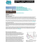
Coalbed methane (CH4) is a natural gas and valuable energy resource that …
Coalbed methane (CH4) is a natural gas and valuable energy resource that occurs in coal beds. This site, hosted by an energy development corporation, explains the geology and stratigraphy of Wyoming in the context of the formation of coalbed methane and its occurrence in Wyoming. Maps, cross sections, stratigraphic columns and fence diagrams are provided to explain Cretaceous and Tertiary coalbed methane-plays in Wyoming.
This article is about the latest remake of Jules Verne's popular 144-year-old …
This article is about the latest remake of Jules Verne's popular 144-year-old novel Journey to the Center of the Earth that also provides links to the American Geologic Institute's (AIG) Educator Guide for using the movie (Journey to the Center of the Earth 3D) to interest students in geology and earth science.
This is an activity about planetary sizes and distances. Learners will construct …
This is an activity about planetary sizes and distances. Learners will construct a scale model of the Earth, Earth’s Moon and Mars in relation to each other using balloons. They will use this model to predict distances and reflect on how scientists use models to construct explanations through the scientific process. The lesson models scientific inquiry using the 5E instructional model and includes teacher notesand vocabulary.
This lab helps students bring together their ability to describe and identify …
This lab helps students bring together their ability to describe and identify rocks and to push students to think about how the rocks formed based upon their understanding of the geological processes taking place at certain tectonic boundaries.
(Note: this resource was added to OER Commons as part of a batch upload of over 2,200 records. If you notice an issue with the quality of the metadata, please let us know by using the 'report' button and we will flag it for consideration.)
This is a lesson about using radar to search for water on …
This is a lesson about using radar to search for water on the Moon. Learners will use images to search for water on the moon. Additionally they will learn how Mini-RF can identify surface features that are permanently shadowed, or lack any visible evidence of surface morphology.
Learning about Antarctica's past can give K-Grade 5 teachers and students lessons …
Learning about Antarctica's past can give K-Grade 5 teachers and students lessons in geology, climate, and ecology along with literacy experiences in sequencing and time lines. The author identifies online resources for both adults and younger learners. A three-section unit plan begins with sequencing events and follows with earth's history over billions of years and the records found in rocks and fossils. The article appears in the free, online magazine Beyond Penguins and Polar Bears.
The lab described here a simple, inexpensive way for an undergraduate class …
The lab described here a simple, inexpensive way for an undergraduate class to create model thin-skinned wedges A simple model using flour and marker chalk, pushed across the base of a box using a piece of wood, can be used to demonstrate many aspects of the growth of thin-skinned mountain belts. Depending upon the strength of the dÃcollement, the cross-sectional taper of the deforming wedge will be thin or broad, internal deformation will be mild or intense, and the structures either close to symmetric or strongly forward-vergent, just as in the analogous natural thrust belts. Key words:
analog model structural geology thin-skinned tectonics
(Note: this resource was added to OER Commons as part of a batch upload of over 2,200 records. If you notice an issue with the quality of the metadata, please let us know by using the 'report' button and we will flag it for consideration.)
This activity leads to understanding common landslide hazards in the area and …
This activity leads to understanding common landslide hazards in the area and how they relate to weather patterns and/or local geology.
(Note: this resource was added to OER Commons as part of a batch upload of over 2,200 records. If you notice an issue with the quality of the metadata, please let us know by using the 'report' button and we will flag it for consideration.)
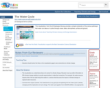
This visualization, from the US Geological Survey, provides a simple schematic of …
This visualization, from the US Geological Survey, provides a simple schematic of the various pathways that water can take as it cycles through ocean, lakes, atmosphere, surface and ground.
DATA: Recent and Historical Earthquake Data. TOOL: ArcExplorer Java Edition for Education …
DATA: Recent and Historical Earthquake Data. TOOL: ArcExplorer Java Edition for Education GIS. SUMMARY: Explore earthquake data and import them into a Geographic Information System (GIS). Analyze the data to predict where the next big earthquake will occur.
(Note: this resource was added to OER Commons as part of a batch upload of over 2,200 records. If you notice an issue with the quality of the metadata, please let us know by using the 'report' button and we will flag it for consideration.)
This is an activity about how much atmospheric pressure is needed on …
This is an activity about how much atmospheric pressure is needed on Mars to maintain surface water and why it does not have surface water today. Learners will use a computer interactive to learn about Mars past and present before exploring the pressure and greenhouse strength needed for Mars to have a watery surface as it had in the past. This lesson is part of Project Spectra, a science and engineering education program focusing on how light is used to explore the Solar System.
This activity is a field investigation where students will make stream observations …
This activity is a field investigation where students will make stream observations to determine its geologic processes and influence to our local topography.
In this exercise, students use U.S. Geological Survey and other websites to …
In this exercise, students use U.S. Geological Survey and other websites to learn about the history of earthquakes in New York. Through their web research, they will learn what earthquakes are, how and where they occur, and the types of hazards associated with large quakes. They are encouraged to write a report summarizing their results.
Optical Mineralogy and thin sections just blew me away when I first …
Optical Mineralogy and thin sections just blew me away when I first was exposed to them. (Of course that was the psychedelic 60's!) Because of my experience, I've always thought that we might attract a major or two if we introduced first-year students to interference colors and such. Therefore, this exercise is primarily intended to be used in an introductory (physical) geology class, perhaps for advanced students or as an extra credit project. It may also be appropriate as a brief introduction ("teaser"?) to optics in a mineralogy or optical class.
(Note: this resource was added to OER Commons as part of a batch upload of over 2,200 records. If you notice an issue with the quality of the metadata, please let us know by using the 'report' button and we will flag it for consideration.)
This lecture/activity allows students to "play with" a toy Slinky in order …
This lecture/activity allows students to "play with" a toy Slinky in order to recognize the implications of an elastic rheology to deformation at shallow crustal levels. Building on already-covered concepts of elasticity and friction, this module adds seismic first motions and earthquake locations to the students conceptual tool bag. As such, this module can be used to segue into other areas of geophyics that are of importance in structural geology (e.g., active tectonics, hazards).
(Note: this resource was added to OER Commons as part of a batch upload of over 2,200 records. If you notice an issue with the quality of the metadata, please let us know by using the 'report' button and we will flag it for consideration.)
Investigations into the oceanŐs role in the global carbon cycle have taken …
Investigations into the oceanŐs role in the global carbon cycle have taken on increasing importance as scientists strive to understand the potential impacts of global change. Join Scripps ocean chemist Lihini Aluwihare as she explains how her research is helping to understand the biology, Geology|Earth Science, and chemistry of the oceans, and ultimately the Planet. (57 minutes)
Science students often have difficulty thinking about large spatial scales. The purpose …
Science students often have difficulty thinking about large spatial scales. The purpose of the exercise is to redo Eratosthenes' calculation of the radius of the Earth using data from to sites in ancient Egypt. The excercise teaches about the methodology of science - how Eratothenes figured it out - rather than worried about what the "right" answer is. It can also be used to discuss the role of models in geological thinking.
(Note: this resource was added to OER Commons as part of a batch upload of over 2,200 records. If you notice an issue with the quality of the metadata, please let us know by using the 'report' button and we will flag it for consideration.)
In this lesson, students learn about major landforms (e.g., mountains, rivers, plains, …
In this lesson, students learn about major landforms (e.g., mountains, rivers, plains, valleys, canyons and plateaus) and how they occur on the Earth's surface. They learn about the civil and geotechnical engineering applications of geology and landforms, including the design of transportation systems, mining, mapping and measuring natural hazards.
This presentation offers an overview of the developing concept of The Anthropocene …
This presentation offers an overview of the developing concept of The Anthropocene -- a term coined to describe our current geological epoch, in which human impact on the planet will leave a permanent trace.
No restrictions on your remixing, redistributing, or making derivative works. Give credit to the author, as required.
Your remixing, redistributing, or making derivatives works comes with some restrictions, including how it is shared.
Your redistributing comes with some restrictions. Do not remix or make derivative works.
Most restrictive license type. Prohibits most uses, sharing, and any changes.
Copyrighted materials, available under Fair Use and the TEACH Act for US-based educators, or other custom arrangements. Go to the resource provider to see their individual restrictions.