The studio will focus on the district of Gaoming, located in the …
The studio will focus on the district of Gaoming, located in the northwest of the Pearl River Delta (PRD) - the fastest growing and most productive region of China. The District has recently completed a planning effort in which several design institutes and a Hong Kong planning firm prepared ideas for a new central area near the river. The class will complement these efforts by focusing on planning and design options on the waterfront of the proposed new district and ways of integrating water/hydrological factors into all aspects and land uses of a modern city (residential, commercial, industrial) - including watershed and natural ecosystem protection, economic and recreational activities, transportation, and tourism.
The lesson plan describes activities focusing on the big question, does eating …
The lesson plan describes activities focusing on the big question, does eating locally grown food help reduce your carbon footprint? Many elements are interconnected and function together to create the natural and productive living system that is your garden. At the end of the activity guide there are additional lesson plans, activity guides, and videos that can help you bring together soil, water, habitat, food, and community to explore your dynamic garden ecosystems.
In this 6th grade science class, students consider how they use water …
In this 6th grade science class, students consider how they use water in their daily lives and learn that water is a nonrenewable resource in a closed system.
In this activity, students study gas laws at a molecular level. They …
In this activity, students study gas laws at a molecular level. They vary the volume of a container at constant temperature to see how pressure changes (Boyle's Law), change the temperature of a container at constant pressure to see how the volume changes with temperature (Charles’s Law), and experiment with heating a gas in a closed container to discover how pressure changes with temperature (Gay Lussac's Law). They also discover the relationship between the number of gas molecules and gas volume (Avogadro's Law). Finally, students use their knowledge of gas laws to model a heated soda can collapsing as it is plunged into ice water.
Students learn how GPS and GIS can be used to gather and …
Students learn how GPS and GIS can be used to gather and analyze point data. The main outcome is a digital map of campus trees classified by size and type. The technical skills learned in this lab will be used in a subsequent lab to analyze water quality data.
(Note: this resource was added to OER Commons as part of a batch upload of over 2,200 records. If you notice an issue with the quality of the metadata, please let us know by using the 'report' button and we will flag it for consideration.)
This course examines diagnostic studies of the Earth’s atmosphere and discusses their …
This course examines diagnostic studies of the Earth’s atmosphere and discusses their implications for the theory of the structure and general circulation of the Earth’s atmosphere. It includes some discussion of the validation and use of general circulation models as atmospheric analogs.
During this activity, the instructor introduces a miniature watershed, named a GeoSandbox, …
During this activity, the instructor introduces a miniature watershed, named a GeoSandbox, to provide a conceptual bridge between the schema created in the soup can water budget activity and the schoolyard watershed activity to follow. Students introduce known quantities of water to the GeoSandbox using spray bottles and measure the resulting surface flow and infiltration. The concepts of topography and land use are also introduced. Additional instructional materials are provided to firmly establish the concept of a watershed for students who need the support.
The Earth’s crust is primarily composed of melting products from mantle plumes …
The Earth’s crust is primarily composed of melting products from mantle plumes and mid-ocean ridges - both presently and over the course of Earth history. While both systems represent upwelling features in a convective mantle, they can be viewed as end-member systems in that plumes represent buoyant flow whereas mid-ocean ridges represent passive corner flow. This paradigm is not strict - flow beneath ridges may be buoyant in some places, for example, but it does provide a reasonable framework for enquiry. Plumes and ridges can be studied independently, but in many places across the globe the systems interact, often in intriguing fashion. The nature of these interactions provides an opportunity to improve our understanding of both systems, and provides new perspectives on the mantle, crustal, and water column processes associated converting heat from the Earth’s interior into new crust, hydrothermal flow, and biological communities on the seafloor. The approach taken for the 2001 Plume-Ridge Interactions Seminar series was to start with basic ideas about mantle convection and tectonics, and an overview of the global hotspot and ridge systems. We then addressed three case studies of plume-ridge interactions in detail. Our first case was the interaction of the. Each of these systems provides a different perspective on the nature of plume-ridge interactions, and by comparison and contrast we are able to distill the fundamental aspects out of the complex array of geophysical and geochemical data associated with plume-ridge systems.
This exercise posits a hypothetical situation: you would like to purchase land …
This exercise posits a hypothetical situation: you would like to purchase land that will provide your family with opportunities to fish and swim in a stream on your property. Additionally, you would like the land to afford some privacy. In order to find such a place, you need to locate land for sale that has a stream running through it and you want to confirm that the stream water is clean. The following activity illustrates how one can locate land with particular characteristics and also assess surface water quality for local bodies of water. The data you will use might pertain to any location where streams flow through residential areas.
(Note: this resource was added to OER Commons as part of a batch upload of over 2,200 records. If you notice an issue with the quality of the metadata, please let us know by using the 'report' button and we will flag it for consideration.)
What factors lead to a natural disaster? What causes a famine? Why …
What factors lead to a natural disaster? What causes a famine? Why do cities flood? According to a recent article in The Atlantic, Houston's flooding during the 2017 Hurricane Harvey was primarily caused by impervious pavement which prevents the absorption of water into the land. This example illustrates how nature and society are interlinked, which is the main focus of Geography 30, Penn State's introductory course to nature-society geography. In addition to examining the linkages between human development and natural hazards, this course will also explore human society's connection to food systems, climate change, urbanization and biodiversity. The course will also cover topics of ethics and decision making in order to help students evaluate the tradeoffs of these interconnections. \The Atlantic\" needs to be made into a link pointing to this: https://www.theatlantic.com/technology/archive/2017/08/why-cities-flood/538251/"
Geography 431 is designed to further understanding of the natural processes of …
Geography 431 is designed to further understanding of the natural processes of aquatic ecosystems, management of water resources, and threats to sustaining water quantity. Develop awareness and appreciation of the perspectives about water as a precious resource, commodity, and sometimes hazard. Learn how and why water is distributed unevenly around the Earth. Examine how resource management decisions are strongly related to water availability, quantity, and quality. The course examines water resources management; dams and dam removal; provision of safe potable water; threats to water quantity and quality; land use changes; the water economy; water laws and policy; institutions for water management at the global, national, regional, and local scale; and issues of water security and climate change.
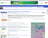
Students analyze topographic and geologic maps, through a set of guiding questions, …
Students analyze topographic and geologic maps, through a set of guiding questions, to figure out why western Kentucky is home to a world-famous cave system. They consider the effect of glaciation on the water table as well as the effects of stratigraphy.
(Note: this resource was added to OER Commons as part of a batch upload of over 2,200 records. If you notice an issue with the quality of the metadata, please let us know by using the 'report' button and we will flag it for consideration.)
Short Description: This is an inquiry based field investigation where students gather …
Short Description: This is an inquiry based field investigation where students gather data on the Credit River from the rocks in the river bed, water speed, and maps. Students interpret their findings and develop new questions.
Students come to this activity having already familiar with the local bedrock …
Students come to this activity having already familiar with the local bedrock geology, and our local stream (it's discharge history and characteristics of the stream, its drainage basin and floodplain, and high-water events. In class, students are introduced to GIS and ArcView, and then use ArcMap to analyze the stream gradient, stream order, and drainage density of Stony Brook. Then students do the same for several major North American rivers. Finally, they move on to Mars, become familiar with some Martian data sets, and use the same tools to compare characteristics of channel-like features on the surface of Mars, to river systems on Earth. The overall task is to synthesize this information and discuss/give evidence for whether or not Earth-like river processes ever operated on Mars.
Are you fascinated by Geosciences and willing to take the challenge of …
Are you fascinated by Geosciences and willing to take the challenge of predicting the nature and behavior of the Earth subsurface? This is your course!
In a voyage through the Earth, Geoscience: the Earth and its Resources will explore the Earth interior and the processes forming mountains and sedimentary basins. You will understand how the sediments are formed, transported, deposited and deformed.
You will develop knowledge on the behavior of petroleum and water resources.
The course has an innovative approach focusing on key fundamental processes, exploring their nature and quantitative interactions. It will be shown how this acquired knowledge is used to predict the nature and behavior of the Earth subsurface.
This is your ideal first step as a future Geoscientists or professional to upgrade your knowledge in the domain of Earth Sciences.
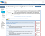
This video describes how geothermal heat resources in California have been tapped …
This video describes how geothermal heat resources in California have been tapped to supply 850 MW of electricity. Images and animations show how the area known as The Geysers has been developed to capture steam, produced from trapped rainwater and heated by the earth. Major challenges include finding suitable geothermal resources to develop, and ensuring that underground water is replenished.
This activity is an easy way to demonstrate the fundamental properties of …
This activity is an easy way to demonstrate the fundamental properties of polar and non-polar molecules (such as water and oil), how they interact, and the affect surfactants (such as soap) have on their interactions. Students see the behavior of oil and water when placed together, and the importance soap (a surfactant) plays in the mixing of oil and water which is why soap is used every day to clean greasy objects, such as hands and dishes. This activity is recommended for all levels of student, grades 3-12, as it can easily be scaled to meet any desired level of difficulty.
Description: In this activity students become acquainted with the anatomy and biology …
Description: In this activity students become acquainted with the anatomy and biology of seeds. They will use lenses and scales and make drawings to scale. Students will measure and calculate magnifications and they will begin to understand relationships among these. They will organize and summarize their data and, as they do so, they will be developing the understanding and skills needed to undertake more detailed investigations on the biology and reproduction of Fast Plants. Learning Objectives This activity is designed to strengthen students' observational and quantitative skills. In participating in this activity students will: - learn to use magnifying lenses, microscopes and dissecting tools for detailed observation" - measure scales with rulers" - draw to scale, with accuracy and precision to understand scale and magnification" - learn features of the external anatomy of seeds that are associated with certain features of the internal anatomy of seeds" and - estimate the amount of water required to be taken up by seeds in order to initiate germination.
This informational text introduces students to solar energy's role in warming the …
This informational text introduces students to solar energy's role in warming the Earth's land and water and to the fact that dark-colored surfaces absorb more of the Sun's energy than do light-colored ones. This version is a full-color PDF that can be printed, cut and folded to form a book. Each book contains color photographs and illustrations. The text is written at a grade two through grade three reading level.
This informational text introduces students to solar energy's role in warming the …
This informational text introduces students to solar energy's role in warming the Earth's land and water and to the fact that dark-colored surfaces absorb more of the Sun's energy than do light-colored ones. This is a PDF containing the informational text and a glossary. The text is written at grade two through grade three reading level.
No restrictions on your remixing, redistributing, or making derivative works. Give credit to the author, as required.
Your remixing, redistributing, or making derivatives works comes with some restrictions, including how it is shared.
Your redistributing comes with some restrictions. Do not remix or make derivative works.
Most restrictive license type. Prohibits most uses, sharing, and any changes.
Copyrighted materials, available under Fair Use and the TEACH Act for US-based educators, or other custom arrangements. Go to the resource provider to see their individual restrictions.