This activity guides students to use the measured difference in P and …
This activity guides students to use the measured difference in P and S wave velocities to locate the epicenter of a minor earthquake in the Southwestern United States.
Click here to view the full activity on the KÃyah Math Project website.
(Note: this resource was added to OER Commons as part of a batch upload of over 2,200 records. If you notice an issue with the quality of the metadata, please let us know by using the 'report' button and we will flag it for consideration.)
KÃyah Math Project development team: Nancy Zumoff, Christopher Schaufele, Steven Semken, Tracy Perkins, Lynn Onken, Philippe Laval, David Gonzales, and Andrew Becenti (deceased).
KÃyah Math Project directed by Steven Semken , Arizona State University; and Christopher Schaufele and Nancy Zumoff, Professors of Mathematics, Emeritus.
Archived at Arizona State University School of Earth and Space Exploration.
Frankenstein200 is a free, episodic online story game paired with a series …
Frankenstein200 is a free, episodic online story game paired with a series of fun hands-on science activities related to robotics, genetic engineering, and electricity. By teaching a robot how to draw, experimenting with simple machines, or even bringing their own “creature” to life, learners will encounter the same questions and ideas Mary Shelley had when writing Frankenstein 200 years ago. In the process, they will develop important skills for exploration, discovery, and critical thinking in the 21st century.
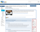
In this visualization, students can explore North American fossil fuel CO2 emissions …
In this visualization, students can explore North American fossil fuel CO2 emissions at very fine resolutions of both space and time. The data is provided by the Vulcan emissions data project, a NASA/DOE funded effort under the North American Carbon Program.
In this activity, students are introduced to impact processes in a study …
In this activity, students are introduced to impact processes in a study of Meteor Crater in northern Arizona. They are guided in the use of a set of relatively simple formulas from physics to estimate the energy of impact and the size of the impactor that formed the crater.
Click here to view the full activity on the KÃyah Math Project website.
(Note: this resource was added to OER Commons as part of a batch upload of over 2,200 records. If you notice an issue with the quality of the metadata, please let us know by using the 'report' button and we will flag it for consideration.)
KÃyah Math Project development team: Nancy Zumoff, Christopher Schaufele, Steven Semken, Tracy Perkins, Lynn Onken, Philippe Laval, David Gonzales, and Andrew Becenti (deceased).
KÃyah Math Project directed by Steven Semken , Arizona State University; and Christopher Schaufele and Nancy Zumoff, Professors of Mathematics, Emeritus.
Archived at Arizona State University School of Earth and Space Exploration.
This is a more mathematically advanced version of the Impact Processes activity …
This is a more mathematically advanced version of the Impact Processes activity that introduces students to impact geology in a study of Meteor Crater in northern Arizona. Students use a set of formulas from physics and power regression on real data to determine the energy released on impact and the size of the impactor that formed the crater.
Click here to view the full activity on the KÃyah Math Project website.
(Note: this resource was added to OER Commons as part of a batch upload of over 2,200 records. If you notice an issue with the quality of the metadata, please let us know by using the 'report' button and we will flag it for consideration.)
KÃyah Math Project development team: Nancy Zumoff, Christopher Schaufele, Steven Semken, Tracy Perkins, Lynn Onken, Philippe Laval, David Gonzales, and Andrew Becenti (deceased).
KÃyah Math Project directed by Steven Semken , Arizona State University; and Christopher Schaufele and Nancy Zumoff, Professors of Mathematics, Emeritus.
Archived at Arizona State University School of Earth and Space Exploration.
The field of feminist studies grew from the U.S. women’s movements of …
The field of feminist studies grew from the U.S. women’s movements of the 1960s and 1970s and has continued to be deeply connected to ongoing movements for social justice. As educational institutions are increasingly seeing public scholarship and community engagement as relevant and fruitful complements to traditional academic work, feminist scholars have much to offer in demonstrating different ways to inform and interact with various communities.
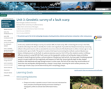
In this unit, students will design a survey (TLS and/or SfM) of …
In this unit, students will design a survey (TLS and/or SfM) of a fault scarp. After conducting the survey in the field, students will analyze the data to identify the number and magnitude of possible fault displacement(s) by measuring offsets in the point cloud as well as calculate the recurrence interval of the fault based on either a known age or scarp morphometric age (or both). The goal is to create a brief report summarizing the methods used and Quaternary history of displacements on the fault. An optional extension exercise (Unit 3.5) has the students conduct a hillslope diffusion analysis is using MATLAB. Fault scarps are the topographic evidence of earthquakes large and shallow enough to break the ground surface, and are evidence of Quaternary fault activity. A primary goal of studying exposed scarps is to gain insight into the magnitude and frequency of fault slip. Scarps typically begin as step-shaped landforms and deteriorate with age through erosion. In some cases, the form of the scarp may record evidence of more than one earthquake, distinguished by a change in scarp slope. Assuming the same surface processes, the relative age of fault scarps can be determined by their morphology (shape).
(Note: this resource was added to OER Commons as part of a batch upload of over 2,200 records. If you notice an issue with the quality of the metadata, please let us know by using the 'report' button and we will flag it for consideration.)
Bruce Douglas (Indiana University)
Nicholas Pinter (University of California Davis)
Nathan Niemi (University of Michigan)
J. Ramon Arrowsmith (Arizona State University)
Kate Shervais (UNAVCO)
Chris Crosby (UNAVCO)
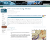
Applications of geodetic imaging in geomorphology research often center on monitoring and …
Applications of geodetic imaging in geomorphology research often center on monitoring and detecting change within a system over time. Since most geomorphic systems evolve over longer time periods -- months, years, or more -- than available in a typical field course, this unit of the module may be entirely lab-based. Or you may have students collect data -- of a fluvial system, landslide, or other geomorphic feature -- if the feature they survey has a previously collected data set upon which to compare their new data set. The goal of this unit is to teach students to transform point clouds of a feature taken some time apart into DEMs. The DEMs are then subtracted to calculate the elevation change over time.
(Note: this resource was added to OER Commons as part of a batch upload of over 2,200 records. If you notice an issue with the quality of the metadata, please let us know by using the 'report' button and we will flag it for consideration.)
Kate Shervais (UNAVCO)
J. Ramon Arrowsmith (Arizona State University)
Nathan Niemi (University of Michigan)
Marin Clark (University of Michigan)
Chris Crosby (UNAVCO)
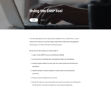
The Data Management and Sharing Plan (DMSP) Tool, or DMPTool, is a …
The Data Management and Sharing Plan (DMSP) Tool, or DMPTool, is a free resource for anyone to use that helps researchers create data management sharing plans as they write their funding proposal.
By the end of this tutorial, you will be able to: - Log in to the DMPTool as an institutional affiliate. - Access and use existing data management plans and templates. - Identify project details for your plan that meet funder and institutional guidelines. - Identify research outputs needed to meet funder and institutional guidelines. - Request expert feedback for your plan.
Recall the steps to save, download, and submit your plan to your Research Administrator and submit updates as your project progresses.
Students are provided with equations and geological data to estimate the velocities …
Students are provided with equations and geological data to estimate the velocities and impact effects of volcanic bombs that were ejected during the last eruption of Sunset Crater, a young cinder cone volcano in northern Arizona.
Click here to view the full activity on the KÃyah Math Project website.
(Note: this resource was added to OER Commons as part of a batch upload of over 2,200 records. If you notice an issue with the quality of the metadata, please let us know by using the 'report' button and we will flag it for consideration.)
KÃyah Math Project development team: Nancy Zumoff, Christopher Schaufele, Steven Semken, Tracy Perkins, Lynn Onken, Philippe Laval, David Gonzales, and Andrew Becenti (deceased).
KÃyah Math Project directed by Steven Semken , Arizona State University; and Christopher Schaufele and Nancy Zumoff, Professors of Mathematics, Emeritus.
Archived at Arizona State University School of Earth and Space Exploration.
No restrictions on your remixing, redistributing, or making derivative works. Give credit to the author, as required.
Your remixing, redistributing, or making derivatives works comes with some restrictions, including how it is shared.
Your redistributing comes with some restrictions. Do not remix or make derivative works.
Most restrictive license type. Prohibits most uses, sharing, and any changes.
Copyrighted materials, available under Fair Use and the TEACH Act for US-based educators, or other custom arrangements. Go to the resource provider to see their individual restrictions.