Students are introduced to a simple approach to scientific writing. To make …
Students are introduced to a simple approach to scientific writing. To make the writing process immediately relevant to them, I present the approach after they have started the first assignment of the semester (whether lab or homework) but before it is due. Thus, students are more attentive to the presentation and are more invested in trying to apply the approach to a current assignment. As a class, we begin by answering the question "what did you do?" followed by answering the questions "who, what, where, when, how, and why?" as appropriate to develop the first paragraph/section. Next, we answer the question "what did you find?" followed by the questions "who, what, where, when, how, and why?" as appropriate to develop the second paragraph/section. Finally, we review what we have written and add the finishing touches (e.g., title, references, figures, etc.). Thus, students learn how to pose and answer basic questions that form the basis of a scientific report.
(Note: this resource was added to OER Commons as part of a batch upload of over 2,200 records. If you notice an issue with the quality of the metadata, please let us know by using the 'report' button and we will flag it for consideration.)
These are skeleton notes to accompany lectures in Physical Science I.Topics covered:Solar …
These are skeleton notes to accompany lectures in Physical Science I.Topics covered:Solar SystemRocks and MineralsBuilding Earth's Surface: Folds and FaultsTsunamisThe AtmosphereThe HydrosphereWeatherClimate
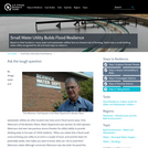
Based on their locations, many water and wastewater utilities face an inherent …
Based on their locations, many water and wastewater utilities face an inherent risk of flooding. Here’s how a small drinking water utility recognized its risk and took steps to reduce it.
Engineers work in many fields associated with precipitation. Engineers study glaciers to …
Engineers work in many fields associated with precipitation. Engineers study glaciers to better understand their dates of formation and current demise. They deal with issues of pollution transport and water yield, and they monitor reservoirs and dams to prevent flooding.
In this video segment adapted from ZOOM, cast members assemble a solar …
In this video segment adapted from ZOOM, cast members assemble a solar still and make fresh water from saltwater, demonstrating two steps of the water cycle, evaporation and condensation.
The mission of Southwest Research and Information Center is to promote the …
The mission of Southwest Research and Information Center is to promote the health of people and communities, protect natural resources, ensure citizen participation, and secure environmental and social justice now and for future generations. The Uranium Impact Assessment Program contains information about current issues dealing with the Navajo Nation. Useful fact sheets are found on this site.
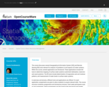
The course discusses several Geopgraphical Information System (GIS) and Remote Sensing (RS) …
The course discusses several Geopgraphical Information System (GIS) and Remote Sensing (RS) tools relevant for analysis of (problems in and aspects of) water systems. Within the course, several applications are introduced. These applications include GIS tools to determine mapping of surface water systems (catchment delineation, reservoirs and canal systems). The RS tools include determination of evaporation and soil moisture patterns, and measurement of water levels in surface water systems. In exercises and lectures, different tools and applications are offered. For each application, assignments are given to allow students to acquire relevant skills. The course structure combines assignments and introductory lectures. Each week participants work on one assignment. These assignments are discussed in the next lecture and graded. Each week a new assignment is introduced, together with supporting materials (an article discussing the relevant application) and lectures (introducing theoretical issues). The study material of the course consists of a study guide, assignments, lecture material and articles. The final mark is the average of the grades of the individual assignments.
This is an assignment I worked on with Dr. Brusseau (University of …
This is an assignment I worked on with Dr. Brusseau (University of Arizona) for his Contaminant Transport class. In this problem solving exercise, students are provided data sets that could be obtained by monitoring flow and transport of a tracer or contaminant in the field or in a soil column experiment in the laboratory. They will need to input the equations into a spreadsheet to complete the assignment.
(Note: this resource was added to OER Commons as part of a batch upload of over 2,200 records. If you notice an issue with the quality of the metadata, please let us know by using the 'report' button and we will flag it for consideration.)
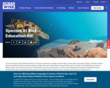
In our new Species at Risk (SAR) education kit, each lesson addresses …
In our new Species at Risk (SAR) education kit, each lesson addresses a species at risk through an Ocean Wise conservation initiative. Students will learn about the humpback whale and climate change, the killer whale and ocean pollution, the great white shark and bycatch, the hawksbills sea turtle and plastic pollution, and the sea otter and loss of kelp habitat, plus ways to take action to protect them! Equipped with the proper knowledge and tools, students will acquire an impactful learning experience to empower them to become ocean champions and stewards for species at risk.
The Earth’s ocean and its interconnected systems depend on marine species to maintain the efficiency and balance of the functioning of their ecosystems. Their role in the ocean has a direct impact on its health and our own. And yet, every day, thousands of animals fall victim to anthropogenic threats imposed on the ocean by human activity. It is going to take a deep, transformational change in humanity’s consciousness and behaviours regarding our oceans to ensure the protection of species. We believe this is possible by providing climate and conservation education to our youth to raise awareness on the interconnectedness between our lives and the ocean, and the importance of the role that each species holds on our planet.
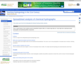
Students download a comma-delimited data set that is a time series of …
Students download a comma-delimited data set that is a time series of stream discharge measurements and the concentration of a trace element in the stream. Given the concentration of this element in the precipitation and in the groundwater, the students analyze the data using spreadsheet software to separate the hydrograph into baseflow and quickflow components. Students produce a graph of their results. To do the analysis, students must derive an appropriate equation based on other equations presented in the text (Eqs. 1.2 and 1.3).
(Note: this resource was added to OER Commons as part of a batch upload of over 2,200 records. If you notice an issue with the quality of the metadata, please let us know by using the 'report' button and we will flag it for consideration.)
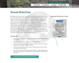
Who doesn’t love to toss sticks or leaves into a stream and …
Who doesn’t love to toss sticks or leaves into a stream and watch them move in the current? Who doesn’t love mysteries? In Stream Detectives, students get to explore a stream, figuring out how the currents move by using stick and leaf “boats” to track the speed and direction of different currents. Students learn about some of the factors that affect current speed and direction (hydrodynamics), how water shapes stone (weathering), how the channel of a stream changes over time (stream morphology), and how the speed of the current affects the size of sediment that it leaves behind (erosion). Then, they apply this knowledge by using a Stream Detective Key to figure out how the stream features they see in the moment formed in the past, and to predict how they might change in the future. Students learn skills and concepts they can use to interpret and learn about any stream they encounter.
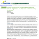
This activity is a field investigation where students will make stream observations …
This activity is a field investigation where students will make stream observations to determine its geologic processes and influence to our local topography.
In this activity, students use elevation and distance data to construct graphic …
In this activity, students use elevation and distance data to construct graphic profiles and determine the average gradients for three streams. A series of discussion questions addresses concepts of deposition, erosion, and nickpoints, and gives students practice compiling evidence to provide scientific explanations. Graphs can be constructed by hand on paper or generated using graphing software.
Watershed Awareness using Technology and Environmental Research for Sustainability (WATERS) The WATERS …
Watershed Awareness using Technology and Environmental Research for Sustainability (WATERS)
The WATERS project is developing and researching a student-centered, place-based, and accessible curriculum for teaching watershed concepts and water career awareness for students in the middle grades. This 10-lesson unit includes online, classroom, and field activities. Students use a professional-grade online GIS modeling resource, simulations, sensors, and other interactive resources to collect environmental data and analyze their local watershed issues. The WATERS project is paving a path to increased access to research-based, open access curricula that hold the potential to significantly increase awareness of and engagement with watershed concepts and career pathways in learners nationwide.
This material is licensed under a Creative Commons Attribution 4.0 License. The software is licensed under Simplified BSD, MIT or Apache 2.0 licenses. Please provide attribution to the Concord Consortium and the URL https://concord.org.
The students will conduct a fluvial sediment transport study in Little Fountain …
The students will conduct a fluvial sediment transport study in Little Fountain Creek basin. The overall goal is to compare the size of clasts in the streambed material to the size of clasts that can be transported by various flood events. The objectives are to: 1. characterize the size, shape, and composition of the streambed sediment and interpret changes in the downstream direction 2. assess the size of the sediment that might be transported for a flood with a 2-yr, a 10-yr, and a 100-yr recurrence interval 3. estimate the recurrence interval of the 2013 flood and the size of sediment that event might have transported 4. integrate knowledge gained in a written report with appropriate visual elements.
(Note: this resource was added to OER Commons as part of a batch upload of over 2,200 records. If you notice an issue with the quality of the metadata, please let us know by using the 'report' button and we will flag it for consideration.)
This activity is a field investigation using science inquiry and problem solving, …
This activity is a field investigation using science inquiry and problem solving, where small groups of students design their own experiment to determine stream velocity, collect and analyze their data, draw conclusions, and make further inferences based group discussion/collaboration.
O jogo fora construído com base em dados disponíveis em base de …
O jogo fora construído com base em dados disponíveis em base de dados diversos como o site da Agência Nacional de Águas, Agências de Meio Ambiente dos Estados, artigos científicos publicados em eventos, relatórios de gestão de comitê de bacias hidrográficas ou outras fontes que servissem como fieis disseminadores da informação que estava sendo buscada. No geral, essa foi a parte mais dificultosa do trabalho a coleta dos dados dos rios pela disseminação da informação em várias fontes, pela pouca padronização de informação. Destarte, priorizamos dados gerais e que pudessem ser comparados como extensão do rio e área da bacia hidrográfica, por exemplo. A justificativa está na possibilidade de aplicação de conteúdos, conceitos e elementos de diferentes áreas do conhecimento como Geografia, Matemática e Biologia, permitindo a integração de diferentes ações entre professores de várias áreas de conhecimento, em meio às variações de possibilidade de interação pedagógica, mediada, portanto, pela aplicação de jogos didáticos em sala de aula. Tendo em vista a proposta de trabalhar com alunos com deficiência o jogo fora pensado para responder às demandas de alunos com múltiplas deficiências usando princípios do Universal Design for Learning (UDL) ou Desenho Universal para Aprendizagem (DUA). O DUA se baseia então em três princípios genéricos: (i) proporcionar múltiplos meios de envolvimento, de forma que seja possível estimular o interesse dos alunos e motivá-los para a aprendizagem recorrendo a múltiplas formas; (ii) proporcionar múltiplos meios de representação de forma que seja possível apresentar a informação e o conteúdo em múltiplos formatos para que todos tenham acesso e; (iii) Proporcionar múltiplos meios de ação e expressão nas quais seja possível permitir formas alternativas de expressão e de demonstração das aprendizagens, por parte dos alunos (NUNES e MADUREIRA, 2015). Essas ferramentas permitem possibilidades mais flexíveis em que seja possível “pensar na acessibilidade desde a concepção dos projetos [educacionais] […] [enquanto] uma solução mais atrativa e necessária à sociedade contemporânea” (RICARDO, SAÇO e FERREIRA, 2017, p. 1527). As barreiras que existirem para o processo educacional, serão reduzidas pela flexibilidade do currículo, por suporte aos docentes na melhoria do acesso ao conhecimento e à aprendizagem dentro da sala de aula. Para esse produto técnico foi pensado em um Sistemas de Comunicação Alternativa e Ampliada (SCAA) que pode ser entendido como um recurso que codifica e transmite mensagens sem que seja necessário recrutar habilidades de escrita ou vocalização (GOMIDE, 2017). Os SCAA possuem uma variação expressiva que vai desde “o uso de gestos, língua de sinais, expressões faciais, o uso de pranchas de alfabeto, de símbolos pictográficos, ou ainda pelo uso de sistemas sofisticados de computador com voz sintetizada, por exemplo” (GOMIDE, 2017, p. 25). Vários são os SCAA disponíveis no mercado, podendo os profissionais de optar por recursos de baixa tecnologia ou recursos de alta tecnologia (GOMIDE, 2017). Os Recursos de Baixa Tecnologia referem-se a recursos mais acessíveis que possibilitam a comunicação quando inexiste a linguagem oral e podem ser usados em Pranchas de Comunicações Alternativa (PCA). Por ser um sistema de linguagem imagético e pictórico a PCA pode ser editada para contemplar a necessidade que se apresentar para cada aluno especificamente. Gomide (2017) aponta que é necessário ter em vista o nível cultural e escolar das pessoas que irão utilizar aquele sistema para que a linguagem usada possa ser acessível. A linguagem textual é útil para usuários alfabetizados e a linguagem imagética pode ser aplicada para qualquer usuário.
Students are introduced to superhydrophobic surfaces and the "lotus effect." Water spilled …
Students are introduced to superhydrophobic surfaces and the "lotus effect." Water spilled on a superhydrophobic surface does not wet the surface, but simply rolls off. Additionally, as water moves across the superhydrophobic surface, it picks up and carries away any foreign material, such as dust or dirt. Students learn how plants create and use superhydrophobic surfaces in nature and how engineers have created human-made products that mimic the properties of these natural surfaces. They also learn about the tendency of all superhydrophobic surfaces to develop water droplets that do not roll off the surface but become "pinned" under certain conditions, such as water droplets formed from condensation. They see how the introduction of mechanical energy can "unpin" these water droplets and restore the desirable properties of the superhydrophobic surface.
Students are provided the latitude and longitude of various locations and asked …
Students are provided the latitude and longitude of various locations and asked to identify the river stage or surface water deposition/erosional feature.
No restrictions on your remixing, redistributing, or making derivative works. Give credit to the author, as required.
Your remixing, redistributing, or making derivatives works comes with some restrictions, including how it is shared.
Your redistributing comes with some restrictions. Do not remix or make derivative works.
Most restrictive license type. Prohibits most uses, sharing, and any changes.
Copyrighted materials, available under Fair Use and the TEACH Act for US-based educators, or other custom arrangements. Go to the resource provider to see their individual restrictions.