In Part 1 of this unit, students will develop protocols for the …
In Part 1 of this unit, students will develop protocols for the collection of sensory data to address a guiding question. The data collected will consist of scents or sounds. The advantage of using sensory data is that students are equipped with the analytical equipment (ears and nose) and are familiar with its use. However, students may not have taken the time to consider the variety of perceptions that occur within a group of people who are sharing a sensory experience and the impact that variation can have when attempting to collect objective data to help characterize environmental problems. Protocols are necessary to ensure consistency of data between collection points and between data collectors, and to link data collected to a research question. Protocols also serve as a record of the methodology used by an investigator that may be subject to scrutiny by subsequent data users or by anyone reading or using a report containing the data. Data collection in all scientific fields may be collected using protocols common within the field or developed by an investigator for use in a specific study. Because sensory data is inherently qualitative and subjective, students will need to develop methods of quantification that ensure as much objectivity as possible. Likewise, scientists collecting field data may need to develop unique protocols that ensure that field data is collected in as objective a manner as possible. Ideally, the unit will span two class sessions to allow for the gradual development of a data collection protocol and field plan.
(Note: this resource was added to OER Commons as part of a batch upload of over 2,200 records. If you notice an issue with the quality of the metadata, please let us know by using the 'report' button and we will flag it for consideration.)
In Part 2 of this unit, student groups will plan and execute …
In Part 2 of this unit, student groups will plan and execute the field collection of sensory data (scents and/or sounds) using previously developed data collection protocols. The advantage of using sensory data is that students are equipped with the analytical equipment (ears and nose) and are familiar with its use. Class time will be devoted to developing a field investigation plan. Students will create guiding questions and choose a study area, develop or obtain maps of the study area, assign field roles to group members, and develop a timeline for completion of fieldwork. The plan will need to ensure proper execution of data collection protocol, a clear record of the data collected, and a record of field conditions. Careful planning of fieldwork is important to ensure that the time in the field is utilized efficiently and effectively and that the data collected meets the intended requirements. Likewise, an environmental professional (such as a geoscientist) undertaking an environmental investigation would need to develop a field investigation plan to meet the needs of the investigation.
(Note: this resource was added to OER Commons as part of a batch upload of over 2,200 records. If you notice an issue with the quality of the metadata, please let us know by using the 'report' button and we will flag it for consideration.)
This write-pair-share activity presents Calculus III students with a worksheet containing several …
This write-pair-share activity presents Calculus III students with a worksheet containing several exercises that require them to find partial derivatives of functions of two variables. Afterwards, a series of Web-based animations are used to illustrate the surface of each function, the path of the indicated partial derivative for a specified value of the variable and the value of the derivative at each point along the path.
This activity uses cooperative learning to identify minerals in hand sample based …
This activity uses cooperative learning to identify minerals in hand sample based on physical properties. The "Jigsaw" pedagogy upon which this lab is based provides the environment for four succeeding labs in which the students learn the megascopic characteristic properties, chemical composition, and a geologic significance for each of approximately 100 minerals.
(Note: this resource was added to OER Commons as part of a batch upload of over 2,200 records. If you notice an issue with the quality of the metadata, please let us know by using the 'report' button and we will flag it for consideration.)
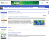
This activity is a slight variation on an original activity, Discovering Plate …
This activity is a slight variation on an original activity, Discovering Plate Boundaries, developed by Dale Sawyer at Rice University. I made different maps, including more detail in all of the datasets, and used a different map projection, but otherwise the general progression of the activity is the same. More information about jigsaw activities in general can be found in the Jigsaws module.
The activity occurs in several sections, which can be completed in one or multiple classes. In the first section, students are divided into "specialist" groups, and each group is given a global map with a single dataset: global seismicity, volcanoes, topography, age of the seafloor, and free-air gravity. Each student is also given a map of plate boundaries. Their task in the specialist group is to become familiar with their dataset and develop categories of plate boundaries based only on their dataset. Each group then presents their results to the class.
In the second section, students reorganize into groups with 1-2 of each type of specialist per group. Each new group is given a plate, and they combine their different datasets on that one plate and look for patterns. Again, each plate group presents to the class. The common patterns and connections between the different datasets quickly become apparent, and the final section of the activity involves a short lecture from the instructor about types of plate boundaries and why the common features are generated at those plate boundaries. A follow-up section or class involves using a problem-solving approach to explain the areas that don't "fit" into the typical boundary types - intra-plate volcanism, earthquakes in the Eastern California Shear Zone, etc.
(Note: this resource was added to OER Commons as part of a batch upload of over 2,200 records. If you notice an issue with the quality of the metadata, please let us know by using the 'report' button and we will flag it for consideration.)
Cooperation and critical thinking are the name of the game as students …
Cooperation and critical thinking are the name of the game as students use baseball facts they find online to create trivia questions for a class Jeopardy game.
Play is something that every child enjoys doing. Since this is the …
Play is something that every child enjoys doing. Since this is the case why not use play as a tool for education? Playing with the intent to learn is a great way to keep students interested and motivated in the lessons. This OER talks about different aspects of using play as a learning tool and why it is beneficial for all students.
To prepare for this exercise, students will read about the Earth's energy …
To prepare for this exercise, students will read about the Earth's energy balance, the electromagnetic spectrum (including visible solar and invisible infrared energy), the effect of the earth's atmosphere, and the earth's resulting general oceanic and atmospheric circulation. For this I like Chapters 3, 4, & 5 in "The Earth System" (2nd Ed.) by Kump, Kasting, & Crane. The students' first step is to estimate zonal averages of Incoming Solar (Shortwave), Absorbed Shortwave, and Outgoing Longwave Radiation from 11x17in color maps of Earth Radiation Budget Experiment (ERBE) data. Then I remix the groups and they create zonal averages of these data at particular longitudes (like Fig. 2-14 in Ruddiman, "Earth's Climate: Past & Future").
(Note: this resource was added to OER Commons as part of a batch upload of over 2,200 records. If you notice an issue with the quality of the metadata, please let us know by using the 'report' button and we will flag it for consideration.)
Where did the stars come from? What makes lightning and thunder? Pourquoi …
Where did the stars come from? What makes lightning and thunder? Pourquoi tales are narratives developed by various cultures around the world to explain natural phenomena. Students study three tales and learn about their cultures of origin, then work cooperatively to write and present an original pourquoi tale.
This activity is an opportunity for students to explore civil government and …
This activity is an opportunity for students to explore civil government and to present what they have learned about electric power generation in a persuasive manner
Students work as a team to determine the causes, effects, and solutions …
Students work as a team to determine the causes, effects, and solutions to ozone depletion. They work out what they need to know, and split the team up to research different parts of the issue.
(Note: this resource was added to OER Commons as part of a batch upload of over 2,200 records. If you notice an issue with the quality of the metadata, please let us know by using the 'report' button and we will flag it for consideration.)
Students use a hundred board to eliminate numbers after reading each clue. …
Students use a hundred board to eliminate numbers after reading each clue. Students must apply their knowledge of even-odd, multiples and place value to successfully eliminate numbers until the solution is revealed.
Students create a checklist outlining what effective writers do, revise his or …
Students create a checklist outlining what effective writers do, revise his or her own writing, and engage in a written conversation to help peers with the revision process.
Groups of 3-4 students work in parallel on different radiocarbon data sets …
Groups of 3-4 students work in parallel on different radiocarbon data sets in this project assignment; the content described here would comprise one group data set including a brief descriptive statement and bibliographic reference, raw data including errors, background lecture notes, and an example final poster presentation.
(Note: this resource was added to OER Commons as part of a batch upload of over 2,200 records. If you notice an issue with the quality of the metadata, please let us know by using the 'report' button and we will flag it for consideration.)
This activity is a guided inquiry investigation where students gather data on …
This activity is a guided inquiry investigation where students gather data on rate of water falling on erosion. Student will interpret their data, and develop a conclusion from the data. The data will lead to further questions, which can be developed by the students.
This is a short experimental study of what happens to aluminum hydroxide, …
This is a short experimental study of what happens to aluminum hydroxide, silicic acid, magnesium oxide, and calcium carbonate (or reagents of instructors choice) when they are heated to 110 and 1200 degrees.
Students determine the formula and calculate the mole percent and weight percent of each element and oxide in each reagent. They heat the samples and calculate percentage weight loss or gain. Finally, they write a lab report summarizing their results.
Be sure to have students save their samples for later use in a lab that introduces X-ray diffraction.
(Note: this resource was added to OER Commons as part of a batch upload of over 2,200 records. If you notice an issue with the quality of the metadata, please let us know by using the 'report' button and we will flag it for consideration.)
A case for the analysis of externalities (social costs and benefits) in …
A case for the analysis of externalities (social costs and benefits) in the context of recycling. Drawn from a program in New York City.
(Note: this resource was added to OER Commons as part of a batch upload of over 2,200 records. If you notice an issue with the quality of the metadata, please let us know by using the 'report' button and we will flag it for consideration.)
No restrictions on your remixing, redistributing, or making derivative works. Give credit to the author, as required.
Your remixing, redistributing, or making derivatives works comes with some restrictions, including how it is shared.
Your redistributing comes with some restrictions. Do not remix or make derivative works.
Most restrictive license type. Prohibits most uses, sharing, and any changes.
Copyrighted materials, available under Fair Use and the TEACH Act for US-based educators, or other custom arrangements. Go to the resource provider to see their individual restrictions.